{"title":"Development of a method for walking step observation based on large-scale GPS data.","authors":"Shohei Nagata, Tomoki Nakaya, Tomoya Hanibuchi, Naoki Nakaya, Atsushi Hozawa","doi":"10.1186/s12942-022-00312-5","DOIUrl":null,"url":null,"abstract":"<p><strong>Background: </strong>Widespread use of smartphones has enabled the continuous monitoring of people's movements and physical activity. Linking global positioning systems (GPS) data obtained via smartphone applications to physical activity data may allow for large-scale and retrospective evaluation of where and how much physical activity has increased or decreased due to environmental, social, or individual changes caused by policy interventions, disasters, and infectious disease outbreaks. However, little attention has been paid to the use of large-scale commercial GPS data for physical activity research due to limitations in data specifications, including limited personal attribute and physical activity information. Using GPS logs with step counts measured by a smartphone application, we developed a simple method for daily walking step estimation based on large-scale GPS data.</p><p><strong>Methods: </strong>The samples of this study were users whose GPS logs were obtained in Sendai City, Miyagi Prefecture, Japan, during October 2019 (37,460 users, 36,059,000 logs), and some logs included information on daily step counts (731 users, 450,307 logs). The relationship between land use exposure and daily step counts in the activity space was modeled using the small-scale GPS logs with daily step counts. Furthermore, we visualized the geographic distribution of estimated step counts using a large set of GPS logs with no step count information.</p><p><strong>Results: </strong>The estimated model showed positive relationships between visiting high-rise buildings, parks and public spaces, and railway areas and step counts, and negative relationships between low-rise buildings and factory areas and daily step counts. The estimated daily step counts tended to be higher in urban areas than in suburban areas. Decreased step counts were mitigated in areas close to train stations. In addition, a clear temporal drop in step counts was observed in the suburbs during heavy rainfall.</p><p><strong>Conclusions: </strong>The relationship between land use exposure and step counts observed in this study was consistent with previous findings, suggesting that the assessment of walking steps based on large-scale GPS logs is feasible. The methodology of this study can contribute to future policy interventions and public health measures by enabling the retrospective and large-scale observation of physical activity by walking.</p>","PeriodicalId":48739,"journal":{"name":"International Journal of Health Geographics","volume":" ","pages":"10"},"PeriodicalIF":3.0000,"publicationDate":"2022-09-07","publicationTypes":"Journal Article","fieldsOfStudy":null,"isOpenAccess":false,"openAccessPdf":"https://www.ncbi.nlm.nih.gov/pmc/articles/PMC9449285/pdf/","citationCount":"0","resultStr":null,"platform":"Semanticscholar","paperid":null,"PeriodicalName":"International Journal of Health Geographics","FirstCategoryId":"3","ListUrlMain":"https://doi.org/10.1186/s12942-022-00312-5","RegionNum":2,"RegionCategory":"医学","ArticlePicture":[],"TitleCN":null,"AbstractTextCN":null,"PMCID":null,"EPubDate":"","PubModel":"","JCR":"Q2","JCRName":"PUBLIC, ENVIRONMENTAL & OCCUPATIONAL HEALTH","Score":null,"Total":0}
引用次数: 0
Abstract
Background: Widespread use of smartphones has enabled the continuous monitoring of people's movements and physical activity. Linking global positioning systems (GPS) data obtained via smartphone applications to physical activity data may allow for large-scale and retrospective evaluation of where and how much physical activity has increased or decreased due to environmental, social, or individual changes caused by policy interventions, disasters, and infectious disease outbreaks. However, little attention has been paid to the use of large-scale commercial GPS data for physical activity research due to limitations in data specifications, including limited personal attribute and physical activity information. Using GPS logs with step counts measured by a smartphone application, we developed a simple method for daily walking step estimation based on large-scale GPS data.
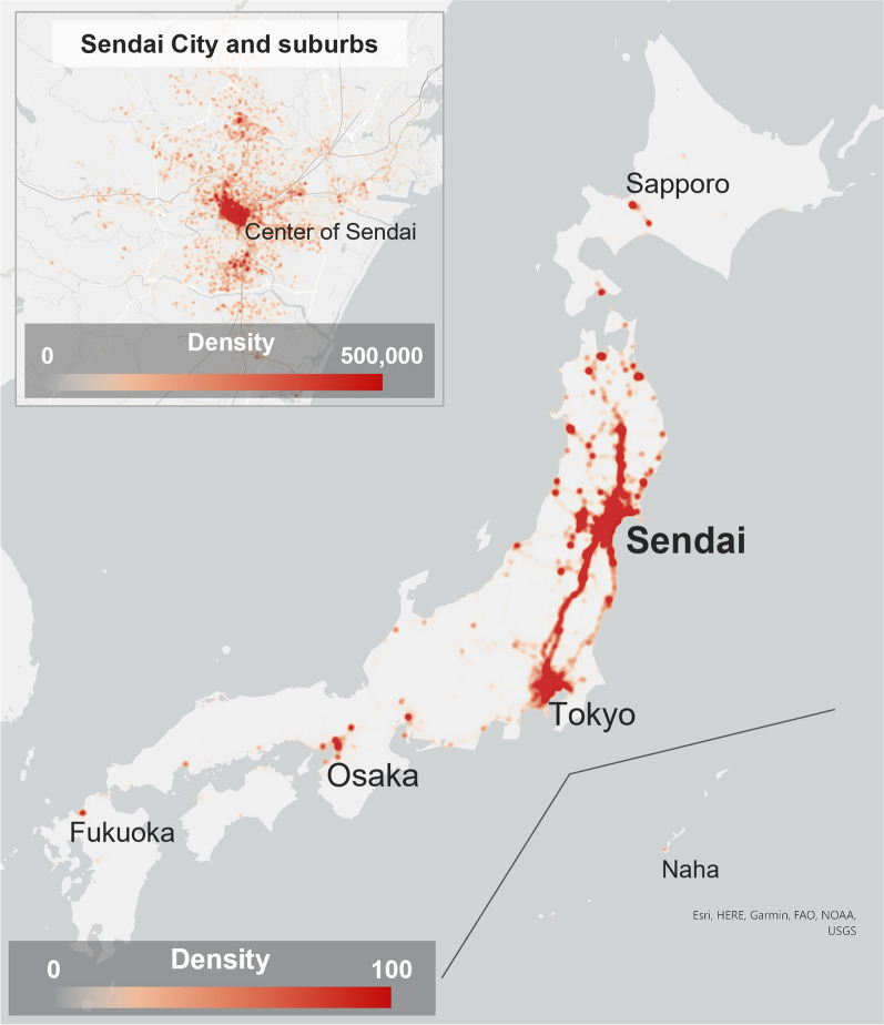
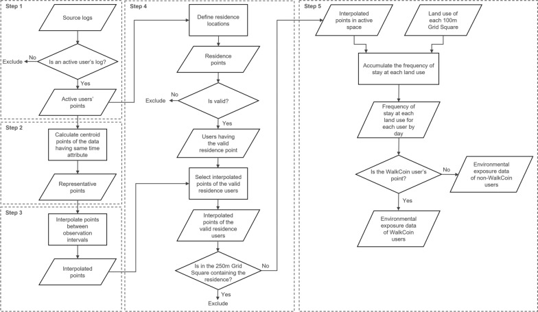
Methods: The samples of this study were users whose GPS logs were obtained in Sendai City, Miyagi Prefecture, Japan, during October 2019 (37,460 users, 36,059,000 logs), and some logs included information on daily step counts (731 users, 450,307 logs). The relationship between land use exposure and daily step counts in the activity space was modeled using the small-scale GPS logs with daily step counts. Furthermore, we visualized the geographic distribution of estimated step counts using a large set of GPS logs with no step count information.
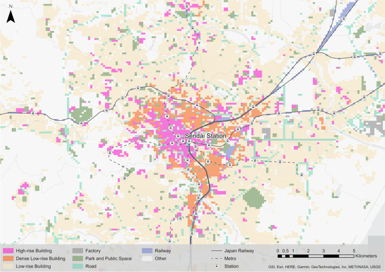
Results: The estimated model showed positive relationships between visiting high-rise buildings, parks and public spaces, and railway areas and step counts, and negative relationships between low-rise buildings and factory areas and daily step counts. The estimated daily step counts tended to be higher in urban areas than in suburban areas. Decreased step counts were mitigated in areas close to train stations. In addition, a clear temporal drop in step counts was observed in the suburbs during heavy rainfall.
Conclusions: The relationship between land use exposure and step counts observed in this study was consistent with previous findings, suggesting that the assessment of walking steps based on large-scale GPS logs is feasible. The methodology of this study can contribute to future policy interventions and public health measures by enabling the retrospective and large-scale observation of physical activity by walking.
期刊介绍:
A leader among the field, International Journal of Health Geographics is an interdisciplinary, open access journal publishing internationally significant studies of geospatial information systems and science applications in health and healthcare. With an exceptional author satisfaction rate and a quick time to first decision, the journal caters to readers across an array of healthcare disciplines globally.
International Journal of Health Geographics welcomes novel studies in the health and healthcare context spanning from spatial data infrastructure and Web geospatial interoperability research, to research into real-time Geographic Information Systems (GIS)-enabled surveillance services, remote sensing applications, spatial epidemiology, spatio-temporal statistics, internet GIS and cyberspace mapping, participatory GIS and citizen sensing, geospatial big data, healthy smart cities and regions, and geospatial Internet of Things and blockchain.
 求助内容:
求助内容: 应助结果提醒方式:


