{"title":"Identification and Analysis of Multiscale Displacement Fields by SAR Interferometry Methods: Case Study of the Crimean Peninsula","authors":"R. S. Osmanov, M. S. Volkova, V. O. Mikhailov","doi":"10.1134/S1069351326700382","DOIUrl":null,"url":null,"abstract":"<p>This paper presents the results of displacement monitoring over a vast area of the Crimean Peninsula for the period from 2020 to 2024, based on images from satellites equipped with a synthetic aperture radar (SAR). The displacement fields were analyzed and interpreted at both regional and local scales. It was found that 99% (3σ) of the average surface displacement velocities range from –23 to 23 mm/yr. A block structure consistent with the locations of several active tectonic faults is observed in the regional component of the field of average displacement velocities. The dynamics of the regional negative and positive displacements derived from InSAR data are consistent with the subsidence of the Sivash Basin and the uplift of the Kerch Upland, a trend known from tectonic schemes. The causes of local natural or anthropogenic processes revealed in individual areas are discussed. At the local scale, the algorithm for detecting anomalous deformation zones proposed in the paper identified 61 sites with sizes ranging from 0.1 to 2.3 km<sup>2</sup>. Among these, areas affected by landslide processes are of particular importance. The dynamics of individual landslide masses is studied. The results demonstrate the high effectiveness of radar interferometry for solving a wide range of fundamental and practical problems, including those related to environmental issues and public safety.</p>","PeriodicalId":602,"journal":{"name":"Izvestiya, Physics of the Solid Earth","volume":"62 3","pages":"469 - 480"},"PeriodicalIF":0.7000,"publicationDate":"2026-07-17","publicationTypes":"Journal Article","fieldsOfStudy":null,"isOpenAccess":false,"openAccessPdf":"","citationCount":"0","resultStr":null,"platform":"Semanticscholar","paperid":null,"PeriodicalName":"Izvestiya, Physics of the Solid Earth","FirstCategoryId":"89","ListUrlMain":"https://link.springer.com/article/10.1134/S1069351326700382","RegionNum":4,"RegionCategory":"地球科学","ArticlePicture":[],"TitleCN":null,"AbstractTextCN":null,"PMCID":null,"EPubDate":"","PubModel":"","JCR":"Q4","JCRName":"GEOCHEMISTRY & GEOPHYSICS","Score":null,"Total":0}
引用次数: 0
Abstract
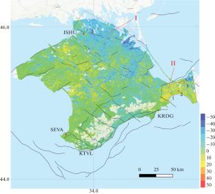
This paper presents the results of displacement monitoring over a vast area of the Crimean Peninsula for the period from 2020 to 2024, based on images from satellites equipped with a synthetic aperture radar (SAR). The displacement fields were analyzed and interpreted at both regional and local scales. It was found that 99% (3σ) of the average surface displacement velocities range from –23 to 23 mm/yr. A block structure consistent with the locations of several active tectonic faults is observed in the regional component of the field of average displacement velocities. The dynamics of the regional negative and positive displacements derived from InSAR data are consistent with the subsidence of the Sivash Basin and the uplift of the Kerch Upland, a trend known from tectonic schemes. The causes of local natural or anthropogenic processes revealed in individual areas are discussed. At the local scale, the algorithm for detecting anomalous deformation zones proposed in the paper identified 61 sites with sizes ranging from 0.1 to 2.3 km2. Among these, areas affected by landslide processes are of particular importance. The dynamics of individual landslide masses is studied. The results demonstrate the high effectiveness of radar interferometry for solving a wide range of fundamental and practical problems, including those related to environmental issues and public safety.
期刊介绍:
Izvestiya, Physics of the Solid Earth is an international peer reviewed journal that publishes results of original theoretical and experimental research in relevant areas of the physics of the Earth''s interior and applied geophysics. The journal welcomes manuscripts from all countries in the English or Russian language.

 求助内容:
求助内容: 应助结果提醒方式:

 京公网安备 11010802042870号


