{"title":"Deep learning simulation and decision support system for groundwater salinity risk assessment in the lower Chao Phraya River Basin, Thailand","authors":"Mojtaba Heydarizad, Zhongfang Liu, Nathsuda Pumijumnong, Hamid Ghalibaf Mohammadabadi","doi":"10.1007/s10661-025-14681-4","DOIUrl":null,"url":null,"abstract":"<div><p>Groundwater salinization poses a critical threat to freshwater security in coastal regions, particularly under intensified extraction and evolving hydroclimatic conditions. This study examines the spatial and temporal evolution of salinity in the lower Chao Phraya River Basin during 2008 and 2020 using a multi-method machine learning framework. SHAP-based feature attribution analysis identified groundwater extraction as the most influential driver of salinity dynamics. A Gaussian copula model was employed to quantify the conditional probability of salinity threshold exceedance under varying extraction pressures, capturing nonlinear dependence structures between total dissolved solids (TDS) and groundwater extraction. A Graph Neural Network (GNN) model was developed to simulate TDS concentrations at 212 monitoring stations, demonstrating high predictive performance across both periods. To translate model outputs into actionable insights, a scenario-based Decision Support System (DSS) was implemented, enabling interactive visualization of salinity risk zones under 20% and 40% increases in groundwater withdrawal. Results reveal a pronounced expansion of high-salinity areas over time, largely driven by anthropogenic factors. By fusing explainable machine learning with probabilistic analysis and decision support, this framework provides a novel, scalable tool for real-time groundwater salinity risk assessment and supports evidence-based management in data-scarce coastal aquifers.</p></div>","PeriodicalId":544,"journal":{"name":"Environmental Monitoring and Assessment","volume":"197 11","pages":""},"PeriodicalIF":3.0000,"publicationDate":"2025-10-15","publicationTypes":"Journal Article","fieldsOfStudy":null,"isOpenAccess":false,"openAccessPdf":"","citationCount":"0","resultStr":null,"platform":"Semanticscholar","paperid":null,"PeriodicalName":"Environmental Monitoring and Assessment","FirstCategoryId":"93","ListUrlMain":"https://link.springer.com/article/10.1007/s10661-025-14681-4","RegionNum":4,"RegionCategory":"环境科学与生态学","ArticlePicture":[],"TitleCN":null,"AbstractTextCN":null,"PMCID":null,"EPubDate":"","PubModel":"","JCR":"Q3","JCRName":"ENVIRONMENTAL SCIENCES","Score":null,"Total":0}
引用次数: 0
Abstract
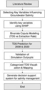
Groundwater salinization poses a critical threat to freshwater security in coastal regions, particularly under intensified extraction and evolving hydroclimatic conditions. This study examines the spatial and temporal evolution of salinity in the lower Chao Phraya River Basin during 2008 and 2020 using a multi-method machine learning framework. SHAP-based feature attribution analysis identified groundwater extraction as the most influential driver of salinity dynamics. A Gaussian copula model was employed to quantify the conditional probability of salinity threshold exceedance under varying extraction pressures, capturing nonlinear dependence structures between total dissolved solids (TDS) and groundwater extraction. A Graph Neural Network (GNN) model was developed to simulate TDS concentrations at 212 monitoring stations, demonstrating high predictive performance across both periods. To translate model outputs into actionable insights, a scenario-based Decision Support System (DSS) was implemented, enabling interactive visualization of salinity risk zones under 20% and 40% increases in groundwater withdrawal. Results reveal a pronounced expansion of high-salinity areas over time, largely driven by anthropogenic factors. By fusing explainable machine learning with probabilistic analysis and decision support, this framework provides a novel, scalable tool for real-time groundwater salinity risk assessment and supports evidence-based management in data-scarce coastal aquifers.
期刊介绍:
Environmental Monitoring and Assessment emphasizes technical developments and data arising from environmental monitoring and assessment, the use of scientific principles in the design of monitoring systems at the local, regional and global scales, and the use of monitoring data in assessing the consequences of natural resource management actions and pollution risks to man and the environment.

 求助内容:
求助内容: 应助结果提醒方式:


