Improved soil moisture mapping using an integrated cyclic modeling and bias correction approach
IF 4.5
Q2 ENVIRONMENTAL SCIENCES
Remote Sensing Applications-Society and Environment
Pub Date : 2025-09-29
DOI:10.1016/j.rsase.2025.101741
引用次数: 0
Abstract
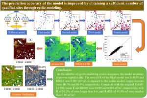
Soil moisture (SM) is crucial for climate change, crop growth estimation, and environmental hazard monitoring. Existing SM products often have low spatial resolution, limiting their use in local-scale studies. While various machine learning (ML) methods have been applied to downscale SM, few studies have explored multiple cyclic modeling or improved downscaling accuracy by recycling qualified stations. In this study, we performed quality control and bias correction on data from the International Soil Moisture Network (ISMN) stations. We obtained qualified sites by cyclic modeling using an extreme gradient boosting (XGBoost) regression model. The predicted bias from cyclic modeling was combined with dynamic environmental variables to correct errors at unqualified sites. Finally, a surface (0–5 cm) soil moisture product with a temporal and spatial resolution of 500 m/day was produced: (1) the XGBoost model described the relationship between SM and environmental variables well, achieving a correlation coefficient (R) of 0.98 and a root mean square error (RMSE) of 0.007 m3/m3 (2) The generated 500 m SM data was comparable to the Soil Moisture Active Passive Level 4 (SMAP-L4) SM data, with 83.2 % of the 1996 points having R > 0.6. The downscaling accuracy is improved by robust cyclic modeling and bias correction techniques, with R, RMSE, and mean absolute error (MAE) improved by 6.5 %, 9.3 %, and 9.6 %, respectively, over single-shot modeling. The estimated results of the surface layer (0–5 cm) soil moisture at 500 m/day can supplement the regional soil moisture database and provide ideas for downscaling soil moisture research.
利用综合循环建模和偏差校正方法改进土壤湿度制图
土壤湿度对气候变化、作物生长预测和环境危害监测至关重要。现有的SM产品通常具有较低的空间分辨率,限制了它们在局部尺度研究中的应用。虽然各种机器学习(ML)方法已经应用于缩小尺度的SM,但很少有研究探索多次循环建模或通过回收合格的站来提高缩小精度。在本研究中,我们对国际土壤湿度网络(ISMN)站点的数据进行了质量控制和偏差校正。我们使用极端梯度增强(XGBoost)回归模型通过循环建模获得了合格的位点。将循环模型的预测偏差与动态环境变量相结合,对不合格地点的误差进行校正。最后,生成了一个时空分辨率为500 m/d的地表(0-5 cm)土壤湿度产品:(1)XGBoost模型很好地描述了土壤湿度与环境变量之间的关系,相关系数(R)为0.98,均方根误差(RMSE)为0.007 m3/m3;(2)生成的500 m土壤湿度数据与土壤湿度主动被动4级(SMAP-L4)土壤湿度数据相当,1996年83.2%的点R >; 0.6。鲁棒循环建模和偏差校正技术提高了降尺度精度,与单次建模相比,R、RMSE和平均绝对误差(MAE)分别提高了6.5%、9.3%和9.6%。500 m/d下的表层(0 ~ 5 cm)土壤水分估算结果可以补充区域土壤水分数据库,为土壤水分降尺度研究提供思路。
本文章由计算机程序翻译,如有差异,请以英文原文为准。
求助全文
约1分钟内获得全文
求助全文
来源期刊

CiteScore
8.00
自引率
8.50%
发文量
204
审稿时长
65 days
期刊介绍:
The journal ''Remote Sensing Applications: Society and Environment'' (RSASE) focuses on remote sensing studies that address specific topics with an emphasis on environmental and societal issues - regional / local studies with global significance. Subjects are encouraged to have an interdisciplinary approach and include, but are not limited by: " -Global and climate change studies addressing the impact of increasing concentrations of greenhouse gases, CO2 emission, carbon balance and carbon mitigation, energy system on social and environmental systems -Ecological and environmental issues including biodiversity, ecosystem dynamics, land degradation, atmospheric and water pollution, urban footprint, ecosystem management and natural hazards (e.g. earthquakes, typhoons, floods, landslides) -Natural resource studies including land-use in general, biomass estimation, forests, agricultural land, plantation, soils, coral reefs, wetland and water resources -Agriculture, food production systems and food security outcomes -Socio-economic issues including urban systems, urban growth, public health, epidemics, land-use transition and land use conflicts -Oceanography and coastal zone studies, including sea level rise projections, coastlines changes and the ocean-land interface -Regional challenges for remote sensing application techniques, monitoring and analysis, such as cloud screening and atmospheric correction for tropical regions -Interdisciplinary studies combining remote sensing, household survey data, field measurements and models to address environmental, societal and sustainability issues -Quantitative and qualitative analysis that documents the impact of using remote sensing studies in social, political, environmental or economic systems
 求助内容:
求助内容: 应助结果提醒方式:


