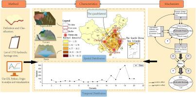
The spatiotemporal distribution and influencing mechanism of China's hydraulic heritage sites
IF 7
1区 经济学
Q1 DEVELOPMENT STUDIES
引用次数: 0
Abstract
Hydraulic heritage is important carriers of human civilization. Furthermore, hydraulic heritage in China is a typical representative of world hydroculture. Based on cultural heritage lists of different grades, 1733 China's hydraulic heritage sites (CHHS) were screened out and divided into 4 categories, and spatial analysis methods were used to study the spatial-temporal distribution of CHHS since the Neolithic Age. The results are as follows: (1) CHHS show a weak centralization trend and fluctuating growth over time. Most of these sites developed during three unification periods (Qin and Han Dynasties, Sui and Tang Dynasties, Song, Yuan, Ming and Qing Dynasties) in terms of quantity and type; 76.80 % of CHHS is associated with these periods. (2) CHHS are spatially distributed in a quadrilateral pattern, with 85.75 % located in the core area and buffer of the quadrilateral, for which Beijing, Hangzhou, Chengdu, and Guangzhou are the vertices; the distribution of various types and periods of CHHS also conform to this pattern. (3) The quadrilateral pattern has significant natural, political and economic characteristics, as it is located on the second and third steps of the terrain; situated in the middle and lower reaches of the Yangtze River Basin (YZB) and the Yellow River Basin (YWB), and other eastern basins; concentrated in warm and humid agricultural areas; corresponded to the layout of basic economic zones and political centers in ancient China. The distribution of hydraulic heritage sites is directly related to the construction and preservation of hydraulic projects and is affected by the combined action of political, economic, natural, and technological factors. Exploring the distribution law of CHHS can provide a reference for protecting world hydraulic heritage.
中国水利遗产地时空分布及其影响机制
水利遗产是人类文明的重要载体。此外,中国的水利遗产是世界水利文化的典型代表。基于不同等级的文化遗产名录,筛选出1733个中国水工遗产地,并将其分为4类,采用空间分析方法研究新石器时代以来水工遗产地的时空分布。结果表明:(1)CHHS呈弱集中化趋势,随时间呈波动增长;这些遗址在数量和类型上大多发展于三个统一时期(秦汉、隋唐、宋、元、明、清);76.80%的CHHS与这些时期有关。(2)城市卫生系统空间分布呈四边形格局,以北京、杭州、成都、广州为顶点,85.75%的城市卫生系统位于四边形的核心区和缓冲区内;不同类型和时期的CHHS分布也符合这一格局。(3)四边形格局位于地形的第二级和第三级,具有显著的自然、政治和经济特征;位于长江中下游、黄河流域和其他东部流域;集中在温暖潮湿的农业区;与中国古代基本经济区和政治中心的布局相对应。水利遗产地的分布直接关系到水利工程的建设和保存,受到政治、经济、自然、技术等多种因素的综合影响。探索CHHS分布规律,可为世界水利遗产保护提供参考。
本文章由计算机程序翻译,如有差异,请以英文原文为准。
求助全文
约1分钟内获得全文
求助全文
来源期刊
Habitat International
Multiple-
CiteScore
10.50
自引率
10.30%
发文量
151
审稿时长
38 days
期刊介绍:
Habitat International is dedicated to the study of urban and rural human settlements: their planning, design, production and management. Its main focus is on urbanisation in its broadest sense in the developing world. However, increasingly the interrelationships and linkages between cities and towns in the developing and developed worlds are becoming apparent and solutions to the problems that result are urgently required. The economic, social, technological and political systems of the world are intertwined and changes in one region almost always affect other regions.
 求助内容:
求助内容: 应助结果提醒方式:


