Location intelligence unveils seasonal spatiotemporal pattern shifts of habitat use and selection by cattle across a South Texas coastal landscape infested with Rhipicephalus microplus
IF 1.7
Q3 PARASITOLOGY
Current research in parasitology & vector-borne diseases
Pub Date : 2025-01-01
DOI:10.1016/j.crpvbd.2025.100322
引用次数: 0
Abstract
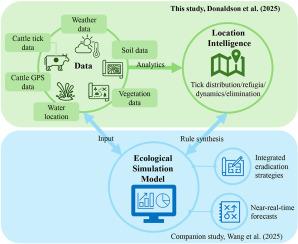
Knowledge gaps on the dynamics of cattle fever tick-cattle-habitat-climate interactions in South Texas and their influence on the efficacy of treatments to eliminate infestations with the Rhipicephalus (Boophilus) microplus prevent optimal interventions by the Cattle Fever Tick Eradication Program (CFTEP). The CFTEP has been operating in the USA since 1907. This study applied the concept of location intelligence to examine movement, habitat use and selection by cattle in a highly heterogeneous coastal landscape infested with R. microplus. Cattle interface with white-tailed deer and nilgai, which are alternate wildlife hosts of R. microplus, in this unique South Texas landscape. Location intelligence data obtained from GPS collars placed on steers between August and December 2019 that were treated as part of the protocol to eradicate R. microplus were used to track their movement in the tick-infested rangeland of the Laguna Atascosa National Wildlife Refuge. GIS spatial analyses were conducted to determine time-of-day (morning, midday, evening, midnight), and seasonal differences in: (i) distance of cattle movements; (ii) cattle habitat use and selection; (iii) spatial spread of cattle; and (iv) distance to closest watering site. Cattle movement patterns, habitat use and selection, spatial spread, and distance to closest watering sites were significantly different between the summer and autumn periods. These variables were also significantly different by time-of-day periods within and between seasonal periods. Habitat use and selection by steers are discussed in the context of range sites and vegetation types. Nine ixodid tick species were documented through the inspection of hosts (cattle, nilgai, and white-tailed deer). Rhipicephalus microplus was collected from white-tailed deer and nilgai during cull hunts, as well as from project cattle that missed one anti-tick treatment due to adverse weather conditions. Tick-host-habitat-climate interactions involving cattle and wildlife, future grazing strategies for anti-tick treated cattle, and potential impacts of tick-refugia are discussed in the context of location intelligence. Spatiotemporal patterns of cattle habitat use and selection across an infested coastal landscape in South Texas revealed by location intelligence could inform adaptive operations of the CFTEP to keep the USA free of R. microplus.
位置情报揭示了南德克萨斯州沿海地区牛的栖息地使用和选择的季节性时空模式变化
南德克萨斯州牛热蜱-牛-栖息地-气候相互作用的动态知识差距及其对消除微鼻头虫(Boophilus)侵染的治疗效果的影响阻碍了牛热蜱根除计划(CFTEP)的最佳干预措施。CFTEP自1907年以来一直在美国运营。本研究应用位置智能的概念,考察了牛在一个高度异质的沿海景观中移动、栖息地利用和选择。牛与白尾鹿和nilgai接触,它们是R. microplus的交替野生宿主,在这独特的南德克萨斯州景观中。2019年8月至12月期间,从安装在方向盘上的GPS项圈获得的位置情报数据被用于跟踪它们在拉古纳·阿塔斯科萨国家野生动物保护区蜱虫肆虐的牧场上的活动,这些数据被视为根除微红尾虫协议的一部分。进行GIS空间分析以确定一天中的时间(早上、中午、晚上、午夜)和季节差异:(i)牛的移动距离;(ii)牛的生境使用及选择;(iii)牛的空间分布;(四)到最近浇水地点的距离。牛的运动模式、生境利用和选择、空间分布、到最近水源地的距离在夏季和秋季之间存在显著差异。这些变量在季节内和季节之间的不同时段也有显著差异。本文在不同的范围和植被类型的背景下讨论了鹿群对栖息地的利用和选择。通过对宿主(牛、nilgai和白尾鹿)的检查,记录了9种蜱虫。在扑杀期间,从白尾鹿和nilgai以及由于恶劣天气条件而错过一次抗蜱虫治疗的项目牛身上收集了微型鼻头虫。在位置情报的背景下,讨论了蜱-宿主-栖息地-气候的相互作用,包括牛和野生动物,抗蜱治疗牛的未来放牧策略,以及蜱避难所的潜在影响。位置情报揭示了南德克萨斯州沿海地区牛的栖息地利用和选择的时空格局,可以为CFTEP的适应性操作提供信息,以使美国免受微褐蝽的侵袭。
本文章由计算机程序翻译,如有差异,请以英文原文为准。
求助全文
约1分钟内获得全文
求助全文

 求助内容:
求助内容: 应助结果提醒方式:


