{"title":"Mapping four decades of lake chlorophyll-a across a continental watershed: A dataset for the lake winnipeg basin (1984-2023).","authors":"Sassan Mohammady, Irena F Creed","doi":"10.1016/j.dib.2025.112035","DOIUrl":null,"url":null,"abstract":"<p><p>We present a standardized pan-watershed dataset of annual chlorophyll-a concentration (Chl-a) in 27,313 lakes (≥ 10 ha) draining into Lake Winnipeg, Canada, spanning 1984-2023. Lake polygons from HydroLAKES were integrated with Landsat 5/7/8 Collection 2 imagery processed in Google Earth Engine (GEE) using a reproducible workflow that (1) filters July-October scenes (peak phytoplankton biomass season), (2) masks non-water pixels from each scene, (3) converts Landsat digital numbers to surface reflectance values, (4) applies a cross-sensor Chl-a retrieval model calibrated against in-situ samples, (5) calculates the spatial mean of Chl-a in each lake for each scene, and (6) calculates the median value of all spatial-mean values per lake per year. Outputs include per-lake annual Chl-a provided as both natural-log and back-transformed Chl-a (µg L⁻¹) plus annual trophic state classes delivered in an Excel workbook and two geodatabases for mapping. The accompanying annotated GEE and R codes, input lake boundaries, and documentation enable transparent reuse and straightforward adaptation to other regions, time periods, or sensors. This resource fills a critical monitoring gap for an agriculturally influenced, bloom-prone continental watershed and supports research and management by establishing productivity baselines, detecting departures from historical conditions, and assessing bloom timing at scales relevant to decision-making. All data, inputs, and code are openly available via Zenodo.</p>","PeriodicalId":10973,"journal":{"name":"Data in Brief","volume":"62 ","pages":"112035"},"PeriodicalIF":1.4000,"publicationDate":"2025-09-11","publicationTypes":"Journal Article","fieldsOfStudy":null,"isOpenAccess":false,"openAccessPdf":"https://www.ncbi.nlm.nih.gov/pmc/articles/PMC12477918/pdf/","citationCount":"0","resultStr":null,"platform":"Semanticscholar","paperid":null,"PeriodicalName":"Data in Brief","FirstCategoryId":"1085","ListUrlMain":"https://doi.org/10.1016/j.dib.2025.112035","RegionNum":0,"RegionCategory":null,"ArticlePicture":[],"TitleCN":null,"AbstractTextCN":null,"PMCID":null,"EPubDate":"2025/10/1 0:00:00","PubModel":"eCollection","JCR":"Q3","JCRName":"MULTIDISCIPLINARY SCIENCES","Score":null,"Total":0}
引用次数: 0
Abstract
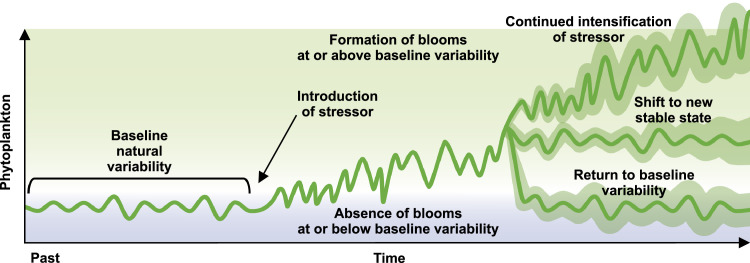
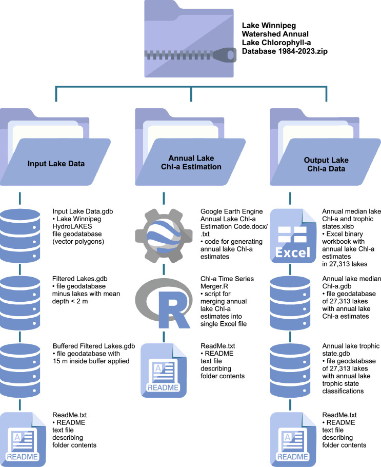
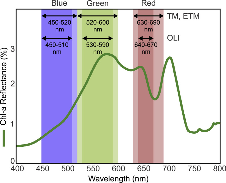
We present a standardized pan-watershed dataset of annual chlorophyll-a concentration (Chl-a) in 27,313 lakes (≥ 10 ha) draining into Lake Winnipeg, Canada, spanning 1984-2023. Lake polygons from HydroLAKES were integrated with Landsat 5/7/8 Collection 2 imagery processed in Google Earth Engine (GEE) using a reproducible workflow that (1) filters July-October scenes (peak phytoplankton biomass season), (2) masks non-water pixels from each scene, (3) converts Landsat digital numbers to surface reflectance values, (4) applies a cross-sensor Chl-a retrieval model calibrated against in-situ samples, (5) calculates the spatial mean of Chl-a in each lake for each scene, and (6) calculates the median value of all spatial-mean values per lake per year. Outputs include per-lake annual Chl-a provided as both natural-log and back-transformed Chl-a (µg L⁻¹) plus annual trophic state classes delivered in an Excel workbook and two geodatabases for mapping. The accompanying annotated GEE and R codes, input lake boundaries, and documentation enable transparent reuse and straightforward adaptation to other regions, time periods, or sensors. This resource fills a critical monitoring gap for an agriculturally influenced, bloom-prone continental watershed and supports research and management by establishing productivity baselines, detecting departures from historical conditions, and assessing bloom timing at scales relevant to decision-making. All data, inputs, and code are openly available via Zenodo.
期刊介绍:
Data in Brief provides a way for researchers to easily share and reuse each other''s datasets by publishing data articles that: -Thoroughly describe your data, facilitating reproducibility. -Make your data, which is often buried in supplementary material, easier to find. -Increase traffic towards associated research articles and data, leading to more citations. -Open up doors for new collaborations. Because you never know what data will be useful to someone else, Data in Brief welcomes submissions that describe data from all research areas.

 求助内容:
求助内容: 应助结果提醒方式:


