{"title":"Semi-automated multi-criteria filtering of building footprints for enhanced Wildland-Urban Interface mapping in mainland Portugal.","authors":"Bruno Barbosa, Sandra Oliveira, Jorge Rocha","doi":"10.1016/j.dib.2025.112055","DOIUrl":null,"url":null,"abstract":"<p><p>The expansion of the Wildland-Urban Interface (WUI) demands precise mapping to effectively mitigate wildfire risk. However, the absence of national building footprint databases presents a significant challenge. This study, focused on mainland Portugal, proposes a semi-automated, multi-criteria filtering framework to refine global open-source building datasets-specifically Microsoft's Global Building Footprints. The method integrates regional adaptability and spatial metrics such as area thresholds and proximity analyses, using Portugal's official Geographic Buildings Location Database as a reference. The framework prioritizes residential structures by excluding anomalies-such as industrial facilities, photovoltaic arrays, and transmission lines-through dynamically adjusted thresholds at various administrative levels (e.g., municipal and NUTS-2). The filtering process reduced the number of building footprints from approximately 5.6 million to around 3.0 million. We mapped the WUI across Portugal using both the original dataset (WUI_MSB) and the filtered dataset (WUI_MSB_F) to compare outcomes. The WUI was classified into <i>Intermix</i> and <i>Interface</i> types. Buildings that did not meet the minimum criteria to be considered part of the WUI were categorized based on their density: very low, low, medium, or high. The original WUI_MSB covered a total area of 13,177 km², representing approximately 15% of mainland Portugal. After applying the filtering framework, the WUI_MSB_F area was reduced by 49%, totaling 8,327 km². The workflow-implemented using Python scripting and ArcGIS Pro-is scalable for national-level applications. These experimental results highlight the importance of region-specific adjustments and demonstrate how this methodology can support policymakers in identifying and prioritizing context-specific exposed communities. By enhancing the reliability of open datasets, this approach offers a reproducible tool for wildfire resilience planning, particularly in data-scarce regions.</p>","PeriodicalId":10973,"journal":{"name":"Data in Brief","volume":"62 ","pages":"112055"},"PeriodicalIF":1.4000,"publicationDate":"2025-09-15","publicationTypes":"Journal Article","fieldsOfStudy":null,"isOpenAccess":false,"openAccessPdf":"https://www.ncbi.nlm.nih.gov/pmc/articles/PMC12477925/pdf/","citationCount":"0","resultStr":null,"platform":"Semanticscholar","paperid":null,"PeriodicalName":"Data in Brief","FirstCategoryId":"1085","ListUrlMain":"https://doi.org/10.1016/j.dib.2025.112055","RegionNum":0,"RegionCategory":null,"ArticlePicture":[],"TitleCN":null,"AbstractTextCN":null,"PMCID":null,"EPubDate":"2025/10/1 0:00:00","PubModel":"eCollection","JCR":"Q3","JCRName":"MULTIDISCIPLINARY SCIENCES","Score":null,"Total":0}
引用次数: 0
Abstract
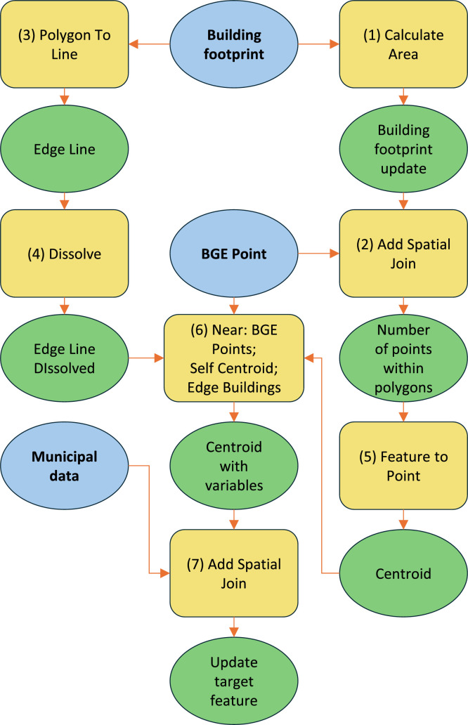
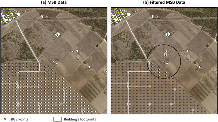
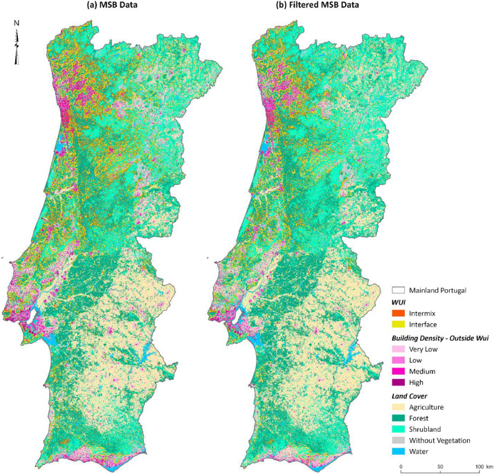
The expansion of the Wildland-Urban Interface (WUI) demands precise mapping to effectively mitigate wildfire risk. However, the absence of national building footprint databases presents a significant challenge. This study, focused on mainland Portugal, proposes a semi-automated, multi-criteria filtering framework to refine global open-source building datasets-specifically Microsoft's Global Building Footprints. The method integrates regional adaptability and spatial metrics such as area thresholds and proximity analyses, using Portugal's official Geographic Buildings Location Database as a reference. The framework prioritizes residential structures by excluding anomalies-such as industrial facilities, photovoltaic arrays, and transmission lines-through dynamically adjusted thresholds at various administrative levels (e.g., municipal and NUTS-2). The filtering process reduced the number of building footprints from approximately 5.6 million to around 3.0 million. We mapped the WUI across Portugal using both the original dataset (WUI_MSB) and the filtered dataset (WUI_MSB_F) to compare outcomes. The WUI was classified into Intermix and Interface types. Buildings that did not meet the minimum criteria to be considered part of the WUI were categorized based on their density: very low, low, medium, or high. The original WUI_MSB covered a total area of 13,177 km², representing approximately 15% of mainland Portugal. After applying the filtering framework, the WUI_MSB_F area was reduced by 49%, totaling 8,327 km². The workflow-implemented using Python scripting and ArcGIS Pro-is scalable for national-level applications. These experimental results highlight the importance of region-specific adjustments and demonstrate how this methodology can support policymakers in identifying and prioritizing context-specific exposed communities. By enhancing the reliability of open datasets, this approach offers a reproducible tool for wildfire resilience planning, particularly in data-scarce regions.
期刊介绍:
Data in Brief provides a way for researchers to easily share and reuse each other''s datasets by publishing data articles that: -Thoroughly describe your data, facilitating reproducibility. -Make your data, which is often buried in supplementary material, easier to find. -Increase traffic towards associated research articles and data, leading to more citations. -Open up doors for new collaborations. Because you never know what data will be useful to someone else, Data in Brief welcomes submissions that describe data from all research areas.

 求助内容:
求助内容: 应助结果提醒方式:


