Can optical water types be used as ecological indicators? Insights from a temperate estuary
IF 8.6
Q1 REMOTE SENSING
International journal of applied earth observation and geoinformation : ITC journal
Pub Date : 2025-09-28
DOI:10.1016/j.jag.2025.104880
引用次数: 0
Abstract
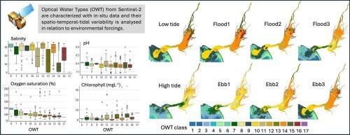
Monitoring water quality and understanding how estuarine ecosystems respond to environmental changes is essential to sustain their ecological integrity and associated ecosystem services. In this study, we demonstrate that Optical Water Type (OWT) classification from Sentinel-2 MSI can be used as a stand-alone product rather than an intermediate tool for algorithm refinement, providing valuable insights for environmental monitoring, using the Tagus Estuary as an example. In-situ measurements (Chl-a, temperature, salinity, pH, and dissolved oxygen) were employed to characterize environmental conditions associated with OWT classes and to analyse the spatio-temporal and tidal variability during 2017–2024. We identified distinct water quality profiles among groups of OWTs, which were associated with marine, transitional and riverine waters with different physico-chemical characteristics that were related to different environmental drivers. Tides significantly influenced the distribution of OWTs, with high and neap tides favouring the occurrence of clearer marine waters. Specific OWT classes emerged as indicators for key environmental processes, including marine water intrusion, freshwater inputs and phytoplankton-rich waters. Time-series analysis revealed a trend of increasing marine waters inside the estuary alongside interannual variability driven by hydro-climatic forcings. Our findings highlight OWT classification as a valuable stand-alone satellite product for water quality monitoring, providing a powerful and scalable tool for estuarine science, policy, and management.
光学水类型可以作为生态指标吗?来自温带河口的洞察
监测水质和了解河口生态系统如何应对环境变化对于维持其生态完整性和相关的生态系统服务至关重要。在本研究中,我们以塔霍斯河口为例,证明了Sentinel-2 MSI的光学水类型(OWT)分类可以作为一个独立的产品而不是算法改进的中间工具,为环境监测提供了有价值的见解。采用原位测量(Chl-a、温度、盐度、pH和溶解氧)表征了与wt类别相关的环境条件,并分析了2017-2024年wt类别的时空和潮汐变化。我们发现了不同组的不同水质剖面,这些水体与海洋、过渡和河流水域有关,具有不同的物理化学特征,这些特征与不同的环境驱动因素有关。潮汐显著地影响了wts的分布,大潮和小潮有利于出现更清澈的海水。具体的OWT类别成为关键环境过程的指标,包括海水入侵、淡水输入和富含浮游植物的水域。时间序列分析表明,在水文气候强迫的驱动下,河口内海水呈增加趋势,年际变化趋势明显。我们的研究结果突出了OWT分类作为水质监测的一个有价值的独立卫星产品,为河口科学、政策和管理提供了一个强大和可扩展的工具。
本文章由计算机程序翻译,如有差异,请以英文原文为准。
求助全文
约1分钟内获得全文
求助全文
来源期刊

International journal of applied earth observation and geoinformation : ITC journal
Global and Planetary Change, Management, Monitoring, Policy and Law, Earth-Surface Processes, Computers in Earth Sciences
CiteScore
12.00
自引率
0.00%
发文量
0
审稿时长
77 days
期刊介绍:
The International Journal of Applied Earth Observation and Geoinformation publishes original papers that utilize earth observation data for natural resource and environmental inventory and management. These data primarily originate from remote sensing platforms, including satellites and aircraft, supplemented by surface and subsurface measurements. Addressing natural resources such as forests, agricultural land, soils, and water, as well as environmental concerns like biodiversity, land degradation, and hazards, the journal explores conceptual and data-driven approaches. It covers geoinformation themes like capturing, databasing, visualization, interpretation, data quality, and spatial uncertainty.
 求助内容:
求助内容: 应助结果提醒方式:


