Convolutional neural networks for semantic segmentation of aerial images in land cover mapping of environmental protection areas
IF 4.5
Q2 ENVIRONMENTAL SCIENCES
Remote Sensing Applications-Society and Environment
Pub Date : 2025-09-23
DOI:10.1016/j.rsase.2025.101707
引用次数: 0
Abstract
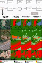
Environmental Protection Areas (EPAs) in Brazil are key legal instruments for conserving biodiversity, ensuring the sustainable use of natural resources, and supporting the socioeconomic development of local communities. Remote Sensing (RS) has emerged as a practical and cost-efficient alternative for monitoring these regions. In this context, advanced computational techniques - particularly Convolutional Neural Networks (CNNs) — have demonstrated strong performance in the semantic segmentation of RS imagery. This study proposes a low-cost and scalable methodology for land use and land cover mapping in the EPA-Petrópolis region (Rio de Janeiro), based on RGB images from Google Earth and CNN models. This work stands out by offering a low-cost and scalable methodology using RGB imagery from Google Earth, and by introducing the EpaPetroBR dataset–one of the first annotated semantic segmentation datasets focused on the Atlantic Forest biome. The SegNet and U-Net architectures were evaluated across four experimental scenarios. The best overall accuracy (0.87) was obtained in scenario 4, which employed U-Net with the Focal Loss function. Scenario 3, using U-Net with the cross-entropy loss function, achieved comparable accuracy (0.87) and the highest Jaccard Index (IoU) score (0.72). Despite these promising results, some classes — such as Exposed Soil — remained challenging, with F1-scores ranging from 0.31 to 0.52. The comparative analysis of loss functions indicated limited influence on overall performance, reinforcing the robustness of the U-Net architecture. The results highlight the potential of combining CNNs with freely available high-resolution imagery for environmental monitoring in tropical forest regions.
基于卷积神经网络的环境保护区土地覆盖制图航空影像语义分割
巴西的环境保护区(EPAs)是保护生物多样性、确保自然资源可持续利用和支持当地社区社会经济发展的关键法律工具。遥感(RS)已成为监测这些区域的一种实际和具有成本效益的替代方法。在这种情况下,先进的计算技术-特别是卷积神经网络(cnn) -在RS图像的语义分割中表现出了强大的性能。本研究基于谷歌Earth和CNN模型的RGB图像,提出了一种低成本和可扩展的方法,用于EPA-Petrópolis地区(里约热内卢de Janeiro)的土地利用和土地覆盖制图。这项工作的突出之处是,它提供了一种低成本、可扩展的方法,使用来自谷歌Earth的RGB图像,并引入了EpaPetroBR数据集——第一个专注于大西洋森林生物群落的注释语义分割数据集。在四个实验场景中对SegNet和U-Net架构进行了评估。采用带Focal Loss函数的U-Net方案4获得了最佳的总体精度(0.87)。场景3使用带有交叉熵损失函数的U-Net,获得了相当的准确率(0.87)和最高的Jaccard指数(IoU)得分(0.72)。尽管取得了这些令人鼓舞的成果,但一些课程(如暴露土壤)仍然具有挑战性,f1得分在0.31到0.52之间。损失函数的对比分析表明对整体性能的影响有限,增强了U-Net体系结构的鲁棒性。研究结果强调了将cnn与免费的高分辨率图像结合起来用于热带森林地区环境监测的潜力。
本文章由计算机程序翻译,如有差异,请以英文原文为准。
求助全文
约1分钟内获得全文
求助全文
来源期刊

CiteScore
8.00
自引率
8.50%
发文量
204
审稿时长
65 days
期刊介绍:
The journal ''Remote Sensing Applications: Society and Environment'' (RSASE) focuses on remote sensing studies that address specific topics with an emphasis on environmental and societal issues - regional / local studies with global significance. Subjects are encouraged to have an interdisciplinary approach and include, but are not limited by: " -Global and climate change studies addressing the impact of increasing concentrations of greenhouse gases, CO2 emission, carbon balance and carbon mitigation, energy system on social and environmental systems -Ecological and environmental issues including biodiversity, ecosystem dynamics, land degradation, atmospheric and water pollution, urban footprint, ecosystem management and natural hazards (e.g. earthquakes, typhoons, floods, landslides) -Natural resource studies including land-use in general, biomass estimation, forests, agricultural land, plantation, soils, coral reefs, wetland and water resources -Agriculture, food production systems and food security outcomes -Socio-economic issues including urban systems, urban growth, public health, epidemics, land-use transition and land use conflicts -Oceanography and coastal zone studies, including sea level rise projections, coastlines changes and the ocean-land interface -Regional challenges for remote sensing application techniques, monitoring and analysis, such as cloud screening and atmospheric correction for tropical regions -Interdisciplinary studies combining remote sensing, household survey data, field measurements and models to address environmental, societal and sustainability issues -Quantitative and qualitative analysis that documents the impact of using remote sensing studies in social, political, environmental or economic systems
 求助内容:
求助内容: 应助结果提醒方式:


