Geo-Mamba: A data-driven Mamba framework for spatiotemporal modeling with multi-source geographic factor integration
IF 8.6
Q1 REMOTE SENSING
International journal of applied earth observation and geoinformation : ITC journal
Pub Date : 2025-09-22
DOI:10.1016/j.jag.2025.104854
引用次数: 0
Abstract
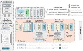
Earth science data exhibit inherent complexity characterized by heterogeneous spatiotemporal attributes, high collinearity among variables, and diverse input formats. Despite rapid advancements in deep learning, geographic modeling lacks unified frameworks for integrating heterogeneous spatiotemporal data and diverse factor types. While Mamba architecture has demonstrated efficiency in large language models, computer vision and remote sensing, its applicability to geographic modeling remains unexplored. This study introduces Geo-Mamba, a novel framework addressing these challenges through three key innovations. First, we propose a systematic geographical factor classification method that categorizes elements into dynamic, static, and categorical factors, enabling standardized integration of heterogeneous data within a unified paradigm. Second, we design a selective encoder module based on Mamba architecture that leverages its linear complexity and scanning mechanism to establish selective state spaces for geographical inputs, revealing intricate associations between diverse feature types. Third, we incorporate Kolmogorov-Arnold Network (KAN) layers as intermediate components replacing multilayer perceptron linear layers, enhancing numerical regression accuracy in geographical applications. Experimental validation across three tasks demonstrates Geo-Mamba’s effectiveness: in net ecosystem exchange modeling (R2 = 0.92, RMSE = 0.37 μmol·m–2·s–1), groundwater storage anomaly downscaling (R2 = 0.95, RMSE = 1.916 cm), and land cover classification (accuracy = 88.12 %, F1-Score = 84.27 %). These results confirm Geo-Mamba as an efficient unified framework for complex Earth science modeling, while establishing its viability for geographical data processing and factor integration.
Geo-Mamba:一个数据驱动的Mamba框架,用于多源地理因素集成的时空建模
地学数据具有时空属性异构、变量间高度共线性、输入格式多样等特点。尽管深度学习技术发展迅速,但地理建模缺乏统一的框架来整合异构时空数据和多种因素类型。虽然Mamba架构在大型语言模型、计算机视觉和遥感方面已经证明了效率,但它在地理建模方面的适用性仍有待探索。本研究介绍了Geo-Mamba,这是一个通过三个关键创新来解决这些挑战的新框架。首先,我们提出了一种系统的地理因素分类方法,该方法将元素分为动态、静态和分类因素,从而在统一的范式中实现异构数据的标准化集成。其次,我们设计了一个基于Mamba架构的选择性编码器模块,利用其线性复杂性和扫描机制为地理输入建立选择性状态空间,揭示不同特征类型之间的复杂关联。第三,我们将Kolmogorov-Arnold Network (KAN)层作为替代多层感知器线性层的中间组件,提高了地理应用中的数值回归精度。实验验证了Geo-Mamba在净生态系统交换建模(R2 = 0.92, RMSE = 0.37 μmol·m-2·s-1)、地下水储量异常降尺度(R2 = 0.95, RMSE = 1.916 cm)和土地覆盖分类(精度= 88.12%,F1-Score = 84.27%)方面的有效性。这些结果证实了Geo-Mamba是复杂地球科学建模的有效统一框架,同时建立了地理数据处理和因子整合的可行性。
本文章由计算机程序翻译,如有差异,请以英文原文为准。
求助全文
约1分钟内获得全文
求助全文
来源期刊

International journal of applied earth observation and geoinformation : ITC journal
Global and Planetary Change, Management, Monitoring, Policy and Law, Earth-Surface Processes, Computers in Earth Sciences
CiteScore
12.00
自引率
0.00%
发文量
0
审稿时长
77 days
期刊介绍:
The International Journal of Applied Earth Observation and Geoinformation publishes original papers that utilize earth observation data for natural resource and environmental inventory and management. These data primarily originate from remote sensing platforms, including satellites and aircraft, supplemented by surface and subsurface measurements. Addressing natural resources such as forests, agricultural land, soils, and water, as well as environmental concerns like biodiversity, land degradation, and hazards, the journal explores conceptual and data-driven approaches. It covers geoinformation themes like capturing, databasing, visualization, interpretation, data quality, and spatial uncertainty.
 求助内容:
求助内容: 应助结果提醒方式:


