{"title":"Integrating pollution indices, spatial interpolation, and machine learning for soil contamination analysis along the Zarqa River, Jordan","authors":"Osama Al-Qawasmeh, Habes Ghrefat","doi":"10.1007/s10661-025-14586-2","DOIUrl":null,"url":null,"abstract":"<div><p>This study assesses soil contamination along the Zarqa River (ZR) in Jordan by integrating pollution indices, geostatistical interpolation, and machine learning models. We collected 34 soil samples from agricultural lands within the study area. Samples were analyzed for Fe, Mn, Zn, Co, and Cr concentrations using atomic absorption spectroscopy (AAS). Organic matter (OM), soil texture, carbonate, pH, Fe₂O₃, Al₂O₃, and SiO₂ oxides were measured using standardized laboratory protocols. Elevation and slope were derived from a digital elevation model (DEM) with a spatial resolution of 12.5 m. The normalized difference vegetation index (NDVI) was applied to Landsat 8 OLI data. Pollution levels were assessed using the enrichment factor (EF), contamination factor (CF), and geoaccumulation index (Igeo). The results showed that Co exhibited the highest contamination potential, with average values of 5.3, 3.72, and 1.48 for EF, CF, and Igeo, respectively, indicating significant enrichment and considerable contamination. In contrast, Cr exhibited the lowest values across all indices, indicating a natural origin. Of the seven tested models, XGBoost demonstrated the highest predictive accuracy for Fe (<i>R</i><sup>2</sup> = 0.998). The decision tree and geographically weighted regression models also demonstrated robust performance for Zn, Mn, Cr, and Co. The integration of pollution indices, GIS, and machine learning models provided a high-resolution assessment of contamination hotspots. These findings provide practical implications for environmental monitoring, sustainable land-use planning, and soil pollution mitigation in the ZR basin.</p></div>","PeriodicalId":544,"journal":{"name":"Environmental Monitoring and Assessment","volume":"197 10","pages":""},"PeriodicalIF":3.0000,"publicationDate":"2025-09-22","publicationTypes":"Journal Article","fieldsOfStudy":null,"isOpenAccess":false,"openAccessPdf":"","citationCount":"0","resultStr":null,"platform":"Semanticscholar","paperid":null,"PeriodicalName":"Environmental Monitoring and Assessment","FirstCategoryId":"93","ListUrlMain":"https://link.springer.com/article/10.1007/s10661-025-14586-2","RegionNum":4,"RegionCategory":"环境科学与生态学","ArticlePicture":[],"TitleCN":null,"AbstractTextCN":null,"PMCID":null,"EPubDate":"","PubModel":"","JCR":"Q3","JCRName":"ENVIRONMENTAL SCIENCES","Score":null,"Total":0}
引用次数: 0
Abstract
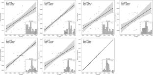
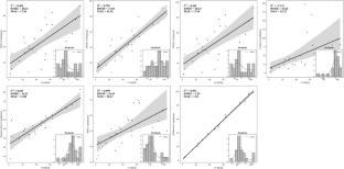
This study assesses soil contamination along the Zarqa River (ZR) in Jordan by integrating pollution indices, geostatistical interpolation, and machine learning models. We collected 34 soil samples from agricultural lands within the study area. Samples were analyzed for Fe, Mn, Zn, Co, and Cr concentrations using atomic absorption spectroscopy (AAS). Organic matter (OM), soil texture, carbonate, pH, Fe₂O₃, Al₂O₃, and SiO₂ oxides were measured using standardized laboratory protocols. Elevation and slope were derived from a digital elevation model (DEM) with a spatial resolution of 12.5 m. The normalized difference vegetation index (NDVI) was applied to Landsat 8 OLI data. Pollution levels were assessed using the enrichment factor (EF), contamination factor (CF), and geoaccumulation index (Igeo). The results showed that Co exhibited the highest contamination potential, with average values of 5.3, 3.72, and 1.48 for EF, CF, and Igeo, respectively, indicating significant enrichment and considerable contamination. In contrast, Cr exhibited the lowest values across all indices, indicating a natural origin. Of the seven tested models, XGBoost demonstrated the highest predictive accuracy for Fe (R2 = 0.998). The decision tree and geographically weighted regression models also demonstrated robust performance for Zn, Mn, Cr, and Co. The integration of pollution indices, GIS, and machine learning models provided a high-resolution assessment of contamination hotspots. These findings provide practical implications for environmental monitoring, sustainable land-use planning, and soil pollution mitigation in the ZR basin.
期刊介绍:
Environmental Monitoring and Assessment emphasizes technical developments and data arising from environmental monitoring and assessment, the use of scientific principles in the design of monitoring systems at the local, regional and global scales, and the use of monitoring data in assessing the consequences of natural resource management actions and pollution risks to man and the environment.

 求助内容:
求助内容: 应助结果提醒方式:


