Contribution of high-resolution remote sensing to spatial ecology of forest ecosystems at the single tree level: A systematic review
IF 4.5
Q2 ENVIRONMENTAL SCIENCES
Remote Sensing Applications-Society and Environment
Pub Date : 2025-09-17
DOI:10.1016/j.rsase.2025.101733
引用次数: 0
Abstract
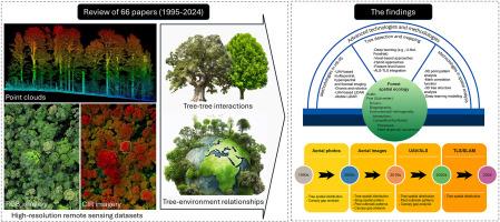
Forest spatial ecology investigates the complex relationships between spatial patterns and ecological processes, offering critical insights into forest ecosystem dynamics. This review synthesizes findings from 66 studies, highlighting the growing significance of high-resolution remote sensing (HR-RS) technologies in the field. HR-RS is particularly valuable for capturing tree–tree interactions and tree–environment relationships that are difficult to detect using traditional field methods, especially in large or densely vegetated forests. HR-RS datasets, including imagery and point clouds, enable spatially explicit measurements of individual trees, capturing both quantitative attributes (e.g., height, crown size) and qualitative characteristics (e.g., species, health status). Among the reviewed studies, 35 % employed aerial imagery to detect features such as canopy gaps, snags, and pest outbreaks, while 40 % utilized point pattern analysis to assess tree–tree ecological interactions. LiDAR was widely used for its ability to represent forest 3D structure and biophysical attributes. Notably, 45.5 % of the studies focused on tree–environment relationships, using HR-RS to map environmental variables such as soil moisture and microclimate conditions. However, advanced technologies such as multispectral and hyperspectral LiDAR remain underutilized, revealing a gap in current research. To advance forest spatial ecology, future studies should prioritize multisensor data fusion, longitudinal UAV–LiDAR monitoring, and advanced 3D spatial analyses. The integration of machine learning and deep learning techniques will also be essential for improving tree classification and detecting spatial patterns, ultimately deepening our understanding of forest ecological processes.
单树水平高分辨率遥感对森林生态系统空间生态学的贡献:系统综述
森林空间生态学研究了空间格局和生态过程之间的复杂关系,为森林生态系统动力学提供了重要的见解。本综述综合了66项研究的结果,强调了高分辨率遥感技术在该领域日益重要的意义。HR-RS在捕捉树与树之间的相互作用和树与环境之间的关系方面特别有价值,这是用传统的野外方法难以探测到的,特别是在大片或茂密的森林中。包括图像和点云在内的HR-RS数据集能够在空间上明确测量单株树木,捕获数量属性(如高度、树冠大小)和质量特征(如物种、健康状况)。在回顾的研究中,35%的研究使用航空图像来检测树冠间隙、障碍和害虫爆发等特征,而40%的研究使用点模式分析来评估树与树的生态相互作用。激光雷达因其能够表征森林三维结构和生物物理属性而得到广泛应用。值得注意的是,45.5%的研究集中在树木与环境的关系上,使用HR-RS来绘制环境变量,如土壤湿度和小气候条件。然而,多光谱和高光谱激光雷达等先进技术仍未得到充分利用,显示出当前研究的空白。为了推进森林空间生态,未来的研究应优先考虑多传感器数据融合、纵向无人机-激光雷达监测和先进的三维空间分析。机器学习和深度学习技术的整合对于改进树木分类和检测空间模式也至关重要,最终加深我们对森林生态过程的理解。
本文章由计算机程序翻译,如有差异,请以英文原文为准。
求助全文
约1分钟内获得全文
求助全文
来源期刊

CiteScore
8.00
自引率
8.50%
发文量
204
审稿时长
65 days
期刊介绍:
The journal ''Remote Sensing Applications: Society and Environment'' (RSASE) focuses on remote sensing studies that address specific topics with an emphasis on environmental and societal issues - regional / local studies with global significance. Subjects are encouraged to have an interdisciplinary approach and include, but are not limited by: " -Global and climate change studies addressing the impact of increasing concentrations of greenhouse gases, CO2 emission, carbon balance and carbon mitigation, energy system on social and environmental systems -Ecological and environmental issues including biodiversity, ecosystem dynamics, land degradation, atmospheric and water pollution, urban footprint, ecosystem management and natural hazards (e.g. earthquakes, typhoons, floods, landslides) -Natural resource studies including land-use in general, biomass estimation, forests, agricultural land, plantation, soils, coral reefs, wetland and water resources -Agriculture, food production systems and food security outcomes -Socio-economic issues including urban systems, urban growth, public health, epidemics, land-use transition and land use conflicts -Oceanography and coastal zone studies, including sea level rise projections, coastlines changes and the ocean-land interface -Regional challenges for remote sensing application techniques, monitoring and analysis, such as cloud screening and atmospheric correction for tropical regions -Interdisciplinary studies combining remote sensing, household survey data, field measurements and models to address environmental, societal and sustainability issues -Quantitative and qualitative analysis that documents the impact of using remote sensing studies in social, political, environmental or economic systems
 求助内容:
求助内容: 应助结果提醒方式:


