Optimised multi-hierarchical feature fusion with multi-kernel CNN and spectral-spatial convolutions for remote sensing image classification
IF 4.5
Q2 ENVIRONMENTAL SCIENCES
Remote Sensing Applications-Society and Environment
Pub Date : 2025-09-11
DOI:10.1016/j.rsase.2025.101727
引用次数: 0
Abstract
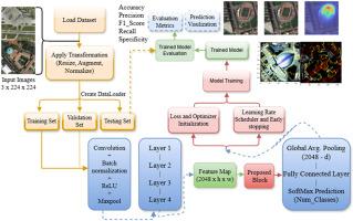
Remote sensing image classification is a central process in the interpretation of Earth observation data for applications such as land use mapping, environmental monitoring, and urban planning. Despite significant progress brought about by deep learning, particularly Convolutional Neural Networks (CNNs), existing models are prone to failing to represent complex spatial patterns, multi-scale object variation, and rich spectral dependencies characteristic of high-resolution remote sensing images. In addition, most models are suffering from greater computational complexity and poor generalisation on diverse datasets. To address these issues, we propose an Optimised Multi-Hierarchical Feature Fusion Framework, a deep learning model that integrates multi-kernel convolution, spectral-spatial depthwise convolution, and residual learning into a ResNet-50 backbone. The model learns a rich set of spatial textures and spectral features at different hierarchical layers, leading to enhanced feature representation and classification robustness. We evaluated the proposed method on six remote sensing datasets: AID, EUROSAT, NWPU-RESISC45, RSSCN7, UC Merced, and WHU-RS19 with standard performance metrics like accuracy, precision, recall, specificity, and F1-score. The proposed method achieved an average accuracy of 99.00 % for AID, 99.51 % for EUROSAT, 99.56 % for RESISC45, 95.71 % for RSSCN7, 99.14 % for UC Merced, and 95.79 % for WHU-RS19. Moreover, qualitative visualisation techniques such as Class Activation Mapping (CAM) and LIME were employed to provide explanations of model decisions by identifying the most influential image regions to the predictions. These visual explanations confirmed that the model is based on semantically meaningful regions, further improving its interpretability and trustworthiness. The superior accuracy and robust performance on multiple datasets verify the efficiency and generalisation ability of the designed model, indicating it is a strong candidate for practical remote sensing classification tasks. https://github.com/chiagoziemchima/Multi-Hierarchical-Feature-Fusion-/tree/main.
基于多核CNN和光谱空间卷积的优化多层特征融合遥感图像分类
遥感图像分类是土地利用制图、环境监测和城市规划等应用对地球观测数据进行解释的核心过程。尽管深度学习,特别是卷积神经网络(cnn)带来了重大进展,但现有模型容易无法表征高分辨率遥感图像复杂的空间格局、多尺度目标变化和丰富的光谱依赖性等特征。此外,大多数模型在不同的数据集上都存在较大的计算复杂性和较差的泛化。为了解决这些问题,我们提出了一个优化的多层特征融合框架,这是一个将多核卷积、频谱空间深度卷积和残差学习集成到ResNet-50骨干网中的深度学习模型。该模型在不同层次层学习丰富的空间纹理和光谱特征,增强了特征表示和分类鲁棒性。我们在六个遥感数据集(AID、EUROSAT、NWPU-RESISC45、RSSCN7、UC Merced和WHU-RS19)上对所提出的方法进行了评估,包括准确度、精密度、召回率、特异性和f1评分等标准性能指标。所提出的方法在AID、EUROSAT、RESISC45、RSSCN7、UC Merced和WHU-RS19的平均准确率分别为99.00%、99.51%、99.56%、95.71%和99.14%。此外,定性可视化技术,如类激活映射(CAM)和石灰被用来通过识别最具影响力的图像区域的预测提供模型决策的解释。这些可视化的解释证实了该模型是基于语义上有意义的区域,进一步提高了其可解释性和可信度。在多数据集上优异的精度和鲁棒性验证了所设计模型的有效性和泛化能力,表明该模型是实际遥感分类任务的有力候选者。https://github.com/chiagoziemchima/Multi-Hierarchical-Feature-Fusion-/tree/main。
本文章由计算机程序翻译,如有差异,请以英文原文为准。
求助全文
约1分钟内获得全文
求助全文
来源期刊

CiteScore
8.00
自引率
8.50%
发文量
204
审稿时长
65 days
期刊介绍:
The journal ''Remote Sensing Applications: Society and Environment'' (RSASE) focuses on remote sensing studies that address specific topics with an emphasis on environmental and societal issues - regional / local studies with global significance. Subjects are encouraged to have an interdisciplinary approach and include, but are not limited by: " -Global and climate change studies addressing the impact of increasing concentrations of greenhouse gases, CO2 emission, carbon balance and carbon mitigation, energy system on social and environmental systems -Ecological and environmental issues including biodiversity, ecosystem dynamics, land degradation, atmospheric and water pollution, urban footprint, ecosystem management and natural hazards (e.g. earthquakes, typhoons, floods, landslides) -Natural resource studies including land-use in general, biomass estimation, forests, agricultural land, plantation, soils, coral reefs, wetland and water resources -Agriculture, food production systems and food security outcomes -Socio-economic issues including urban systems, urban growth, public health, epidemics, land-use transition and land use conflicts -Oceanography and coastal zone studies, including sea level rise projections, coastlines changes and the ocean-land interface -Regional challenges for remote sensing application techniques, monitoring and analysis, such as cloud screening and atmospheric correction for tropical regions -Interdisciplinary studies combining remote sensing, household survey data, field measurements and models to address environmental, societal and sustainability issues -Quantitative and qualitative analysis that documents the impact of using remote sensing studies in social, political, environmental or economic systems
 求助内容:
求助内容: 应助结果提醒方式:


