{"title":"Stability of road cut slopes along NH-44 in the Kashmir Himalayas: a study using slope mass rating and kinematic analysis","authors":"Riyaz Ahmad Mir, Zahid Habib, Kainat Aziz","doi":"10.1007/s12518-025-00637-3","DOIUrl":null,"url":null,"abstract":"<div><p>This study assesses the slope stability of various road cut slopes along National Highway (NH-44), which runs from Jawahar Tunnel Banihal to Ramban in the Kashmir Himalaya, India. Frequent landslides along NH-44 disrupt infrastructure, transportation, and the region’s development and economy. Ongoing road widening, tunneling activities, and heavy rainfall during the monsoon season lead to regular slope failures and blockages of NH-44. A comprehensive field survey was conducted to collect lithological and structural data for rock mass characterization, kinematic analysis, and slope stability evaluation. A total of 27 road cut slopes were analyzed for Rock Mass Rating (RMR) and Slope Mass Rating (SMR), while 48 sites were assessed for kinematic analysis. The area was divided into four domains (D-1, D-2, D-3, and D-4) based on major structural discontinuities for detailed study and analysis. The RMR values ranged from 8 to 82 (Very Poor to Very Good), while SMR values ranged from 7 to 82 (Very Bad to Very Good). Kinematic analysis identified that most failures are due to planar and wedge failures, with some toppling failures. The slopes, ranging from moderately stable to unstable, are prone to instability and collapse, especially due to changes in slope morphometry and frequent rainfall. The region lies within a tectonically active zone, making the slopes inherently unstable. This study’s integrated approach provides valuable insights into hazard mitigation, highlighting critical failure-prone areas and supporting better planning for infrastructure and sustainable development in the Himalayan region.</p></div>","PeriodicalId":46286,"journal":{"name":"Applied Geomatics","volume":"17 4","pages":"627 - 654"},"PeriodicalIF":2.3000,"publicationDate":"2025-06-28","publicationTypes":"Journal Article","fieldsOfStudy":null,"isOpenAccess":false,"openAccessPdf":"","citationCount":"0","resultStr":null,"platform":"Semanticscholar","paperid":null,"PeriodicalName":"Applied Geomatics","FirstCategoryId":"1085","ListUrlMain":"https://link.springer.com/article/10.1007/s12518-025-00637-3","RegionNum":0,"RegionCategory":null,"ArticlePicture":[],"TitleCN":null,"AbstractTextCN":null,"PMCID":null,"EPubDate":"","PubModel":"","JCR":"Q2","JCRName":"REMOTE SENSING","Score":null,"Total":0}
引用次数: 0
Abstract
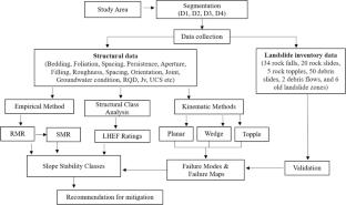
This study assesses the slope stability of various road cut slopes along National Highway (NH-44), which runs from Jawahar Tunnel Banihal to Ramban in the Kashmir Himalaya, India. Frequent landslides along NH-44 disrupt infrastructure, transportation, and the region’s development and economy. Ongoing road widening, tunneling activities, and heavy rainfall during the monsoon season lead to regular slope failures and blockages of NH-44. A comprehensive field survey was conducted to collect lithological and structural data for rock mass characterization, kinematic analysis, and slope stability evaluation. A total of 27 road cut slopes were analyzed for Rock Mass Rating (RMR) and Slope Mass Rating (SMR), while 48 sites were assessed for kinematic analysis. The area was divided into four domains (D-1, D-2, D-3, and D-4) based on major structural discontinuities for detailed study and analysis. The RMR values ranged from 8 to 82 (Very Poor to Very Good), while SMR values ranged from 7 to 82 (Very Bad to Very Good). Kinematic analysis identified that most failures are due to planar and wedge failures, with some toppling failures. The slopes, ranging from moderately stable to unstable, are prone to instability and collapse, especially due to changes in slope morphometry and frequent rainfall. The region lies within a tectonically active zone, making the slopes inherently unstable. This study’s integrated approach provides valuable insights into hazard mitigation, highlighting critical failure-prone areas and supporting better planning for infrastructure and sustainable development in the Himalayan region.
期刊介绍:
Applied Geomatics (AGMJ) is the official journal of SIFET the Italian Society of Photogrammetry and Topography and covers all aspects and information on scientific and technical advances in the geomatics sciences. The Journal publishes innovative contributions in geomatics applications ranging from the integration of instruments, methodologies and technologies and their use in the environmental sciences, engineering and other natural sciences.
The areas of interest include many research fields such as: remote sensing, close range and videometric photogrammetry, image analysis, digital mapping, land and geographic information systems, geographic information science, integrated geodesy, spatial data analysis, heritage recording; network adjustment and numerical processes. Furthermore, Applied Geomatics is open to articles from all areas of deformation measurements and analysis, structural engineering, mechanical engineering and all trends in earth and planetary survey science and space technology. The Journal also contains notices of conferences and international workshops, industry news, and information on new products. It provides a useful forum for professional and academic scientists involved in geomatics science and technology.
Information on Open Research Funding and Support may be found here: https://www.springernature.com/gp/open-research/institutional-agreements


 求助内容:
求助内容: 应助结果提醒方式:


