{"title":"Mobile GIS application for retaining wall data collection and risk management","authors":"Ameur Gharbi","doi":"10.1007/s12518-025-00645-3","DOIUrl":null,"url":null,"abstract":"<div><p>This paper describes the development and implementation of a mobile Geographic Information System (GIS) to improve the traditional method of retaining wall data collection and risk management in Algeria. This mobile GIS application is designed to help assess the condition of retaining walls and identify high-risk retaining walls. A risk assessment method based on retaining wall condition class and inventory data was developed to calculate a composite risk score for each retaining wall. Therefore, this system assists the quick creation of retaining wall condition maps by collecting information about the various defects of the retaining wall (influence zone defects, equipment defects, drainage defects, structure defects) using open-source GIS technologies such as QGIS, IntraMaps Roam, Spatialite, PostgreSQL, PostGIS, etc. In addition, this mobile GIS can be used in online and offline mode during field work in order to work in all network access conditions. To show the contribution of this system in the retaining wall data collection and risk management, an evaluation of the state of a sample of four retaining walls distributed over the Djelfa town (Algeria) was performed by the mobile GIS. A retaining wall risk score mapping was also performed. The evaluation showed that mobile GIS allows reliable data to be collected and recorded more uniformly and efficiently. It allows real-time visualization on the desktop of the updates made in the field. Therefore, mobile GIS can improve the quality and speed of retaining wall data collection and increase the effectiveness of retaining wall risk management.</p></div>","PeriodicalId":46286,"journal":{"name":"Applied Geomatics","volume":"17 4","pages":"749 - 769"},"PeriodicalIF":2.3000,"publicationDate":"2025-07-16","publicationTypes":"Journal Article","fieldsOfStudy":null,"isOpenAccess":false,"openAccessPdf":"","citationCount":"0","resultStr":null,"platform":"Semanticscholar","paperid":null,"PeriodicalName":"Applied Geomatics","FirstCategoryId":"1085","ListUrlMain":"https://link.springer.com/article/10.1007/s12518-025-00645-3","RegionNum":0,"RegionCategory":null,"ArticlePicture":[],"TitleCN":null,"AbstractTextCN":null,"PMCID":null,"EPubDate":"","PubModel":"","JCR":"Q2","JCRName":"REMOTE SENSING","Score":null,"Total":0}
引用次数: 0
Abstract
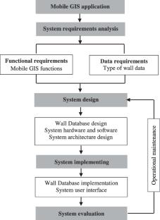
This paper describes the development and implementation of a mobile Geographic Information System (GIS) to improve the traditional method of retaining wall data collection and risk management in Algeria. This mobile GIS application is designed to help assess the condition of retaining walls and identify high-risk retaining walls. A risk assessment method based on retaining wall condition class and inventory data was developed to calculate a composite risk score for each retaining wall. Therefore, this system assists the quick creation of retaining wall condition maps by collecting information about the various defects of the retaining wall (influence zone defects, equipment defects, drainage defects, structure defects) using open-source GIS technologies such as QGIS, IntraMaps Roam, Spatialite, PostgreSQL, PostGIS, etc. In addition, this mobile GIS can be used in online and offline mode during field work in order to work in all network access conditions. To show the contribution of this system in the retaining wall data collection and risk management, an evaluation of the state of a sample of four retaining walls distributed over the Djelfa town (Algeria) was performed by the mobile GIS. A retaining wall risk score mapping was also performed. The evaluation showed that mobile GIS allows reliable data to be collected and recorded more uniformly and efficiently. It allows real-time visualization on the desktop of the updates made in the field. Therefore, mobile GIS can improve the quality and speed of retaining wall data collection and increase the effectiveness of retaining wall risk management.
期刊介绍:
Applied Geomatics (AGMJ) is the official journal of SIFET the Italian Society of Photogrammetry and Topography and covers all aspects and information on scientific and technical advances in the geomatics sciences. The Journal publishes innovative contributions in geomatics applications ranging from the integration of instruments, methodologies and technologies and their use in the environmental sciences, engineering and other natural sciences.
The areas of interest include many research fields such as: remote sensing, close range and videometric photogrammetry, image analysis, digital mapping, land and geographic information systems, geographic information science, integrated geodesy, spatial data analysis, heritage recording; network adjustment and numerical processes. Furthermore, Applied Geomatics is open to articles from all areas of deformation measurements and analysis, structural engineering, mechanical engineering and all trends in earth and planetary survey science and space technology. The Journal also contains notices of conferences and international workshops, industry news, and information on new products. It provides a useful forum for professional and academic scientists involved in geomatics science and technology.
Information on Open Research Funding and Support may be found here: https://www.springernature.com/gp/open-research/institutional-agreements


 求助内容:
求助内容: 应助结果提醒方式:


