Assessment of flood risk using integrated GIS and analytic hierarchy process in the Mekerra basin, Northwestern Algeria
IF 2.2
4区 地球科学
Q2 GEOSCIENCES, MULTIDISCIPLINARY
引用次数: 0
Abstract
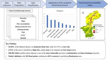
Flash floods are a significant risk in arid regions, especially in the Mekerra Basin of Northwestern Algeria, where rapid urbanization and climatic variability contribute to increasing flood vulnerability. This study integrates the Analytic Hierarchy Process (AHP) with Geographic Information Systems (GIS) to assess flood risk susceptibility in the basin. Eight key factors including, elevation, slope, drainage density, distance from rivers, flow accumulation, land use, topographic wetness index (TWI), and maximum daily rainfall were evaluated to calculate a Flood Susceptibility Index (FSI), categorizing the basin into flood risk levels. The findings show that 52.30 % of the basin is at moderate risk, while 42.37 % is at low risk. High-risk zones, representing 4.72 % of the area, are mainly located near the main wadi, where low-lying terrain, dense drainage networks, and urbanization contribute to increased flood vulnerability. The model achieved an 81 % accuracy when validated against historical flood data from 1986 to 2007, using a comparison of predicted flood-prone areas with observed flood occurrences. High-risk zones near the main wadi require immediate mitigation, such as reinforced infrastructure, while moderate-risk areas need targeted flood measures like improved drainage systems. Low-risk areas should focus on long-term strategies, including land-use planning and maintaining green spaces. The results highlight the combined impact of human activities and natural factors on flood risk, underscoring the importance of improving infrastructure and land-use planning, particularly in urban areas like Sidi Bel Abbes a major city in the basin. These findings underscore the need for targeted flood mitigation in urban areas and offer guidance for policymakers in improving infrastructure, land-use planning, and resilience against floods in the Mekerra Basin and similar regions.
基于GIS和层次分析法的阿尔及利亚西北部Mekerra流域洪水风险综合评价
在干旱地区,山洪暴发是一个重大风险,特别是在阿尔及利亚西北部的Mekerra盆地,那里的快速城市化和气候变化加剧了洪水的脆弱性。本研究将层次分析法(AHP)与地理信息系统(GIS)相结合,对流域洪水风险敏感性进行评估。通过对海拔、坡度、排水密度、与河流的距离、流量积累、土地利用、地形湿度指数(TWI)和最大日降雨量等8个关键因素进行评估,计算出洪水易发指数(FSI),并将流域划分为洪水风险等级。结果表明,流域中危区占52.30%,低危区占42.37%。高风险地区占总面积的4.72%,主要位于主河道附近,低洼地形、密集的排水网络和城市化都增加了洪水的脆弱性。当使用1986年至2007年的历史洪水数据进行验证时,该模型的准确率达到81%,该模型将预测的洪水易发地区与观测到的洪水发生情况进行了比较。主河道附近的高风险地区需要立即采取缓解措施,如加强基础设施,而中等风险地区需要采取有针对性的防洪措施,如改善排水系统。低风险地区应注重长期战略,包括土地利用规划和维护绿地。研究结果强调了人类活动和自然因素对洪水风险的综合影响,强调了改善基础设施和土地利用规划的重要性,特别是在像西迪贝勒阿贝斯这样的城市地区。西迪贝勒阿贝斯是该流域的一个主要城市。这些发现强调了在城市地区有针对性地减轻洪水的必要性,并为决策者在改善基础设施、土地利用规划和Mekerra盆地及类似地区的抗洪能力方面提供了指导。
本文章由计算机程序翻译,如有差异,请以英文原文为准。
求助全文
约1分钟内获得全文
求助全文
来源期刊

Journal of African Earth Sciences
地学-地球科学综合
CiteScore
4.70
自引率
4.30%
发文量
240
审稿时长
12 months
期刊介绍:
The Journal of African Earth Sciences sees itself as the prime geological journal for all aspects of the Earth Sciences about the African plate. Papers dealing with peripheral areas are welcome if they demonstrate a tight link with Africa.
The Journal publishes high quality, peer-reviewed scientific papers. It is devoted primarily to research papers but short communications relating to new developments of broad interest, reviews and book reviews will also be considered. Papers must have international appeal and should present work of more regional than local significance and dealing with well identified and justified scientific questions. Specialised technical papers, analytical or exploration reports must be avoided. Papers on applied geology should preferably be linked to such core disciplines and must be addressed to a more general geoscientific audience.
 求助内容:
求助内容: 应助结果提醒方式:


