Assessing the interconnectivity across complex dimensions of monitoring pelagic species of Sargassum and the role of citizen science
IF 4.5
1区 生物学
Q1 MARINE & FRESHWATER BIOLOGY
引用次数: 0
Abstract
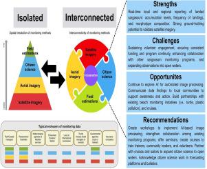
The mass accumulation of pelagic species of the genus Sargassum (referred to as sargassum) on coastlines is a pressing socio-environmental issue that spans the tropical Atlantic region. Since the unprecedented increase in biomass in 2011, innovative monitoring approaches have emerged to track sargassum across varying spatial and temporal scales, including satellite imagery, aerial imagery, citizen science, and traditional in situ evaluations of biomass. This study systematically reviewed peer-reviewed literature (2011–2024), gray literature, and open science sources to assess the methodologies used to monitor sargassum. Conversations with select experts involved in established monitoring programs, often tailored to end users such as government agencies or local communities, provided additional insight into the multidimensional nature of monitoring strategies. We found that while satellite imagery is commonly paired with in situ biomass evaluations in the literature, citizen science is emerging as a scalable, accessible tool to fill spatial and temporal gaps, despite limited representation in scientific publications. Aerial imagery is frequently mentioned as a promising supplement to both satellite and citizen science efforts, but its practical use remains limited. Field-based estimations remain the most direct method to quantify biomass but are constrained by spatial scale, funding, personnel, and feasibility for long-term monitoring. This review highlights the need for improved collaboration and data sharing across programs and scales, and creating platforms to return information to users. Strengthening connections among all involved in the design, participation, and use of community-based monitoring products, including a stronger relationship and clear benefits, will be essential to provide continuity and improve management strategies for this evolving environmental phenomenon.
评估马尾藻远洋物种监测复杂维度的互联性和公民科学的作用
马尾藻属(简称马尾藻)的远洋物种在海岸线上的大量积累是一个紧迫的社会环境问题,横跨热带大西洋地区。自2011年生物量空前增加以来,出现了创新的监测方法,以在不同的空间和时间尺度上跟踪马尾藻,包括卫星图像、航空图像、公民科学和传统的原位生物量评估。本研究系统地回顾了同行评议文献(2011-2024)、灰色文献和开放科学资源,以评估用于监测马尾藻的方法。通过与参与既定监测方案(通常针对政府机构或当地社区等最终用户量身定制)的选定专家的对话,我们进一步了解了监测战略的多维性。我们发现,虽然卫星图像通常与文献中的原位生物量评估相匹配,但公民科学正在成为一种可扩展的、可访问的工具,以填补空间和时间空白,尽管在科学出版物中的代表性有限。航空图像经常被认为是卫星和公民科学努力的一个有希望的补充,但它的实际应用仍然有限。实地估算仍然是量化生物量最直接的方法,但受到空间规模、资金、人员和长期监测可行性的限制。这篇综述强调了需要改进跨项目和规模的协作和数据共享,并创建向用户返回信息的平台。加强所有参与设计、参与和使用基于社区的监测产品的人之间的联系,包括建立更牢固的关系和明确的利益,对于为这一不断变化的环境现象提供连续性和改进管理战略至关重要。
本文章由计算机程序翻译,如有差异,请以英文原文为准。
求助全文
约1分钟内获得全文
求助全文
来源期刊
Harmful Algae
生物-海洋与淡水生物学
CiteScore
12.50
自引率
15.20%
发文量
122
审稿时长
7.5 months
期刊介绍:
This journal provides a forum to promote knowledge of harmful microalgae and macroalgae, including cyanobacteria, as well as monitoring, management and control of these organisms.
 求助内容:
求助内容: 应助结果提醒方式:


