{"title":"Optimizing ambulance location based on road accident data in Rwanda using machine learning algorithms.","authors":"Gatembo Bahati, Emmanuel Masabo","doi":"10.1186/s12942-025-00400-2","DOIUrl":null,"url":null,"abstract":"<p><strong>Background: </strong>The optimal placement of ambulances is critical for ensuring timely emergency medical responses, especially in regions with high accident frequencies. In Rwanda, where road accidents are a leading cause of injury and death, the strategic positioning of ambulances can significantly reduce response times and improve survival rates. The national records of Rwanda reveal a rising trend in the number of road accidents and deaths. In 2020, there were 4203 road traffic crashes throughout Rwanda with 687 deaths, data from 2021 demonstrated 8639 road traffic crashes with 655 deaths. Then in 2022 national statistics indicated 10,334 crushes with 729 deaths. The study used emergency response and road accident data collected by Rwanda Biomedical Centre in two fiscal years 2021-2022 and 2022-2023 consolidated with the administrative boundary of Rwandan sectors (shapefiles).</p><p><strong>Methods: </strong>The main objective was to optimize ambulance locations based on road accident data using machine learning algorithms. The methodology of this study used the random forest model to predict emergency response time and k-means clustering combined with linear programming to identify optimal hotspots for ambulance locations in Rwanda.</p><p><strong>Results: </strong>Random forest yields an accuracy of 94.3%, and positively classified emergency response time as 926 fast and 908 slow. K-means clustering combined with an optimization technique has grouped accident locations into two clusters and identified 58 optimal hotspots (stations) for ambulance locations in different regions of Rwanda with an average distance of 1092.773 m of ambulance station to the nearest accident location.</p><p><strong>Conclusion: </strong>Machine learning may identify hidden information that standard statistical approaches cannot, the developed model for random forest and k-means clustering combined with linear programming reveals a strong performance for optimizing ambulance location using road accident data.</p>","PeriodicalId":48739,"journal":{"name":"International Journal of Health Geographics","volume":"24 1","pages":"23"},"PeriodicalIF":3.0000,"publicationDate":"2025-08-27","publicationTypes":"Journal Article","fieldsOfStudy":null,"isOpenAccess":false,"openAccessPdf":"https://www.ncbi.nlm.nih.gov/pmc/articles/PMC12392543/pdf/","citationCount":"0","resultStr":null,"platform":"Semanticscholar","paperid":null,"PeriodicalName":"International Journal of Health Geographics","FirstCategoryId":"3","ListUrlMain":"https://doi.org/10.1186/s12942-025-00400-2","RegionNum":2,"RegionCategory":"医学","ArticlePicture":[],"TitleCN":null,"AbstractTextCN":null,"PMCID":null,"EPubDate":"","PubModel":"","JCR":"Q2","JCRName":"PUBLIC, ENVIRONMENTAL & OCCUPATIONAL HEALTH","Score":null,"Total":0}
引用次数: 0
Abstract
Background: The optimal placement of ambulances is critical for ensuring timely emergency medical responses, especially in regions with high accident frequencies. In Rwanda, where road accidents are a leading cause of injury and death, the strategic positioning of ambulances can significantly reduce response times and improve survival rates. The national records of Rwanda reveal a rising trend in the number of road accidents and deaths. In 2020, there were 4203 road traffic crashes throughout Rwanda with 687 deaths, data from 2021 demonstrated 8639 road traffic crashes with 655 deaths. Then in 2022 national statistics indicated 10,334 crushes with 729 deaths. The study used emergency response and road accident data collected by Rwanda Biomedical Centre in two fiscal years 2021-2022 and 2022-2023 consolidated with the administrative boundary of Rwandan sectors (shapefiles).
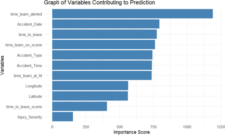
Methods: The main objective was to optimize ambulance locations based on road accident data using machine learning algorithms. The methodology of this study used the random forest model to predict emergency response time and k-means clustering combined with linear programming to identify optimal hotspots for ambulance locations in Rwanda.
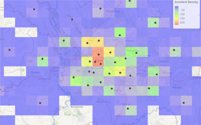
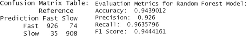
Results: Random forest yields an accuracy of 94.3%, and positively classified emergency response time as 926 fast and 908 slow. K-means clustering combined with an optimization technique has grouped accident locations into two clusters and identified 58 optimal hotspots (stations) for ambulance locations in different regions of Rwanda with an average distance of 1092.773 m of ambulance station to the nearest accident location.
Conclusion: Machine learning may identify hidden information that standard statistical approaches cannot, the developed model for random forest and k-means clustering combined with linear programming reveals a strong performance for optimizing ambulance location using road accident data.
期刊介绍:
A leader among the field, International Journal of Health Geographics is an interdisciplinary, open access journal publishing internationally significant studies of geospatial information systems and science applications in health and healthcare. With an exceptional author satisfaction rate and a quick time to first decision, the journal caters to readers across an array of healthcare disciplines globally.
International Journal of Health Geographics welcomes novel studies in the health and healthcare context spanning from spatial data infrastructure and Web geospatial interoperability research, to research into real-time Geographic Information Systems (GIS)-enabled surveillance services, remote sensing applications, spatial epidemiology, spatio-temporal statistics, internet GIS and cyberspace mapping, participatory GIS and citizen sensing, geospatial big data, healthy smart cities and regions, and geospatial Internet of Things and blockchain.
 求助内容:
求助内容: 应助结果提醒方式:


