Mapping forest fine-grained soil particle size distributions: a holistic GeoAI approach via graph neural networks, LiDAR, and Sentinel-2
IF 8.6
Q1 REMOTE SENSING
International journal of applied earth observation and geoinformation : ITC journal
Pub Date : 2025-09-01
DOI:10.1016/j.jag.2025.104807
引用次数: 0
Abstract
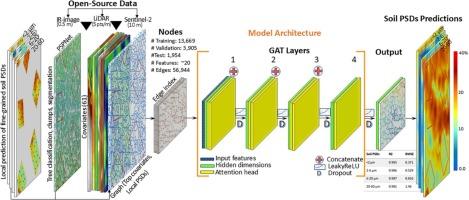
Fine-grained soils are crucial for assessing forest diversity and soil disturbances. Existing models for predicting particle size distributions (PSDs) often rely heavily on soil samples or lack necessary spatial dependencies, scalability and flexibility. This study introduces a holistic GeoAI model using graph neural networks (GNNs), LiDAR, and Sentinel-2 data to address these limitations. We collected 330 soil samples from 47 forest stands with a random-stratified method in southwestern Finland. The samples were pre-processed and analyzed for PSDs using a laser diffraction method, and classified into four groups: <2 µm, 2–6 µm, 6–20 µm, and 20–60 µm. To increase the number of annotations, we predicted soil PSDs at unmeasured locations using CoKriging within stands. The forests were segmented into small homogeneous polygons to construct the graph layer. We mapped 61 covariates using LiDAR and Sentinel-2 based on scorpan model, which were then summarized into the graph layer. Subsequently, we established the pipelines of five GNN models regarding the top covariates. The results indicate that geomorphometry and organisms covariates accounted for the majority of importance. The graph attention network (GAT) recorded high stability during training and remarkable prediction accuracy after testing with R2 values above 0.98 in predicting fine-grained soil PSDs across all four soil groups. Conversely, the relational graph convolutional networks (RGCN) also achieved R2 values above 0.97, but with lower stability and longer training times. However, the high accuracy of the predictive models is partly due to the large number of annotations derived from CoKriging, which may introduce uncertainties. Our GAT model demonstrated strong transferability when applied to an independent test stand using CoKriging-derived data (R2: 0.98–0.99) and showed robust performance when evaluated against real ground-truth samples (R2: 0.88–0.95). The observed prediction errors (RMSE: 0.68–2.82) reflect a combination of uncertainties originating from the CoKriging training data (RMSE: 0.34–2.46) and model-induced errors during training (RMSE: 0.37–1.46). Nevertheless, the consistently high R2 values indicate a strong agreement between predicted and measured soil PSDs. Future studies should focus on training the model with a larger number of ground-truth soil samples and evaluating its transferability across diverse boreal forest landscapes.
绘制森林细粒土壤粒度分布:通过图形神经网络、激光雷达和Sentinel-2的整体GeoAI方法
细粒土壤对于评估森林多样性和土壤扰动至关重要。现有的预测粒径分布(psd)的模型通常严重依赖于土壤样品或缺乏必要的空间依赖性、可扩展性和灵活性。本研究引入了一个使用图神经网络(gnn)、激光雷达和Sentinel-2数据的整体GeoAI模型来解决这些限制。采用随机分层方法,从芬兰西南部的47个林分中采集了330个土壤样本。采用激光衍射法对样品进行预处理和分析,并将样品分为4组:2µm、2 - 6µm、6-20µm和20-60µm。为了增加注释的数量,我们使用CoKriging方法预测了未测量位置的土壤psd。将森林分割成小的均匀多边形来构建图层。我们利用LiDAR和Sentinel-2基于scorpan模型绘制了61个协变量,然后将其汇总到图层中。随后,我们建立了关于顶部协变量的五个GNN模型的流水线。结果表明,地形和生物协变量占了大部分的重要性。图注意网络(GAT)在训练过程中具有较高的稳定性,在预测四种土壤组的细粒土壤psd时,经R2值大于0.98的检验,其预测精度显著。相反,关系图卷积网络(RGCN)的R2值也在0.97以上,但稳定性较差,训练时间较长。然而,预测模型的高准确性部分是由于大量来自CoKriging的注释,这可能会引入不确定性。我们的GAT模型在应用于使用cokriging衍生数据的独立试验台时显示出很强的可转移性(R2: 0.98-0.99),并且在对真实的地面真值样本进行评估时显示出稳健的性能(R2: 0.88-0.95)。观察到的预测误差(RMSE: 0.68-2.82)反映了来自CoKriging训练数据的不确定性(RMSE: 0.34-2.46)和训练期间模型引起的误差(RMSE: 0.37-1.46)的组合。然而,持续的高R2值表明土壤psd的预测值和实测值非常一致。未来的研究应侧重于用更多的真实土壤样本训练模型,并评估其在不同北方森林景观中的可转移性。
本文章由计算机程序翻译,如有差异,请以英文原文为准。
求助全文
约1分钟内获得全文
求助全文
来源期刊

International journal of applied earth observation and geoinformation : ITC journal
Global and Planetary Change, Management, Monitoring, Policy and Law, Earth-Surface Processes, Computers in Earth Sciences
CiteScore
12.00
自引率
0.00%
发文量
0
审稿时长
77 days
期刊介绍:
The International Journal of Applied Earth Observation and Geoinformation publishes original papers that utilize earth observation data for natural resource and environmental inventory and management. These data primarily originate from remote sensing platforms, including satellites and aircraft, supplemented by surface and subsurface measurements. Addressing natural resources such as forests, agricultural land, soils, and water, as well as environmental concerns like biodiversity, land degradation, and hazards, the journal explores conceptual and data-driven approaches. It covers geoinformation themes like capturing, databasing, visualization, interpretation, data quality, and spatial uncertainty.
 求助内容:
求助内容: 应助结果提醒方式:


