The pyxis project: A geospatial data system for emission estimation monitoring in the oil and gas industry
IF 9.6
Q1 COMPUTER SCIENCE, ARTIFICIAL INTELLIGENCE
引用次数: 0
Abstract
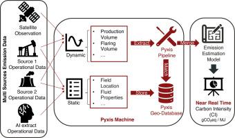
Consistent estimation and monitoring of greenhouse gas (GHG) emissions in the Oil and Gas (O&G) industry is challenging due to inaccessible, fragmented, and unstandardized datasets. Earlier efforts in estimating such emissions required extensive manual analysis to harmonize diverse data sources on O&G operations. Also, these analyses depend on flaring and methane leakage datasets, which should ideally be updated in near real-time, challenging to integrate effectively to process models. To tackle these challenges, this study proposes a Geographic Information System (GIS)-based data platform called Pyxis for integrating and managing data input associated with GHG emissions estimates in the O&G sector. The Pyxis architecture includes a scalable geodatabase for source management and an automated data pipeline for data management using spatial indexing. This greatly reduces the manual labor traditionally needed for data matching and merging. In addition, top-down remote sensing data can be seamlessly associated with bottom-up field operations data through Pyxis, which improves data recency and spatiotemporal coverage. Here, we apply Pyxis to the O&G fields of Brazil as a case study to show how it can help generating accurate estimates of Carbon Intensity (CI) with data management among disparate and inconsistent data sources. This work highlights the potential of scaling up Pyxis globally via integrating artificial intelligence models for data extraction and ultimately becoming a valuable tool for GHG emissions monitoring and policymaking in the O&G industry.
pyxis项目:一个用于石油和天然气工业排放估计监测的地理空间数据系统
由于难以获取、碎片化和非标准化的数据集,对石油和天然气行业温室气体(GHG)排放的一致估计和监测具有挑战性。早期估算此类排放的工作需要大量的人工分析,以协调不同的油气操作数据源。此外,这些分析依赖于燃烧和甲烷泄漏数据集,理想情况下,这些数据集应该是实时更新的,很难有效地整合到过程模型中。为了应对这些挑战,本研究提出了一个基于地理信息系统(GIS)的数据平台Pyxis,用于整合和管理与油气行业温室气体排放估算相关的数据输入。Pyxis体系结构包括用于源管理的可扩展地理数据库和用于使用空间索引进行数据管理的自动数据管道。这大大减少了传统上数据匹配和合并所需的手工劳动。此外,自上而下的遥感数据可以通过Pyxis与自下而上的野外作业数据无缝关联,提高了数据的近时性和时空覆盖度。在这里,我们将Pyxis应用于巴西的o&&g油田作为案例研究,以展示它如何通过在不同和不一致的数据源中进行数据管理来帮助生成碳强度(CI)的准确估计。通过整合人工智能模型进行数据提取,Pyxis有可能在全球范围内扩大规模,并最终成为油气行业温室气体排放监测和政策制定的宝贵工具。
本文章由计算机程序翻译,如有差异,请以英文原文为准。
求助全文
约1分钟内获得全文
求助全文
来源期刊

Energy and AI
Engineering-Engineering (miscellaneous)
CiteScore
16.50
自引率
0.00%
发文量
64
审稿时长
56 days
 求助内容:
求助内容: 应助结果提醒方式:


