Enhanced agricultural land use/land cover classification in the Nile Delta using Sentinel-1 and Sentinel-2 data and machine learning
IF 12.2
1区 地球科学
Q1 GEOGRAPHY, PHYSICAL
ISPRS Journal of Photogrammetry and Remote Sensing
Pub Date : 2025-08-29
DOI:10.1016/j.isprsjprs.2025.08.019
引用次数: 0
Abstract
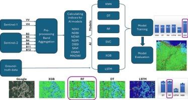
Accurate and timely Land Use and Land Cover (LULC) classification is crucial for effective agricultural planning and decision-making, particularly in regions like the Nile Delta, Egypt, where LULC is rapidly changing. This study addresses the challenge of classifying small, fragmented agricultural fields and road networks by leveraging the synergistic potential of Sentinel-1 and Sentinel-2 data, combined with Machine Learning (ML) and Deep Learning (DL) techniques. Unlike previous studies that often rely on Sentinel-2 or image-based DL, this research introduces a novel approach: a pixel-based ML classification using both Sentinel-1 and Sentinel-2 data. This strategy allowed to effectively capture the spectral and textural information crucial for distinguishing small features, which are often missed by traditional methods. Using distinct temporal datasets and validated ground truth annotations, we trained and tested several ML and DL models, including XGB, Support Vector Classifier, K-Nearest Neighbor, Decision Tree, Random Forest, and LSTM. XGB achieved the highest overall accuracy (94.4 %), whereas Random Forest produced the most accurate map with independent data (91.4 % Overall Accuracy). Integrating Sentinel-1 with Sentinel-2 data improved classification accuracy by 1–7 % compared to using Sentinel-2 alone. Notably, the pixel-based ML approach yielded reliable predictions for small road areas and agricultural fields, which are often challenging to map accurately. This research demonstrates the effectiveness of integrating multi-sensor data with advanced ML/DL for improved LULC classification, particularly for small feature mapping, thus providing critical information for enhanced agricultural planning and decision-making in the Nile Delta.
利用Sentinel-1和Sentinel-2数据和机器学习增强尼罗河三角洲农业用地/土地覆盖分类
准确和及时的土地利用和土地覆盖(LULC)分类对于有效的农业规划和决策至关重要,特别是在像埃及尼罗河三角洲这样的土地利用和土地覆盖迅速变化的地区。本研究通过利用Sentinel-1和Sentinel-2数据的协同潜力,结合机器学习(ML)和深度学习(DL)技术,解决了对小型、碎片化的农田和道路网络进行分类的挑战。与以往依赖于Sentinel-2或基于图像的深度学习的研究不同,本研究引入了一种新颖的方法:使用Sentinel-1和Sentinel-2数据进行基于像素的机器学习分类。这种策略可以有效地捕获光谱和纹理信息,这些信息对于区分小特征至关重要,而传统方法往往会遗漏这些信息。使用不同的时间数据集和经过验证的地面真相注释,我们训练和测试了几个ML和DL模型,包括XGB、支持向量分类器、k近邻、决策树、随机森林和LSTM。XGB实现了最高的总体精度(94.4%),而Random Forest用独立数据生成了最准确的地图(总体精度为91.4%)。与单独使用Sentinel-2相比,将Sentinel-1与Sentinel-2数据集成可将分类精度提高1 - 7%。值得注意的是,基于像素的机器学习方法对小道路区域和农田产生了可靠的预测,这通常是难以准确绘制的。该研究证明了将多传感器数据与先进的ML/DL集成在一起以改进LULC分类的有效性,特别是对于小特征映射,从而为加强尼罗河三角洲的农业规划和决策提供关键信息。
本文章由计算机程序翻译,如有差异,请以英文原文为准。
求助全文
约1分钟内获得全文
求助全文
来源期刊

ISPRS Journal of Photogrammetry and Remote Sensing
工程技术-成像科学与照相技术
CiteScore
21.00
自引率
6.30%
发文量
273
审稿时长
40 days
期刊介绍:
The ISPRS Journal of Photogrammetry and Remote Sensing (P&RS) serves as the official journal of the International Society for Photogrammetry and Remote Sensing (ISPRS). It acts as a platform for scientists and professionals worldwide who are involved in various disciplines that utilize photogrammetry, remote sensing, spatial information systems, computer vision, and related fields. The journal aims to facilitate communication and dissemination of advancements in these disciplines, while also acting as a comprehensive source of reference and archive.
P&RS endeavors to publish high-quality, peer-reviewed research papers that are preferably original and have not been published before. These papers can cover scientific/research, technological development, or application/practical aspects. Additionally, the journal welcomes papers that are based on presentations from ISPRS meetings, as long as they are considered significant contributions to the aforementioned fields.
In particular, P&RS encourages the submission of papers that are of broad scientific interest, showcase innovative applications (especially in emerging fields), have an interdisciplinary focus, discuss topics that have received limited attention in P&RS or related journals, or explore new directions in scientific or professional realms. It is preferred that theoretical papers include practical applications, while papers focusing on systems and applications should include a theoretical background.
 求助内容:
求助内容: 应助结果提醒方式:


