Deep learning-driven forest canopy height mapping in boreal regions through multi-source remote sensing fusion: Integrating Sentinel-1/2, PALSAR, and ICESat-2/LVIS data
IF 8.6
Q1 REMOTE SENSING
International journal of applied earth observation and geoinformation : ITC journal
Pub Date : 2025-08-26
DOI:10.1016/j.jag.2025.104766
引用次数: 0
Abstract
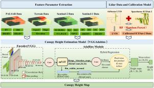
Forest canopy height is a key indicator for estimating forest carbon sinks and managing vegetation growth. Existing methods for fusing optical and Light Detection and Ranging (LiDAR) data still have limitations in canopy height estimation for boreal forests. In this study, we develop a forest canopy height estimation model (VGG-AdaBins) that leverages convolutional neural networks (CNNs) to extract deep features from multi-source remote sensing data. By introducing an adaptive tree height distribution estimation module, the model enables the coupling of multi-source remote sensing data for forest canopy height estimation. A joint validation dataset is constructed, including Sentinel-1/2, PALSAR images, airborne LVIS LiDAR, and spaceborne ICESat-2 photon-counting LiDAR data. This dataset is used to train the canopy height model. Finally, the performance of the canopy height prediction model is evaluated using 100 independent airborne datasets. The model’s prediction of tree height shows an MAE of 1.42 m and a RMSE of 2.25 m. The predicted 30 m canopy height map exhibits good consistency with the existing airborne data and demonstrated higher accuracy compared with current forest canopy height maps, with an accuracy improvement of at least 20%. The high prediction accuracy demonstrates that VGG-AdaBins, by integrating multi-source remote sensing data, can map continuous canopy height at the regional scale. This approach contributes to the advancement of large-scale canopy height mapping and forest carbon stock assessment in boreal forests.
基于多源遥感融合的深度学习驱动的北方地区森林冠层高度制图:整合Sentinel-1/2、PALSAR和ICESat-2/LVIS数据
森林冠层高度是估算森林碳汇和管理植被生长的关键指标。现有的融合光学和光探测与测距(LiDAR)数据的方法在估算北方森林冠层高度方面仍然存在局限性。在这项研究中,我们开发了一个森林冠层高度估计模型(VGG-AdaBins),该模型利用卷积神经网络(cnn)从多源遥感数据中提取深度特征。该模型通过引入自适应树高分布估算模块,实现了多源遥感数据耦合估算森林冠层高度。构建了一个联合验证数据集,包括Sentinel-1/2、PALSAR图像、机载LVIS激光雷达和星载ICESat-2光子计数激光雷达数据。该数据集用于训练冠层高度模型。最后,利用100个独立的航空数据集对冠层高度预测模型的性能进行了评估。模型对树高的预测MAE为1.42 m, RMSE为2.25 m。预测的30 m冠层高度图与现有航空数据具有较好的一致性,与现有森林冠层高度图相比精度更高,精度提高至少20%。较高的预测精度表明,VGG-AdaBins通过整合多源遥感数据,可以在区域尺度上绘制连续的冠层高度。该方法有助于推进大尺度冠层高度制图和森林碳储量评估。
本文章由计算机程序翻译,如有差异,请以英文原文为准。
求助全文
约1分钟内获得全文
求助全文
来源期刊

International journal of applied earth observation and geoinformation : ITC journal
Global and Planetary Change, Management, Monitoring, Policy and Law, Earth-Surface Processes, Computers in Earth Sciences
CiteScore
12.00
自引率
0.00%
发文量
0
审稿时长
77 days
期刊介绍:
The International Journal of Applied Earth Observation and Geoinformation publishes original papers that utilize earth observation data for natural resource and environmental inventory and management. These data primarily originate from remote sensing platforms, including satellites and aircraft, supplemented by surface and subsurface measurements. Addressing natural resources such as forests, agricultural land, soils, and water, as well as environmental concerns like biodiversity, land degradation, and hazards, the journal explores conceptual and data-driven approaches. It covers geoinformation themes like capturing, databasing, visualization, interpretation, data quality, and spatial uncertainty.
 求助内容:
求助内容: 应助结果提醒方式:


