Mapping barite vein-type deposits using Sentinel-2 data and fused spectral methods in a Paleozoic sedimentary cover (Eastern Anti-Atlas)
IF 2.2
4区 地球科学
Q2 GEOSCIENCES, MULTIDISCIPLINARY
引用次数: 0
Abstract
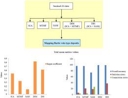
In Morocco, the southern part of the Saghro massif (Eastern Anti-Atlas) includes various economic deposits, including those of Barite (Ba). Previous studies revealed the high potential of these mineralizations, which are structurally controlled by a fault network. This study aims to improve the detection accuracy of barite by using fused remote sensing techniques with Sentinel-2 satellite imagery. This task was completed by comparing different methods, including independent component analysis (ICA), mixture-tuned matched filtering (MTMF), and spectral angle mapper (SAM) methods. These latter include novel fused classifications, namely directed ICA-MTMF (DIM) and directed ICA-SAM (DIS). The obtained results were checked and validated by a previous geological study, field observation, radar Sentinel-1 data, and the calculation of accuracy metrics. The analysis showed that the fused methods (especially the DIM classification) gave better results than the others. The combination of the high spatial resolution of Sentinel-2 data (10 m) and DIM fused classification allowed mapping the targeted veins accurately. Therefore, the adopted methodology can be applied to mineralogical and geological exploration and other remote sensing applications.
基于Sentinel-2数据和融合光谱方法的古生代沉积盖层重晶石脉型矿床填图(东部Anti-Atlas)
在摩洛哥,Saghro地块的南部(东反阿特拉斯)包括各种经济矿床,包括重晶石(Ba)矿床。以前的研究表明,这些矿化具有很高的潜力,它们在结构上受断裂网络控制。本研究旨在将遥感技术与Sentinel-2卫星影像融合,提高重晶石的探测精度。该任务通过比较独立分量分析(ICA)、混合调谐匹配滤波(MTMF)和光谱角映射(SAM)方法来完成。后者包括新的融合分类,即定向ICA-MTMF (DIM)和定向ICA-SAM (DIS)。通过之前的地质研究、现场观测、Sentinel-1雷达数据以及精度指标的计算,对所得结果进行了验证。分析表明,融合方法(尤其是DIM分类方法)的分类效果较好。Sentinel-2数据的高空间分辨率(10 m)与DIM融合分类相结合,可以准确地绘制目标矿脉。因此,所采用的方法可以应用于矿物学和地质勘探以及其他遥感应用。
本文章由计算机程序翻译,如有差异,请以英文原文为准。
求助全文
约1分钟内获得全文
求助全文
来源期刊

Journal of African Earth Sciences
地学-地球科学综合
CiteScore
4.70
自引率
4.30%
发文量
240
审稿时长
12 months
期刊介绍:
The Journal of African Earth Sciences sees itself as the prime geological journal for all aspects of the Earth Sciences about the African plate. Papers dealing with peripheral areas are welcome if they demonstrate a tight link with Africa.
The Journal publishes high quality, peer-reviewed scientific papers. It is devoted primarily to research papers but short communications relating to new developments of broad interest, reviews and book reviews will also be considered. Papers must have international appeal and should present work of more regional than local significance and dealing with well identified and justified scientific questions. Specialised technical papers, analytical or exploration reports must be avoided. Papers on applied geology should preferably be linked to such core disciplines and must be addressed to a more general geoscientific audience.
 求助内容:
求助内容: 应助结果提醒方式:


