{"title":"Connectivity of Nocturnal Cold-Air Flows for Urban Heat Island Mitigation: Introduction of the Cold-Air Trajectory Calculator KLATra","authors":"Paule Hainz, Meinolf Kossmann, Stephan Weber","doi":"10.1002/met.70080","DOIUrl":null,"url":null,"abstract":"<p>Ventilation of cities by local cold-air flows is an important measure in urban heat island mitigation and climate-resilient urban planning. We introduce a cold-air connectivity analysis to identify relevant cold-air formation areas as well as urban quarters ventilated by cold-air flows. The nocturnal cold-air flow trajectories are calculated from numerical model simulations using the single-layer cold-air drainage model KLAM_21 and the newly developed trajectory calculator KLATra. The German city of Freiburg im Breisgau is chosen to demonstrate the cold-air connectivity analysis based on trajectories calculated for two 3-hourly periods during an idealised night. Hydrological catchment boundaries and land use define eight rural cold-air formation areas as starting points for forward trajectories, whereas administrative urban district boundaries and land use data are used to define five built-up quarters potentially prone to overheating as starting points for cold-air backward trajectories. A rate of connectivity is calculated from the ratio of trajectories connecting cold-air formation areas with overheated urban quarters to the total number of trajectories. The analysis reveals the potential of cold-air formation areas to ventilate single or multiple urban quarters at connectivity rates up to 82%. The connectivity analysis therefore supports identification and assessment of the relevance of specific cold-air formation areas for urban heat island mitigation and may serve as a valuable planning tool and data basis for objective decision making.</p>","PeriodicalId":49825,"journal":{"name":"Meteorological Applications","volume":"32 4","pages":""},"PeriodicalIF":2.5000,"publicationDate":"2025-08-03","publicationTypes":"Journal Article","fieldsOfStudy":null,"isOpenAccess":false,"openAccessPdf":"https://onlinelibrary.wiley.com/doi/epdf/10.1002/met.70080","citationCount":"0","resultStr":null,"platform":"Semanticscholar","paperid":null,"PeriodicalName":"Meteorological Applications","FirstCategoryId":"89","ListUrlMain":"https://rmets.onlinelibrary.wiley.com/doi/10.1002/met.70080","RegionNum":4,"RegionCategory":"地球科学","ArticlePicture":[],"TitleCN":null,"AbstractTextCN":null,"PMCID":null,"EPubDate":"","PubModel":"","JCR":"Q3","JCRName":"METEOROLOGY & ATMOSPHERIC SCIENCES","Score":null,"Total":0}
引用次数: 0
Abstract
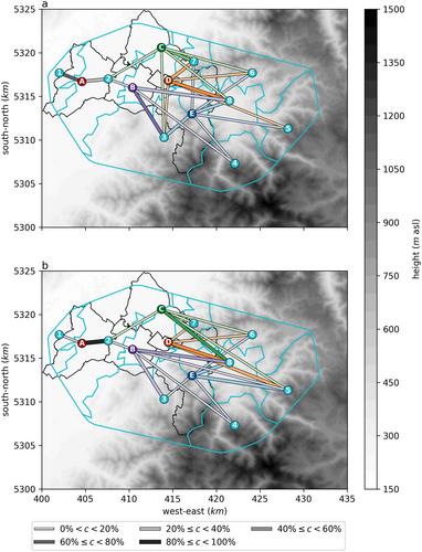
Ventilation of cities by local cold-air flows is an important measure in urban heat island mitigation and climate-resilient urban planning. We introduce a cold-air connectivity analysis to identify relevant cold-air formation areas as well as urban quarters ventilated by cold-air flows. The nocturnal cold-air flow trajectories are calculated from numerical model simulations using the single-layer cold-air drainage model KLAM_21 and the newly developed trajectory calculator KLATra. The German city of Freiburg im Breisgau is chosen to demonstrate the cold-air connectivity analysis based on trajectories calculated for two 3-hourly periods during an idealised night. Hydrological catchment boundaries and land use define eight rural cold-air formation areas as starting points for forward trajectories, whereas administrative urban district boundaries and land use data are used to define five built-up quarters potentially prone to overheating as starting points for cold-air backward trajectories. A rate of connectivity is calculated from the ratio of trajectories connecting cold-air formation areas with overheated urban quarters to the total number of trajectories. The analysis reveals the potential of cold-air formation areas to ventilate single or multiple urban quarters at connectivity rates up to 82%. The connectivity analysis therefore supports identification and assessment of the relevance of specific cold-air formation areas for urban heat island mitigation and may serve as a valuable planning tool and data basis for objective decision making.
期刊介绍:
The aim of Meteorological Applications is to serve the needs of applied meteorologists, forecasters and users of meteorological services by publishing papers on all aspects of meteorological science, including:
applications of meteorological, climatological, analytical and forecasting data, and their socio-economic benefits;
forecasting, warning and service delivery techniques and methods;
weather hazards, their analysis and prediction;
performance, verification and value of numerical models and forecasting services;
practical applications of ocean and climate models;
education and training.


 求助内容:
求助内容: 应助结果提醒方式:


