Characteristics of warm clouds under the Köppen climate classification system with contoured frequency by optical depth diagrams
IF 4.5
Q2 ENVIRONMENTAL SCIENCES
Remote Sensing Applications-Society and Environment
Pub Date : 2025-07-12
DOI:10.1016/j.rsase.2025.101657
引用次数: 0
Abstract
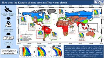
This study investigates the impact of atmospheric factors such as humidity, temperature, and aerosol properties on the growth and internal structure of warm clouds, focusing on variations in cloud optical depth (COD) and cloud droplet effective radius (CDR). Using satellite data from Aqua's Moderate Resolution Imaging Spectroradiometer and CloudSat's Cloud Profiling Radar (2006–2014), the study employs Contoured Frequency by Optical Depth Diagrams (CFODD) to analyze cloud evolution as CDR increases. The Köppen climate classification is applied to assess how atmospheric conditions influence warm cloud characteristics. The study finds that regions with similar climates exhibit comparable cloud behaviors. In tropical regions, cloud droplet mode dominates at CDR values between 6 and 15 μm, transitioning to rain as CDR exceeds 15 μm. In arid regions, limited moisture availability results in thinner warm clouds, a smaller CDR range, and fast cloud dissipation. Temperate and continental regions exhibit slower transitions from cloud droplet mode to drizzle and rain, with CDR exceeding 18 μm, while lower surface temperatures promote more drizzle formation. In polar regions, extremely low temperatures exacerbate these limitations by weakening turbulence and vertical motion, which further slow collision and coalescence processes, requiring a much larger CDR exceeding 21 μm for rain formation, with most precipitation occurring as drizzle.
基于光学深度图的频率等高线气候分类系统下的暖云特征
本文研究了湿度、温度和气溶胶特性等大气因子对暖云生长和内部结构的影响,重点研究了云光学深度(COD)和云滴有效半径(CDR)的变化。利用Aqua的中分辨率成像光谱仪和CloudSat的云剖面雷达(2006-2014)的卫星数据,该研究采用轮廓频率光学深度图(CFODD)来分析随着CDR的增加云的演变。应用Köppen气候分类来评估大气条件如何影响暖云特征。研究发现,气候相似的地区表现出相似的云行为。在热带地区,CDR值在6 ~ 15 μm之间以云滴模式为主,当CDR值超过15 μm时向降雨模式转变。在干旱地区,有限的水分可用性导致暖云变薄,CDR范围变小,云消散快。温带和大陆地区从云滴模式到毛毛雨和雨的转变较慢,CDR大于18 μm,而较低的地表温度促进毛毛雨的形成。在极地地区,极低的温度通过减弱湍流和垂直运动加剧了这些限制,这进一步减缓了碰撞和合并过程,需要超过21 μm的CDR才能形成降雨,大多数降水以毛毛雨的形式出现。
本文章由计算机程序翻译,如有差异,请以英文原文为准。
求助全文
约1分钟内获得全文
求助全文
来源期刊

CiteScore
8.00
自引率
8.50%
发文量
204
审稿时长
65 days
期刊介绍:
The journal ''Remote Sensing Applications: Society and Environment'' (RSASE) focuses on remote sensing studies that address specific topics with an emphasis on environmental and societal issues - regional / local studies with global significance. Subjects are encouraged to have an interdisciplinary approach and include, but are not limited by: " -Global and climate change studies addressing the impact of increasing concentrations of greenhouse gases, CO2 emission, carbon balance and carbon mitigation, energy system on social and environmental systems -Ecological and environmental issues including biodiversity, ecosystem dynamics, land degradation, atmospheric and water pollution, urban footprint, ecosystem management and natural hazards (e.g. earthquakes, typhoons, floods, landslides) -Natural resource studies including land-use in general, biomass estimation, forests, agricultural land, plantation, soils, coral reefs, wetland and water resources -Agriculture, food production systems and food security outcomes -Socio-economic issues including urban systems, urban growth, public health, epidemics, land-use transition and land use conflicts -Oceanography and coastal zone studies, including sea level rise projections, coastlines changes and the ocean-land interface -Regional challenges for remote sensing application techniques, monitoring and analysis, such as cloud screening and atmospheric correction for tropical regions -Interdisciplinary studies combining remote sensing, household survey data, field measurements and models to address environmental, societal and sustainability issues -Quantitative and qualitative analysis that documents the impact of using remote sensing studies in social, political, environmental or economic systems
 求助内容:
求助内容: 应助结果提醒方式:


