Continuous anomaly detection using remote sensing to monitor on-farm restoration in sub-Saharan Africa
IF 4.5
Q2 ENVIRONMENTAL SCIENCES
Remote Sensing Applications-Society and Environment
Pub Date : 2025-07-08
DOI:10.1016/j.rsase.2025.101644
引用次数: 0
Abstract
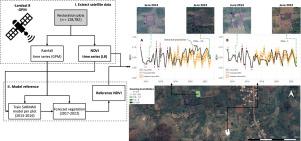
Land degradation poses a significant threat to ecosystem health and food security, particularly in the global South. Given the severity of land degradation globally, land restoration is urgently needed to recover degraded ecosystems through, for example, tree planting and (farmer-managed) natural regeneration (FMNR). In this study we monitor the impacts of farmer-managed land restoration using satellite time series data through a Continuous Anomaly Detection after Intervention (CADI) approach. We also propose ways that this approach can be used to generate insights to help design future land restoration interventions. Data was collected for 127,782 restoration plots in seven sub-Saharan countries through the use of the “Regreening App”, which was designed for citizen science data collection. For each plot, a reference NDVI was modelled based on multiple years prior to restoration interventions which was compared to the actual NDVI to quantify the restoration impact. A comparison between our CADI approach and the residual trend (RESTREND) method was done based on the visual interpretation of 645 validation points. The CADI analysis proved better able to detect greening compared to RESTREND (F-score: 0.84 vs 0.79) and it performed better in arid regions (F-score: 0.88) than in dry sub-humid ecosystems (F-score: 0.75). FMNR was predominantly preferred in arid regions where higher greening was observed, indicating FMNR as a powerful and cost-effective option for future land restoration initiatives. To stimulate further use by policy makers and practitioners, the CADI analysis has been made available as an online tool here.
利用遥感监测撒哈拉以南非洲农田恢复的连续异常检测
土地退化对生态系统健康和粮食安全构成重大威胁,特别是在全球南方国家。鉴于全球土地退化的严重程度,迫切需要通过植树和(农民管理的)自然再生(FMNR)等方式恢复退化的生态系统。在本研究中,我们通过干预后连续异常检测(CADI)方法,利用卫星时间序列数据监测农民管理的土地恢复的影响。我们还提出了一些方法,可以使用这种方法来产生见解,以帮助设计未来的土地恢复干预措施。通过使用为公民科学数据收集而设计的“绿化应用程序”,收集了7个撒哈拉以南国家的127,782个恢复地块的数据。对于每个地块,参考NDVI是基于恢复干预前多年建立的模型,并与实际NDVI进行比较,以量化恢复影响。基于645个验证点的视觉判读,将CADI方法与残差趋势(RESTREND)方法进行了比较。与RESTREND相比,CADI分析能够更好地检测绿化(F-score: 0.84 vs 0.79),并且在干旱地区(F-score: 0.88)比在干燥半湿润生态系统(F-score: 0.75)表现更好。在绿化率较高的干旱地区,FMNR是最受欢迎的,这表明FMNR是未来土地恢复举措的一个强大且具有成本效益的选择。为了鼓励决策者和从业人员进一步使用,CADI分析已作为在线工具在这里提供。
本文章由计算机程序翻译,如有差异,请以英文原文为准。
求助全文
约1分钟内获得全文
求助全文
来源期刊

CiteScore
8.00
自引率
8.50%
发文量
204
审稿时长
65 days
期刊介绍:
The journal ''Remote Sensing Applications: Society and Environment'' (RSASE) focuses on remote sensing studies that address specific topics with an emphasis on environmental and societal issues - regional / local studies with global significance. Subjects are encouraged to have an interdisciplinary approach and include, but are not limited by: " -Global and climate change studies addressing the impact of increasing concentrations of greenhouse gases, CO2 emission, carbon balance and carbon mitigation, energy system on social and environmental systems -Ecological and environmental issues including biodiversity, ecosystem dynamics, land degradation, atmospheric and water pollution, urban footprint, ecosystem management and natural hazards (e.g. earthquakes, typhoons, floods, landslides) -Natural resource studies including land-use in general, biomass estimation, forests, agricultural land, plantation, soils, coral reefs, wetland and water resources -Agriculture, food production systems and food security outcomes -Socio-economic issues including urban systems, urban growth, public health, epidemics, land-use transition and land use conflicts -Oceanography and coastal zone studies, including sea level rise projections, coastlines changes and the ocean-land interface -Regional challenges for remote sensing application techniques, monitoring and analysis, such as cloud screening and atmospheric correction for tropical regions -Interdisciplinary studies combining remote sensing, household survey data, field measurements and models to address environmental, societal and sustainability issues -Quantitative and qualitative analysis that documents the impact of using remote sensing studies in social, political, environmental or economic systems
 求助内容:
求助内容: 应助结果提醒方式:


