Utility of satellite imagery in estimating coastal marine water attributes
IF 2.2
3区 地球科学
Q2 OCEANOGRAPHY
引用次数: 0
Abstract
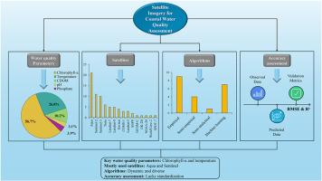
Coastal water resources are essential for sustaining biodiversity and community well-being, yet rapid population growth and climate change increasingly threaten their sustainability. Satellite remote sensing has emerged as a powerful tool for monitoring coastal water quality due to its extensive spatial coverage, cost effectiveness, and rapid data acquisition. The scientific community has seen considerable advances in recent years through these technologies. In view of these developments, this study presents a scoping review of 465 peer-reviewed journal articles published between 2019 and 2024, sourced from Scopus. The analysis identifies commonly used satellite platforms for assessing five critical water quality parameters chlorophyll-a (Chl-a), temperature, colored dissolved organic matter (CDOM), pH, and phosphate across predefined climatic zones and water types. We further examine prevalent algorithmic approaches and validation metrics. Findings indicate that most studies rely on data from Aqua, Sentinel, and Landsat satellites. Results also reveal that Chl-a and temperature are the most widely measured parameters, particularly in temperate and subtropical marine waters, whereas Arctic regions and freshwater systems remain understudied. Recent trends show a growing reliance on empirical and machine learning based algorithms, with root mean square error (RMSE) and coefficient of determination (R2) as the most common validation metrics. These results highlight the need for standardized validation protocols and expanded research efforts in underrepresented regions and parameters to enhance global water quality monitoring.
卫星图像在估算沿海海水属性中的应用
沿海水资源对维持生物多样性和社区福祉至关重要,但人口快速增长和气候变化日益威胁到其可持续性。卫星遥感由于其广泛的空间覆盖、成本效益和快速的数据获取,已成为监测沿海水质的有力工具。近年来,通过这些技术,科学界已经看到了相当大的进步。鉴于这些发展,本研究对2019年至2024年间发表的465篇同行评议期刊文章进行了范围审查,这些文章来自Scopus。该分析确定了常用的卫星平台,用于评估五个关键水质参数:叶绿素-a (Chl-a)、温度、彩色溶解有机质(CDOM)、pH值和磷酸盐,跨越预定的气候带和水类型。我们进一步研究了流行的算法方法和验证指标。研究结果表明,大多数研究依赖于Aqua、Sentinel和Landsat卫星的数据。结果还表明,Chl-a和温度是最广泛测量的参数,特别是在温带和亚热带海水中,而北极地区和淡水系统仍未得到充分研究。最近的趋势表明,越来越依赖于基于经验和机器学习的算法,均方根误差(RMSE)和确定系数(R2)是最常见的验证指标。这些结果强调需要标准化的验证方案,并在代表性不足的地区和参数中扩大研究工作,以加强全球水质监测。
本文章由计算机程序翻译,如有差异,请以英文原文为准。
求助全文
约1分钟内获得全文
求助全文
来源期刊
Continental Shelf Research
地学-海洋学
CiteScore
4.30
自引率
4.30%
发文量
136
审稿时长
6.1 months
期刊介绍:
Continental Shelf Research publishes articles dealing with the biological, chemical, geological and physical oceanography of the shallow marine environment, from coastal and estuarine waters out to the shelf break. The continental shelf is a critical environment within the land-ocean continuum, and many processes, functions and problems in the continental shelf are driven by terrestrial inputs transported through the rivers and estuaries to the coastal and continental shelf areas. Manuscripts that deal with these topics must make a clear link to the continental shelf. Examples of research areas include:
Physical sedimentology and geomorphology
Geochemistry of the coastal ocean (inorganic and organic)
Marine environment and anthropogenic effects
Interaction of physical dynamics with natural and manmade shoreline features
Benthic, phytoplankton and zooplankton ecology
Coastal water and sediment quality, and ecosystem health
Benthic-pelagic coupling (physical and biogeochemical)
Interactions between physical dynamics (waves, currents, mixing, etc.) and biogeochemical cycles
Estuarine, coastal and shelf sea modelling and process studies.
 求助内容:
求助内容: 应助结果提醒方式:


