Y. S. Bondarenko, D. A. Marshalov, S. R. Pavlov, A. L. Tolstoy
{"title":"Radar Mapping of the South Polar Region of the Moon at 4.2 cm Wavelength","authors":"Y. S. Bondarenko, D. A. Marshalov, S. R. Pavlov, A. L. Tolstoy","doi":"10.1134/S003809462460210X","DOIUrl":null,"url":null,"abstract":"<p>The paper presents new radar maps of the south polar region of the Moon at 4.2 cm wavelength with an average spatial resolution of 90 m. The maps are based on radar images obtained in 2023 using the 64-m TNA-1500 antenna of the Bear Lakes Satellite Communications Center of the Special Design Bureau of the Moscow Power Engineering Institute and the 13.2-m RT-13 radio telescopes at the Svetloe and Zelenchukskaya observatories of the Institute of Applied Astronomy of the Russian Academy of Sciences. Radar images are formed in a specific coordinate system relating the Doppler frequency shift with the propagation time delay of the echo components, which makes it difficult to tie them to selenographic coordinates. In this paper, an original method for converting echo Doppler frequency and time delay to selenographic latitude and longitude is proposed, using bilinear interpolation by ephemeris nodal values, taking into account long integration times. The accuracy of the reference of the maps constructed in this way was assessed and compared with the LROC WAC global optical map of the Moon and mosaics of permanently shadowed regions from LROC NAC. It is shown that radar maps at 4.2 cm wavelength contain features of the lunar surface that are hidden in optical images and are located in the regolith at depths of up to 1 m or in permanently shadowed regions of the south polar region of the Moon. The maps of the lunar echoes specular and diffuse polarization components, as well as a map of the distribution of circular polarization ratios, are available on the Internet at http://luna.iaaras.ru/ and can be useful for studying the geological history of the Moon, searching for ice deposits, and selecting safe landing sites when planning future lunar missions.</p>","PeriodicalId":778,"journal":{"name":"Solar System Research","volume":"59 5","pages":""},"PeriodicalIF":0.8000,"publicationDate":"2025-05-20","publicationTypes":"Journal Article","fieldsOfStudy":null,"isOpenAccess":false,"openAccessPdf":"","citationCount":"0","resultStr":null,"platform":"Semanticscholar","paperid":null,"PeriodicalName":"Solar System Research","FirstCategoryId":"101","ListUrlMain":"https://link.springer.com/article/10.1134/S003809462460210X","RegionNum":4,"RegionCategory":"物理与天体物理","ArticlePicture":[],"TitleCN":null,"AbstractTextCN":null,"PMCID":null,"EPubDate":"","PubModel":"","JCR":"Q4","JCRName":"ASTRONOMY & ASTROPHYSICS","Score":null,"Total":0}
引用次数: 0
Abstract
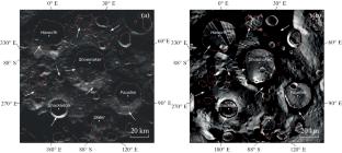
The paper presents new radar maps of the south polar region of the Moon at 4.2 cm wavelength with an average spatial resolution of 90 m. The maps are based on radar images obtained in 2023 using the 64-m TNA-1500 antenna of the Bear Lakes Satellite Communications Center of the Special Design Bureau of the Moscow Power Engineering Institute and the 13.2-m RT-13 radio telescopes at the Svetloe and Zelenchukskaya observatories of the Institute of Applied Astronomy of the Russian Academy of Sciences. Radar images are formed in a specific coordinate system relating the Doppler frequency shift with the propagation time delay of the echo components, which makes it difficult to tie them to selenographic coordinates. In this paper, an original method for converting echo Doppler frequency and time delay to selenographic latitude and longitude is proposed, using bilinear interpolation by ephemeris nodal values, taking into account long integration times. The accuracy of the reference of the maps constructed in this way was assessed and compared with the LROC WAC global optical map of the Moon and mosaics of permanently shadowed regions from LROC NAC. It is shown that radar maps at 4.2 cm wavelength contain features of the lunar surface that are hidden in optical images and are located in the regolith at depths of up to 1 m or in permanently shadowed regions of the south polar region of the Moon. The maps of the lunar echoes specular and diffuse polarization components, as well as a map of the distribution of circular polarization ratios, are available on the Internet at http://luna.iaaras.ru/ and can be useful for studying the geological history of the Moon, searching for ice deposits, and selecting safe landing sites when planning future lunar missions.
期刊介绍:
Solar System Research publishes articles concerning the bodies of the Solar System, i.e., planets and their satellites, asteroids, comets, meteoric substances, and cosmic dust. The articles consider physics, dynamics and composition of these bodies, and techniques of their exploration. The journal addresses the problems of comparative planetology, physics of the planetary atmospheres and interiors, cosmochemistry, as well as planetary plasma environment and heliosphere, specifically those related to solar-planetary interactions. Attention is paid to studies of exoplanets and complex problems of the origin and evolution of planetary systems including the solar system, based on the results of astronomical observations, laboratory studies of meteorites, relevant theoretical approaches and mathematical modeling. Alongside with the original results of experimental and theoretical studies, the journal publishes scientific reviews in the field of planetary exploration, and notes on observational results.

 求助内容:
求助内容: 应助结果提醒方式:


