Relationships of residential distance to greenhouse floriculture and organophosphate, pyrethroid, and neonicotinoid urinary metabolite concentration in Ecuadorian Adolescents.
IF 3 2区 医学Q2 PUBLIC, ENVIRONMENTAL & OCCUPATIONAL HEALTH
Briana N C Chronister, Georgia L Kayser, Franklin de la Cruz, Jose Suarez-Torres, Dolores Lopez-Paredes, Sheila Gahagan, Harvey Checkoway, Marta M Jankowska, Jose R Suarez-Lopez
{"title":"Relationships of residential distance to greenhouse floriculture and organophosphate, pyrethroid, and neonicotinoid urinary metabolite concentration in Ecuadorian Adolescents.","authors":"Briana N C Chronister, Georgia L Kayser, Franklin de la Cruz, Jose Suarez-Torres, Dolores Lopez-Paredes, Sheila Gahagan, Harvey Checkoway, Marta M Jankowska, Jose R Suarez-Lopez","doi":"10.1186/s12942-025-00395-w","DOIUrl":null,"url":null,"abstract":"<p><strong>Background: </strong>Adolescents living in agricultural areas are at higher risk of secondary pesticide exposure; however, there is limited evidence to confirm exposure by pesticide drift for greenhouse floriculture, like rose production.</p><p><strong>Methods: </strong>525 adolescents (12-17, 49% male) living in Pedro Moncayo, Ecuador were assessed in 2016. Urinary concentrations of creatinine and pesticide biomarkers (organophosphates, neonicotinoids, and pyrethroids) were measured using mass-spectrometry. Home distance to the nearest greenhouse and surface area of greenhouses within various buffer sizes around the home were calculated. Linear regression assessed whether home distance and surface area of greenhouses was associated with creatinine-adjusted metabolite concentration, adjusting for demographic, socioeconomic, and anthropometric variables. Geospatially weighted regression (GWR) was conducted, adjusting for similar covariates. Getis-ord Gi* identified hot and cold spots using a 1994 m distance band.</p><p><strong>Results: </strong>The associations between residential distance to greenhouses and urinary pesticide metabolites differed by metabolite type. The adjusted mean concentrations of OHIM (neonicotinoid) were greater (p-difference = 0.02) among participants living within 200 m (1.08 ug/g of creatinine) vs > 200 m (0.64 ug/g); however, the opposite was observed for 3,5,6-Trichloro-2-pyridinol (TCPy, organophosphate; 0-200 m: 3.63 ug/g vs > 200 m: 4.30 ug/g, p-diff = 0.05). In linear models, greater distances were negatively associated with para-nitrophenol (PNP, organophosphate; percent difference per 50% greater distance [95% CI]: - 2.5% [- 4.9%, - 0.1%]) and somewhat with 2-isopropyl-4-methyl-6-hydroxypyrimidine (IMPy, organophosphate; - 4.0% [- 8.3%, 0.4%]), among participants living within 200 m of greenhouses. Concurring with the adjusted means analyses, opposite (positive) associations were observed for TCPy (2.1% [95%CI 0.3%, 3.9%]). Organophosphate and pyrethroid hotspots were found in parishes with greater greenhouse density, whereas neonicotinoid hot spots were in parishes with the lowest greenhouse density.</p><p><strong>Conclusion: </strong>We observed negative associations between residential distance to greenhouses with OHIM, PNP and to some extent IMPy, suggesting that imidacloprid, parathion and diazinon are drifting from floricultural greenhouses and reaching children living within 200 m. Positive TCPy associations suggest greenhouses weren't the chlorpyrifos source during this study period, which implies that non-floricultural open-air agriculture (e.g. corn, potatoes, strawberries, grains) may be a source. Further research incorporating diverse geospatial constructs of pesticide sources, pesticide use reports (if available), participant location tracking, and repeated metabolite measurements is recommended.</p>","PeriodicalId":48739,"journal":{"name":"International Journal of Health Geographics","volume":"24 1","pages":"9"},"PeriodicalIF":3.0000,"publicationDate":"2025-04-18","publicationTypes":"Journal Article","fieldsOfStudy":null,"isOpenAccess":false,"openAccessPdf":"https://www.ncbi.nlm.nih.gov/pmc/articles/PMC12008992/pdf/","citationCount":"0","resultStr":null,"platform":"Semanticscholar","paperid":null,"PeriodicalName":"International Journal of Health Geographics","FirstCategoryId":"3","ListUrlMain":"https://doi.org/10.1186/s12942-025-00395-w","RegionNum":2,"RegionCategory":"医学","ArticlePicture":[],"TitleCN":null,"AbstractTextCN":null,"PMCID":null,"EPubDate":"","PubModel":"","JCR":"Q2","JCRName":"PUBLIC, ENVIRONMENTAL & OCCUPATIONAL HEALTH","Score":null,"Total":0}
引用次数: 0
Abstract
Background: Adolescents living in agricultural areas are at higher risk of secondary pesticide exposure; however, there is limited evidence to confirm exposure by pesticide drift for greenhouse floriculture, like rose production.
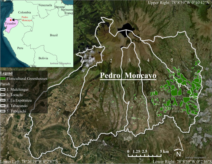
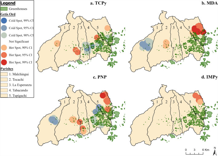
Methods: 525 adolescents (12-17, 49% male) living in Pedro Moncayo, Ecuador were assessed in 2016. Urinary concentrations of creatinine and pesticide biomarkers (organophosphates, neonicotinoids, and pyrethroids) were measured using mass-spectrometry. Home distance to the nearest greenhouse and surface area of greenhouses within various buffer sizes around the home were calculated. Linear regression assessed whether home distance and surface area of greenhouses was associated with creatinine-adjusted metabolite concentration, adjusting for demographic, socioeconomic, and anthropometric variables. Geospatially weighted regression (GWR) was conducted, adjusting for similar covariates. Getis-ord Gi* identified hot and cold spots using a 1994 m distance band.
Results: The associations between residential distance to greenhouses and urinary pesticide metabolites differed by metabolite type. The adjusted mean concentrations of OHIM (neonicotinoid) were greater (p-difference = 0.02) among participants living within 200 m (1.08 ug/g of creatinine) vs > 200 m (0.64 ug/g); however, the opposite was observed for 3,5,6-Trichloro-2-pyridinol (TCPy, organophosphate; 0-200 m: 3.63 ug/g vs > 200 m: 4.30 ug/g, p-diff = 0.05). In linear models, greater distances were negatively associated with para-nitrophenol (PNP, organophosphate; percent difference per 50% greater distance [95% CI]: - 2.5% [- 4.9%, - 0.1%]) and somewhat with 2-isopropyl-4-methyl-6-hydroxypyrimidine (IMPy, organophosphate; - 4.0% [- 8.3%, 0.4%]), among participants living within 200 m of greenhouses. Concurring with the adjusted means analyses, opposite (positive) associations were observed for TCPy (2.1% [95%CI 0.3%, 3.9%]). Organophosphate and pyrethroid hotspots were found in parishes with greater greenhouse density, whereas neonicotinoid hot spots were in parishes with the lowest greenhouse density.
Conclusion: We observed negative associations between residential distance to greenhouses with OHIM, PNP and to some extent IMPy, suggesting that imidacloprid, parathion and diazinon are drifting from floricultural greenhouses and reaching children living within 200 m. Positive TCPy associations suggest greenhouses weren't the chlorpyrifos source during this study period, which implies that non-floricultural open-air agriculture (e.g. corn, potatoes, strawberries, grains) may be a source. Further research incorporating diverse geospatial constructs of pesticide sources, pesticide use reports (if available), participant location tracking, and repeated metabolite measurements is recommended.
期刊介绍:
A leader among the field, International Journal of Health Geographics is an interdisciplinary, open access journal publishing internationally significant studies of geospatial information systems and science applications in health and healthcare. With an exceptional author satisfaction rate and a quick time to first decision, the journal caters to readers across an array of healthcare disciplines globally.
International Journal of Health Geographics welcomes novel studies in the health and healthcare context spanning from spatial data infrastructure and Web geospatial interoperability research, to research into real-time Geographic Information Systems (GIS)-enabled surveillance services, remote sensing applications, spatial epidemiology, spatio-temporal statistics, internet GIS and cyberspace mapping, participatory GIS and citizen sensing, geospatial big data, healthy smart cities and regions, and geospatial Internet of Things and blockchain.

 求助内容:
求助内容: 应助结果提醒方式:


