Unveiling the Frailty Spatial Patterns Among Chilean Older Persons by Exploring Sociodemographic and Urbanistic Influences Based on Geographic Information Systems: Cross-Sectional Study.
Yony Ormazábal, Diego Arauna, Juan Carlos Cantillana, Iván Palomo, Eduardo Fuentes, Carlos Mena
{"title":"Unveiling the Frailty Spatial Patterns Among Chilean Older Persons by Exploring Sociodemographic and Urbanistic Influences Based on Geographic Information Systems: Cross-Sectional Study.","authors":"Yony Ormazábal, Diego Arauna, Juan Carlos Cantillana, Iván Palomo, Eduardo Fuentes, Carlos Mena","doi":"10.2196/64254","DOIUrl":null,"url":null,"abstract":"<p><strong>Background: </strong>Frailty syndrome increases the vulnerability of older adults. The growing proportion of older adults highlights the need to better understand the factors contributing to the prevalence of frailty. Current evidence suggests that geomatic tools integrating geolocation can provide valuable information for implementing preventive measures by enhancing the urban physical environment.</p><p><strong>Objective: </strong>The aim of this study was to analyze the relationship between various elements of the urban physical environment and the level of frailty syndrome in older Chilean people.</p><p><strong>Methods: </strong>A cohort of 251 adults aged 65 years or older from Talca City, Chile, underwent comprehensive medical assessments and were geographically mapped within a Geographic Information Systems database. Frailty was determined using the Fried frailty criteria. The spatial analysis of the frailty was conducted in conjunction with layers depicting urban physical facilities within the city, including vegetables and fruit shops, senior centers or communities, pharmacies, emergency health centers, main squares and parks, family or community health centers, and sports facilities such as stadiums.</p><p><strong>Results: </strong>The studied cohort was composed of 187 women and 64 men, with no significant differences in age and BMI between genders. Frailty prevalence varied significantly across clusters, with Cluster 3 showing the highest prevalence (14/47, P=.01). Frail individuals resided significantly closer to emergency health centers (960 [SE 904] m vs 1352 [SE 936] m, P=.04), main squares/parks (1550 [SE 130] m vs. 2048 [SE 105] m, P=.03), and sports fields (3040 [SE 236] m vs 4457 [SE 322]m, P=.04) compared with nonfrail individuals. There were no significant differences in urban quality index across frailty groups, but frail individuals lived in areas with higher population density (0.013 [SE 0.001] vs 0.01 [SE 0.0007], P=.03).</p><p><strong>Conclusions: </strong>Frail individuals exhibit geospatial patterns suggesting intentional proximity to health facilities, sports venues, and urban facilities, revealing associations with adaptive responses to frailty and socioeconomic factors. This highlights the crucial intersection of urban environments and frailty, which is important for geriatric medicine and public health initiatives.</p>","PeriodicalId":36245,"journal":{"name":"JMIR Aging","volume":"8 ","pages":"e64254"},"PeriodicalIF":4.8000,"publicationDate":"2025-04-17","publicationTypes":"Journal Article","fieldsOfStudy":null,"isOpenAccess":false,"openAccessPdf":"https://www.ncbi.nlm.nih.gov/pmc/articles/PMC12021301/pdf/","citationCount":"0","resultStr":null,"platform":"Semanticscholar","paperid":null,"PeriodicalName":"JMIR Aging","FirstCategoryId":"1085","ListUrlMain":"https://doi.org/10.2196/64254","RegionNum":0,"RegionCategory":null,"ArticlePicture":[],"TitleCN":null,"AbstractTextCN":null,"PMCID":null,"EPubDate":"","PubModel":"","JCR":"Q1","JCRName":"GERIATRICS & GERONTOLOGY","Score":null,"Total":0}
引用次数: 0
Abstract
Background: Frailty syndrome increases the vulnerability of older adults. The growing proportion of older adults highlights the need to better understand the factors contributing to the prevalence of frailty. Current evidence suggests that geomatic tools integrating geolocation can provide valuable information for implementing preventive measures by enhancing the urban physical environment.
Objective: The aim of this study was to analyze the relationship between various elements of the urban physical environment and the level of frailty syndrome in older Chilean people.
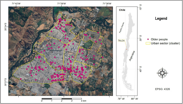
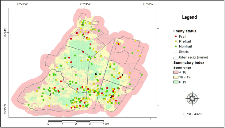
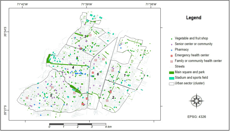
Methods: A cohort of 251 adults aged 65 years or older from Talca City, Chile, underwent comprehensive medical assessments and were geographically mapped within a Geographic Information Systems database. Frailty was determined using the Fried frailty criteria. The spatial analysis of the frailty was conducted in conjunction with layers depicting urban physical facilities within the city, including vegetables and fruit shops, senior centers or communities, pharmacies, emergency health centers, main squares and parks, family or community health centers, and sports facilities such as stadiums.
Results: The studied cohort was composed of 187 women and 64 men, with no significant differences in age and BMI between genders. Frailty prevalence varied significantly across clusters, with Cluster 3 showing the highest prevalence (14/47, P=.01). Frail individuals resided significantly closer to emergency health centers (960 [SE 904] m vs 1352 [SE 936] m, P=.04), main squares/parks (1550 [SE 130] m vs. 2048 [SE 105] m, P=.03), and sports fields (3040 [SE 236] m vs 4457 [SE 322]m, P=.04) compared with nonfrail individuals. There were no significant differences in urban quality index across frailty groups, but frail individuals lived in areas with higher population density (0.013 [SE 0.001] vs 0.01 [SE 0.0007], P=.03).
Conclusions: Frail individuals exhibit geospatial patterns suggesting intentional proximity to health facilities, sports venues, and urban facilities, revealing associations with adaptive responses to frailty and socioeconomic factors. This highlights the crucial intersection of urban environments and frailty, which is important for geriatric medicine and public health initiatives.

 求助内容:
求助内容: 应助结果提醒方式:


