Matthew J. Hardy, Christopher K. Williams, Brian S. Ladman, Maurice E. Pitesky, Cory T. Overton, Michael L. Casazza, Elliott L. Matchett, Diann J. Prosser, Jeffrey J. Buler
{"title":"Examining inter-regional and intra-seasonal differences in wintering waterfowl landscape associations among Pacific and Atlantic flyways","authors":"Matthew J. Hardy, Christopher K. Williams, Brian S. Ladman, Maurice E. Pitesky, Cory T. Overton, Michael L. Casazza, Elliott L. Matchett, Diann J. Prosser, Jeffrey J. Buler","doi":"10.1111/jav.03296","DOIUrl":null,"url":null,"abstract":"<p>The Central Valley of California (CVC) and Mid-Atlantic (MA) in the U.S. are both critical sites for nationwide food security, and many waterfowl species annually, especially during the winter, providing feeding and roosting locations for a variety of species. Mapping waterfowl distributions, using NEXRAD, may aid in the adaptive management of important waterfowl habitat and allow various government agencies to better understand the interface between wild and domestic birds and commercial agricultural practices. We used 9 years (2014–2023) of data from the US NEXRAD network to model winter waterfowl relative abundance in the CVC and MA as a function of weather, temporal period, environmental conditions, and landcover characteristics using boosted regression tree modelling. We were able to quantify the variability in effect size of 28 different covariates across space and time within two geographic regions which are critical to nationwide waterfowl management and host a high density of nationally important commercial agriculture. In general, weather, geographic (distance to features), and landcover condition (wetness index) predictors had the strongest relative effect on predicting wintering waterfowl relative abundance in both regions, while effects of land cover composition were more regionally and temporally specific. Increased daily mean temperature was a major predictor of increasing relative waterfowl abundance in both regions throughout the winter. Increasing precipitation had differing effects within regions, increasing relative waterfowl abundance in the MA, while decreasing in general within the CVC. Increasing relative waterfowl abundance in the CVC are strongly tied to the flooding of the landscape and rice availability, whereas waterfowl in the MA, where water is less limiting, are generally governed by waste grain availability and emergent wetland on the landscape. Waterfowl relative abundance in the MA was generally higher nearer to the Atlantic coast and lakes, while in the CVC they were higher nearer to lakes. Our findings promote a better understanding of spatial associations of waterfowl to landscape features and may aid in conservation and biosecurity management protocols.</p>","PeriodicalId":15278,"journal":{"name":"Journal of Avian Biology","volume":"2025 3","pages":""},"PeriodicalIF":1.8000,"publicationDate":"2024-12-18","publicationTypes":"Journal Article","fieldsOfStudy":null,"isOpenAccess":false,"openAccessPdf":"https://onlinelibrary.wiley.com/doi/epdf/10.1111/jav.03296","citationCount":"0","resultStr":null,"platform":"Semanticscholar","paperid":null,"PeriodicalName":"Journal of Avian Biology","FirstCategoryId":"99","ListUrlMain":"https://nsojournals.onlinelibrary.wiley.com/doi/10.1111/jav.03296","RegionNum":3,"RegionCategory":"生物学","ArticlePicture":[],"TitleCN":null,"AbstractTextCN":null,"PMCID":null,"EPubDate":"","PubModel":"","JCR":"Q1","JCRName":"ORNITHOLOGY","Score":null,"Total":0}
引用次数: 0
Abstract
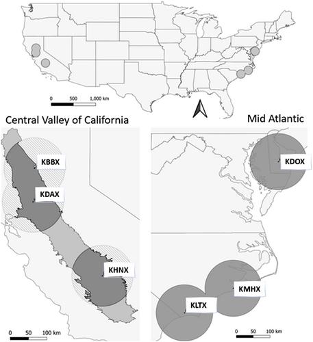
The Central Valley of California (CVC) and Mid-Atlantic (MA) in the U.S. are both critical sites for nationwide food security, and many waterfowl species annually, especially during the winter, providing feeding and roosting locations for a variety of species. Mapping waterfowl distributions, using NEXRAD, may aid in the adaptive management of important waterfowl habitat and allow various government agencies to better understand the interface between wild and domestic birds and commercial agricultural practices. We used 9 years (2014–2023) of data from the US NEXRAD network to model winter waterfowl relative abundance in the CVC and MA as a function of weather, temporal period, environmental conditions, and landcover characteristics using boosted regression tree modelling. We were able to quantify the variability in effect size of 28 different covariates across space and time within two geographic regions which are critical to nationwide waterfowl management and host a high density of nationally important commercial agriculture. In general, weather, geographic (distance to features), and landcover condition (wetness index) predictors had the strongest relative effect on predicting wintering waterfowl relative abundance in both regions, while effects of land cover composition were more regionally and temporally specific. Increased daily mean temperature was a major predictor of increasing relative waterfowl abundance in both regions throughout the winter. Increasing precipitation had differing effects within regions, increasing relative waterfowl abundance in the MA, while decreasing in general within the CVC. Increasing relative waterfowl abundance in the CVC are strongly tied to the flooding of the landscape and rice availability, whereas waterfowl in the MA, where water is less limiting, are generally governed by waste grain availability and emergent wetland on the landscape. Waterfowl relative abundance in the MA was generally higher nearer to the Atlantic coast and lakes, while in the CVC they were higher nearer to lakes. Our findings promote a better understanding of spatial associations of waterfowl to landscape features and may aid in conservation and biosecurity management protocols.
期刊介绍:
Journal of Avian Biology publishes empirical and theoretical research in all areas of ornithology, with an emphasis on behavioural ecology, evolution and conservation.


 求助内容:
求助内容: 应助结果提醒方式:


