Relationships between fixed-site ambient measurements of nitrogen dioxide, ozone, and particulate matter and personal exposures in Grand Paris, France: the MobiliSense study.
IF 3 2区 医学Q2 PUBLIC, ENVIRONMENTAL & OCCUPATIONAL HEALTH
{"title":"Relationships between fixed-site ambient measurements of nitrogen dioxide, ozone, and particulate matter and personal exposures in Grand Paris, France: the MobiliSense study.","authors":"Sanjeev Bista, Giovanna Fancello, Karine Zeitouni, Isabella Annesi-Maesano, Basile Chaix","doi":"10.1186/s12942-025-00393-y","DOIUrl":null,"url":null,"abstract":"<p><strong>Background: </strong>Past epidemiological studies, using fixed-site outdoor air pollution measurements as a proxy for participants' exposure, might have suffered from exposure misclassification.</p><p><strong>Methods: </strong>In the MobiliSense study, personal exposures to ozone (O<sub>3</sub>), nitrogen dioxide (NO<sub>2</sub>), and particles with aerodynamic diameters below 2.5 μm (PM<sub>2.5</sub>) were monitored with a personal air quality monitor. All the spatial location points collected with a personal GPS receiver and mobility survey were used to retrieve background hourly concentrations of air pollutants from the nearest Airparif monitoring station. We modeled 851,343 min-level observations from 246 participants.</p><p><strong>Results: </strong>Visited places including the residence contributed the majority of the minute-level observations, 93.0%, followed by active transport (3.4%), and the rest were from on-road and rail transport, 2.4% and 1.1%, respectively. Comparison of personal exposures and station-measured concentrations for each individual indicated low Spearman correlations for NO<sub>2</sub> (median across participants: 0.23), O<sub>3</sub> (median: 0.21), and PM<sub>2.5</sub> (median: 0.27), with varying levels of correlation by microenvironments (ranging from 0.06 to 0.35 according to the microenvironment). Results from mixed-effect models indicated that personal exposure was very weakly explained by station-measured concentrations (R<sup>2</sup> < 0.07) for all air pollutants. The R<sup>2</sup> for only a few models was higher than 0.15, namely for O<sub>3</sub> in the active transport microenvironment (R<sup>2</sup>: 0.25) and for PM<sub>2.5</sub> in active transport (R<sup>2</sup>: 0.16) and in the separated rail transport microenvironment (R<sup>2</sup>: 0.20). Model fit slightly increased with decreasing distance between participants' location and the nearest monitoring station.</p><p><strong>Conclusions: </strong>Our results demonstrated a relatively low correlation between personal exposure and station-measured air pollutants, confirming that station-measured concentrations as proxies of personal exposures can lead to exposure misclassification. However, distance and the type of microenvironment are shown to affect the extent of misclassification.</p>","PeriodicalId":48739,"journal":{"name":"International Journal of Health Geographics","volume":"24 1","pages":"5"},"PeriodicalIF":3.0000,"publicationDate":"2025-03-27","publicationTypes":"Journal Article","fieldsOfStudy":null,"isOpenAccess":false,"openAccessPdf":"https://www.ncbi.nlm.nih.gov/pmc/articles/PMC11948884/pdf/","citationCount":"0","resultStr":null,"platform":"Semanticscholar","paperid":null,"PeriodicalName":"International Journal of Health Geographics","FirstCategoryId":"3","ListUrlMain":"https://doi.org/10.1186/s12942-025-00393-y","RegionNum":2,"RegionCategory":"医学","ArticlePicture":[],"TitleCN":null,"AbstractTextCN":null,"PMCID":null,"EPubDate":"","PubModel":"","JCR":"Q2","JCRName":"PUBLIC, ENVIRONMENTAL & OCCUPATIONAL HEALTH","Score":null,"Total":0}
引用次数: 0
Abstract
Background: Past epidemiological studies, using fixed-site outdoor air pollution measurements as a proxy for participants' exposure, might have suffered from exposure misclassification.
Methods: In the MobiliSense study, personal exposures to ozone (O3), nitrogen dioxide (NO2), and particles with aerodynamic diameters below 2.5 μm (PM2.5) were monitored with a personal air quality monitor. All the spatial location points collected with a personal GPS receiver and mobility survey were used to retrieve background hourly concentrations of air pollutants from the nearest Airparif monitoring station. We modeled 851,343 min-level observations from 246 participants.
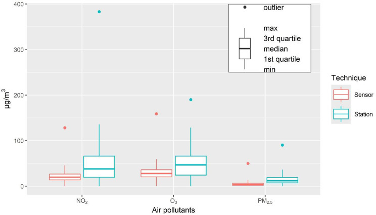
Results: Visited places including the residence contributed the majority of the minute-level observations, 93.0%, followed by active transport (3.4%), and the rest were from on-road and rail transport, 2.4% and 1.1%, respectively. Comparison of personal exposures and station-measured concentrations for each individual indicated low Spearman correlations for NO2 (median across participants: 0.23), O3 (median: 0.21), and PM2.5 (median: 0.27), with varying levels of correlation by microenvironments (ranging from 0.06 to 0.35 according to the microenvironment). Results from mixed-effect models indicated that personal exposure was very weakly explained by station-measured concentrations (R2 < 0.07) for all air pollutants. The R2 for only a few models was higher than 0.15, namely for O3 in the active transport microenvironment (R2: 0.25) and for PM2.5 in active transport (R2: 0.16) and in the separated rail transport microenvironment (R2: 0.20). Model fit slightly increased with decreasing distance between participants' location and the nearest monitoring station.
Conclusions: Our results demonstrated a relatively low correlation between personal exposure and station-measured air pollutants, confirming that station-measured concentrations as proxies of personal exposures can lead to exposure misclassification. However, distance and the type of microenvironment are shown to affect the extent of misclassification.
期刊介绍:
A leader among the field, International Journal of Health Geographics is an interdisciplinary, open access journal publishing internationally significant studies of geospatial information systems and science applications in health and healthcare. With an exceptional author satisfaction rate and a quick time to first decision, the journal caters to readers across an array of healthcare disciplines globally.
International Journal of Health Geographics welcomes novel studies in the health and healthcare context spanning from spatial data infrastructure and Web geospatial interoperability research, to research into real-time Geographic Information Systems (GIS)-enabled surveillance services, remote sensing applications, spatial epidemiology, spatio-temporal statistics, internet GIS and cyberspace mapping, participatory GIS and citizen sensing, geospatial big data, healthy smart cities and regions, and geospatial Internet of Things and blockchain.
 求助内容:
求助内容: 应助结果提醒方式:


