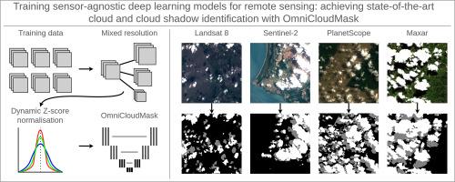
Training sensor-agnostic deep learning models for remote sensing: Achieving state-of-the-art cloud and cloud shadow identification with OmniCloudMask
IF 11.1
1区 地球科学
Q1 ENVIRONMENTAL SCIENCES
引用次数: 0
Abstract
Deep learning models are widely used to extract features and insights from remotely sensed imagery. However, these models typically perform optimally when applied to the same sensor, resolution and imagery processing level as used during their training, and are rarely used or evaluated on out-of-domain data. This limitation results in duplication of efforts in collecting similar training datasets from different satellites to train sensor-specific models. Here, we introduce a range of techniques to train deep learning models that generalise across various sensors, resolutions, and processing levels. We applied this approach to train OmniCloudMask (OCM), a sensor-agnostic deep learning model that segments clouds and cloud shadow. OCM demonstrates robust state-of-the-art performance across various satellite platforms when classifying clear, cloud, and shadow classes, with balanced overall accuracy values across: Landsat (91.5 % clear, 91.5 % cloud, and 75.2 % shadow); Sentinel-2 (92.2 % clear, 91.2 % cloud, and 80.5 % shadow); and PlanetScope (96.9 % clear, 98.8 % cloud, and 97.4 % shadow). OCM achieves this accuracy while only being trained on a single Sentinel-2 dataset, employing spectral normalisation and mixed resolution training to address the spectral and spatial differences between satellite platforms. This approach allows the model to effectively handle imagery from different sensors within the 10 m to 50 m resolution range, as well as higher resolution imagery that has been resampled to 10 m. The OCM library is available as an open source Python package on PyPI.

训练遥感传感器不可知的深度学习模型:用OmniCloudMask实现最先进的云和云影识别
深度学习模型被广泛用于从遥感图像中提取特征和见解。然而,当应用于与训练期间使用的相同的传感器,分辨率和图像处理水平时,这些模型通常表现最佳,并且很少在域外数据上使用或评估。这一限制导致从不同卫星收集类似训练数据集以训练特定传感器模型的工作重复。在这里,我们介绍了一系列技术来训练深度学习模型,这些模型可以在各种传感器、分辨率和处理水平上进行泛化。我们应用这种方法来训练OmniCloudMask (OCM),这是一种与传感器无关的深度学习模型,可以分割云和云阴影。在对晴空、云和阴影进行分类时,OCM在各种卫星平台上展示了强大的最先进性能,在陆地卫星(91.5%晴空、91.5%云和75.2%阴影)上具有平衡的总体精度值;哨兵-2(92.2%透明,91.2%云,80.5%阴影);和PlanetScope(96.9%是透明的,98.8%是云,97.4%是阴影)。OCM仅在单一Sentinel-2数据集上进行训练,采用光谱归一化和混合分辨率训练来解决卫星平台之间的光谱和空间差异,从而实现了这种精度。这种方法使模型能够有效地处理来自10米至50米分辨率范围内不同传感器的图像,以及重新采样到10米的更高分辨率图像。OCM库是PyPI上的开源Python包。
本文章由计算机程序翻译,如有差异,请以英文原文为准。
求助全文
约1分钟内获得全文
求助全文
来源期刊

Remote Sensing of Environment
环境科学-成像科学与照相技术
CiteScore
25.10
自引率
8.90%
发文量
455
审稿时长
53 days
期刊介绍:
Remote Sensing of Environment (RSE) serves the Earth observation community by disseminating results on the theory, science, applications, and technology that contribute to advancing the field of remote sensing. With a thoroughly interdisciplinary approach, RSE encompasses terrestrial, oceanic, and atmospheric sensing.
The journal emphasizes biophysical and quantitative approaches to remote sensing at local to global scales, covering a diverse range of applications and techniques.
RSE serves as a vital platform for the exchange of knowledge and advancements in the dynamic field of remote sensing.
 求助内容:
求助内容: 应助结果提醒方式:


