CO2 geological storage in sedimentary basins: An update on the potential and suitability evaluation and a field test

IF 3.6
Yujie Diao, Xin Ma, Chenglong Zhang, Xiaolin Jin, Xufeng Li, Chao Zhang
{"title":"CO2 geological storage in sedimentary basins: An update on the potential and suitability evaluation and a field test","authors":"Yujie Diao,&nbsp;Xin Ma,&nbsp;Chenglong Zhang,&nbsp;Xiaolin Jin,&nbsp;Xufeng Li,&nbsp;Chao Zhang","doi":"10.1016/j.engeos.2024.100369","DOIUrl":null,"url":null,"abstract":"<div><div>China has pledged to peak carbon dioxide (CO<sub>2</sub>) emissions by 2030 and achieve carbon neutrality by 2060. Carbon capture and storage (CCS) will play a key role in these efforts. Over the past several years, the China Geological Survey (CGS) has completed the <em>Suitability Evaluation Map of CO</em><sub><em>2</em></sub> <em>Geological Storage in Main Sedimentary Basins in China and Adjacent Sea Regions</em> in 2017. This map reflects the suitability of the first- and secondary-order tectonic units within sedimentary basins for CO<sub>2</sub> geological storage for CCS planning. The Junggar Basin is recognized as an important region for future CCS projects. Results from a mesoscale evaluation using the volume method indicate that deep saline aquifers represent the most significant resources for CO<sub>2</sub> storage, with potential ranging from 48 × 10<sup>9</sup> to 164 × 10<sup>9</sup> t (with a P50 value of 96 × 10<sup>9</sup> t). The highest storage potential is identified in the central and northern parts of the basin, reaching up to 9.5 × 10<sup>6</sup> t/km<sup>2</sup> at the P50 probability level. In contrast, the hinterland, eastern, and western parts of the basin generally exhibit storage potential of below 1.0 × 10<sup>6</sup> t/km<sup>2</sup> at the same probability level. The CGS has also characterized historical CO<sub>2</sub> plume migration in reservoirs at the storage site of the Shenhua CCS demonstration project and conducted numerical simulations of CO<sub>2</sub> plume migration for periods of 10 and 20 years following the shutdown of the injection well. The CGS implemented a kiloton-scale pilot test on CO<sub>2</sub>-enhanced water recovery (CO<sub>2</sub>-EWR) in eastern Junggar, revealing that CO<sub>2</sub> flooding can improve the pressure for fluid production, with the highest ratio of CO<sub>2</sub> to produced fluids estimated at approximately 1.2. Besides, an observation field for natural CO<sub>2</sub> leakage, covering about 930 m<sup>2</sup>, was built in Qinghai Province. In natural CO<sub>2</sub> fields or at artificial CO<sub>2</sub> injection research sites, CO<sub>2</sub> leakage points are primarily related to the distribution of faults (especially fault crossing), which can serve as pathways for CO<sub>2</sub> leakage. The observation field provides a natural analog to wellbore failure and offers an opportunity to further monitor CO<sub>2</sub> geological storage sites. However, it has been inferred that borehole ZK10 at the observation field has become a leakage pathway due to the drilling activities, inadequate well-plugging, and abandonment procedures without considering CO<sub>2</sub> corrosion.</div></div>","PeriodicalId":100469,"journal":{"name":"Energy Geoscience","volume":"6 1","pages":"Article 100369"},"PeriodicalIF":3.6000,"publicationDate":"2024-12-13","publicationTypes":"Journal Article","fieldsOfStudy":null,"isOpenAccess":false,"openAccessPdf":"","citationCount":"0","resultStr":null,"platform":"Semanticscholar","paperid":null,"PeriodicalName":"Energy Geoscience","FirstCategoryId":"1085","ListUrlMain":"https://www.sciencedirect.com/science/article/pii/S2666759224000842","RegionNum":0,"RegionCategory":null,"ArticlePicture":[],"TitleCN":null,"AbstractTextCN":null,"PMCID":null,"EPubDate":"","PubModel":"","JCR":"","JCRName":"","Score":null,"Total":0}
引用次数: 0

Abstract

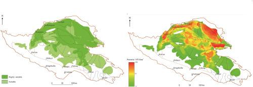
China has pledged to peak carbon dioxide (CO2) emissions by 2030 and achieve carbon neutrality by 2060. Carbon capture and storage (CCS) will play a key role in these efforts. Over the past several years, the China Geological Survey (CGS) has completed the Suitability Evaluation Map of CO2 Geological Storage in Main Sedimentary Basins in China and Adjacent Sea Regions in 2017. This map reflects the suitability of the first- and secondary-order tectonic units within sedimentary basins for CO2 geological storage for CCS planning. The Junggar Basin is recognized as an important region for future CCS projects. Results from a mesoscale evaluation using the volume method indicate that deep saline aquifers represent the most significant resources for CO2 storage, with potential ranging from 48 × 109 to 164 × 109 t (with a P50 value of 96 × 109 t). The highest storage potential is identified in the central and northern parts of the basin, reaching up to 9.5 × 106 t/km2 at the P50 probability level. In contrast, the hinterland, eastern, and western parts of the basin generally exhibit storage potential of below 1.0 × 106 t/km2 at the same probability level. The CGS has also characterized historical CO2 plume migration in reservoirs at the storage site of the Shenhua CCS demonstration project and conducted numerical simulations of CO2 plume migration for periods of 10 and 20 years following the shutdown of the injection well. The CGS implemented a kiloton-scale pilot test on CO2-enhanced water recovery (CO2-EWR) in eastern Junggar, revealing that CO2 flooding can improve the pressure for fluid production, with the highest ratio of CO2 to produced fluids estimated at approximately 1.2. Besides, an observation field for natural CO2 leakage, covering about 930 m2, was built in Qinghai Province. In natural CO2 fields or at artificial CO2 injection research sites, CO2 leakage points are primarily related to the distribution of faults (especially fault crossing), which can serve as pathways for CO2 leakage. The observation field provides a natural analog to wellbore failure and offers an opportunity to further monitor CO2 geological storage sites. However, it has been inferred that borehole ZK10 at the observation field has become a leakage pathway due to the drilling activities, inadequate well-plugging, and abandonment procedures without considering CO2 corrosion.

Abstract Image

沉积盆地的二氧化碳地质储存:潜力和适宜性评价和现场试验的最新进展
中国承诺到2030年达到二氧化碳排放峰值,到2060年实现碳中和。碳捕集与封存(CCS)将在这些努力中发挥关键作用。经过几年的努力,中国地质调查局于2017年完成了《中国主要沉积盆地及邻海区二氧化碳地质封存适宜性评价图》。该图反映了沉积盆地内一级和二级构造单元对CCS规划中CO2地质储存的适宜性。准噶尔盆地被认为是未来CCS项目的重要区域。利用体积法进行的中尺度评价结果表明,深层咸水层是最重要的CO2储存资源,其潜力范围为48 × 109 ~ 164 × 109 t (P50值为96 × 109 t),在P50概率水平上,盆地中部和北部的储存潜力最高,达到9.5 × 10⁶ t/km2。而在相同的概率水平上,盆地腹地、东部和西部的库存量潜力普遍低于1.0 × 106 t/km2。CGS还描述了神华CCS示范项目储存区储层中CO2羽流的历史迁移特征,并对注水井关闭后10年和20年的CO2羽流迁移进行了数值模拟。CGS在准噶尔东部进行了一项千吨规模的二氧化碳提高采收率(CO2- ewr)中试,结果表明,二氧化碳驱油可以提高流体生产压力,二氧化碳与产出流体的最高比值估计约为1.2。在青海省建立了一个面积约930平方米的CO2自然泄漏观测场。在天然CO2场或人工CO2注入研究点,CO2泄漏点主要与断层(尤其是断层交叉)的分布有关,断层交叉是CO2泄漏的通道。该观测现场提供了对井筒破坏的自然模拟,并提供了进一步监测二氧化碳地质储存地点的机会。但可以推断,由于钻井活动、封堵不到位、弃井未考虑CO2腐蚀等原因,观测场ZK10井已成为泄漏通道。
本文章由计算机程序翻译,如有差异,请以英文原文为准。
求助全文
约1分钟内获得全文 求助全文
来源期刊
CiteScore
8.20
自引率
0.00%
发文量
0
×
引用
GB/T 7714-2015
复制
MLA
复制
APA
复制
导出至
BibTeX EndNote RefMan NoteFirst NoteExpress
×
提示
您的信息不完整,为了账户安全,请先补充。
现在去补充
×
提示
您因"违规操作"
具体请查看互助需知
我知道了
×
提示
确定
请完成安全验证×
copy
已复制链接
快去分享给好友吧!
我知道了
右上角分享
点击右上角分享
0
联系我们:info@booksci.cn Book学术提供免费学术资源搜索服务,方便国内外学者检索中英文文献。致力于提供最便捷和优质的服务体验。 Copyright © 2023 布克学术 All rights reserved.
京ICP备2023020795号-1
ghs 京公网安备 11010802042870号
Book学术文献互助
Book学术文献互助群
群 号:604180095
Book学术官方微信