Uncovering the seasonal dynamics of terrestrial oil spills through multi-temporal and multi-frequency Synthetic Aperture radar (SAR) observations
IF 7.6
Q1 REMOTE SENSING
International journal of applied earth observation and geoinformation : ITC journal
Pub Date : 2024-12-01
DOI:10.1016/j.jag.2024.104286
引用次数: 0
Abstract
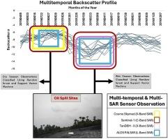
The phenological characteristics of vegetation exposed to oil pollution can reveal how different vegetation types and species respond to the effects of hydrocarbons in crude oil. This can further inform the recovery status and remediation efforts on polluted sites. In this study, the potential of various SAR frequencies (including multitemporal C band Sentinel-1, X band Cosmo Skymed, X band TanDEM-X, and L band ALOS PALSAR 2) were explored to analyse the characteristics of vegetation affected by hydrocarbons over time. The SAR backscatter characteristics of both oil-polluted and oil-free vegetation were systematically examined across different seasons to deduce the primary effects of oil pollution. Additionally, machine learning random forest (RF) classification and support vector machines (SVM) were implemented on seasonal image composites to assess spatial extent. Results show that stress caused by oil pollution on vegetation is better distinguishable during the wet season in the VV channel than in the VH channel of the multitemporal Sentinel 1. This was supported by the machine learning classification, as overall accuracy (OA) and Kappa (K) were also highest with the wet season SAR image composites. A further incorporation of L- and X-Band multifrequency SAR across the two seasons showed that the wet season composites significantly improved the classification accuracy, with Cropland, Grassland and Tree Cover Area (TCA) recording an increase in OA and K, to 82.3 % and 0.64, 66.67 % and 0.33, and 74.7 % and 0.49, respectively. Findings presented in this study represent a pioneering exploration of the capabilities of multi-temporal and multi-sensor SAR imagery in discriminating oil-impacted from healthy vegetation. This holds significant promise in evaluating the progress of environmental remediation, the regeneration of vegetation, and recovery efforts.
通过多时相、多频合成孔径雷达(SAR)观测揭示陆地溢油的季节动态
石油污染下植被的物候特征可以揭示不同植被类型和物种对原油中烃类物质影响的响应。这可以进一步为污染场地的恢复状况和修复工作提供信息。研究了不同SAR频率(包括C波段Sentinel-1、X波段Cosmo Skymed、X波段TanDEM-X和L波段ALOS PALSAR 2)的潜力,分析了碳氢化合物对植被的影响特征。系统分析了不同季节油污植被和非油污植被的SAR后向散射特征,以推断油污的主要影响。在此基础上,利用机器学习随机森林(RF)分类和支持向量机(SVM)对季节图像复合材料进行空间程度评估。结果表明,在VV通道中,油类污染对植被的胁迫在雨季比在VH通道中更容易识别。这得到了机器学习分类的支持,因为雨季SAR图像合成的总体精度(OA)和Kappa (K)也最高。进一步纳入L波段和x波段多频SAR后,两季的分类精度显著提高,其中农田、草地和树木覆盖面积(TCA)的OA和K分别增加到82.3%和0.64,66.67%和0.33,74.7%和0.49。本研究的发现代表了多时相和多传感器SAR图像在区分受石油影响的植被和健康植被方面的开创性探索。这对评估环境修复、植被再生和恢复工作的进展具有重要意义。
本文章由计算机程序翻译,如有差异,请以英文原文为准。
求助全文
约1分钟内获得全文
求助全文
来源期刊

International journal of applied earth observation and geoinformation : ITC journal
Global and Planetary Change, Management, Monitoring, Policy and Law, Earth-Surface Processes, Computers in Earth Sciences
CiteScore
12.00
自引率
0.00%
发文量
0
审稿时长
77 days
期刊介绍:
The International Journal of Applied Earth Observation and Geoinformation publishes original papers that utilize earth observation data for natural resource and environmental inventory and management. These data primarily originate from remote sensing platforms, including satellites and aircraft, supplemented by surface and subsurface measurements. Addressing natural resources such as forests, agricultural land, soils, and water, as well as environmental concerns like biodiversity, land degradation, and hazards, the journal explores conceptual and data-driven approaches. It covers geoinformation themes like capturing, databasing, visualization, interpretation, data quality, and spatial uncertainty.
 求助内容:
求助内容: 应助结果提醒方式:


