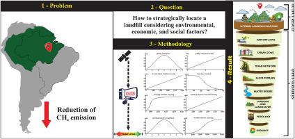
Geotechnological multicriteria analysis applied to identify optimal locations for the installation of sanitary landfills
IF 3.8
Q2 ENVIRONMENTAL SCIENCES
Remote Sensing Applications-Society and Environment
Pub Date : 2024-11-15
DOI:10.1016/j.rsase.2024.101398
引用次数: 0
Abstract
The Urban Solid Waste sector is one of the main contributors to methane emissions. Despite specific legislation, many Brazilian municipalities still maintain outdated waste dumps. Geotechnological tools, such as Fuzzy logic, can provide a viable and efficient solution. This research aimed to evaluate the current location and identify optimal sites for the implementation of sanitary landfills, using Fuzzy logic. We considered were slope, proximity to water bodies, urban areas, roads, and airports, land use and occupation, geology, and pedology. The results showed that the current dump location is inadequate due to its proximity to the airport, roads, and urban center. The suitability map revealed that 35.38% of the studied area has high to very high suitability. The new selected location to landfill having sufficient area, being distant from the airport and urban center, and complying with operational and logistical standards of proximity to highways and water bodies. The research confirms that the current Urban Solid Waste structure is not in compliance with regulations and that Fuzzy logic is effective in selecting sites for new sanitary landfills. This model can serve as a reference for other municipalities, contributing to more efficient and responsible waste management.

应用土工多标准分析确定卫生填埋场的最佳安装位置
城市固体废物部门是甲烷排放的主要贡献者之一。尽管有专门的法律规定,但巴西许多城市仍然保留着过时的垃圾堆放场。模糊逻辑等土工技术工具可以提供可行且高效的解决方案。这项研究旨在利用模糊逻辑评估当前位置,并确定实施卫生填埋场的最佳地点。我们考虑的因素包括坡度、与水体、城区、道路和机场的距离、土地使用和占用、地质和土壤学。结果表明,由于靠近机场、公路和城市中心,目前的垃圾堆放地点并不合适。适宜性地图显示,35.38% 的研究区域具有较高或非常高的适宜性。新选定的垃圾填埋场具有足够的面积,远离机场和城市中心,并符合靠近公路和水体的操作和物流标准。研究证实,目前的城市固体废弃物结构不符合法规要求,而模糊逻辑在选择新的卫生填埋场地点方面是有效的。该模型可作为其他城市的参考,有助于提高废物管理的效率和责任感。
本文章由计算机程序翻译,如有差异,请以英文原文为准。
求助全文
约1分钟内获得全文
求助全文
来源期刊
CiteScore
8.00
自引率
8.50%
发文量
204
审稿时长
65 days
期刊介绍:
The journal ''Remote Sensing Applications: Society and Environment'' (RSASE) focuses on remote sensing studies that address specific topics with an emphasis on environmental and societal issues - regional / local studies with global significance. Subjects are encouraged to have an interdisciplinary approach and include, but are not limited by: " -Global and climate change studies addressing the impact of increasing concentrations of greenhouse gases, CO2 emission, carbon balance and carbon mitigation, energy system on social and environmental systems -Ecological and environmental issues including biodiversity, ecosystem dynamics, land degradation, atmospheric and water pollution, urban footprint, ecosystem management and natural hazards (e.g. earthquakes, typhoons, floods, landslides) -Natural resource studies including land-use in general, biomass estimation, forests, agricultural land, plantation, soils, coral reefs, wetland and water resources -Agriculture, food production systems and food security outcomes -Socio-economic issues including urban systems, urban growth, public health, epidemics, land-use transition and land use conflicts -Oceanography and coastal zone studies, including sea level rise projections, coastlines changes and the ocean-land interface -Regional challenges for remote sensing application techniques, monitoring and analysis, such as cloud screening and atmospheric correction for tropical regions -Interdisciplinary studies combining remote sensing, household survey data, field measurements and models to address environmental, societal and sustainability issues -Quantitative and qualitative analysis that documents the impact of using remote sensing studies in social, political, environmental or economic systems

 求助内容:
求助内容: 应助结果提醒方式:


