Uncovering true significant trends in global greening
IF 3.8
Q2 ENVIRONMENTAL SCIENCES
Remote Sensing Applications-Society and Environment
Pub Date : 2024-10-11
DOI:10.1016/j.rsase.2024.101377
引用次数: 0
Abstract
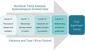
The global greening trend, marked by significant increases in vegetation cover across ecoregions, has attracted widespread attention. However, even robust traditional methods, like the non-parametric Mann-Kendall test, often overlook crucial factors such as serial correlation, spatial autocorrelation, and multiple testing, particularly in spatially gridded data. This oversight can lead to inflated significance of detected spatiotemporal trends. To address these limitations, this research introduces the True Significant Trends (TST) workflow, which enhances the conventional approach by incorporating pre-whitening to control for serial correlation, Theil-Sen (TS) slope for robust trend estimation, the Contextual Mann-Kendall (CMK) test to account for spatial and cross-correlation, and the adaptive False Discovery Rate (FDR) correction. Using AVHRR NDVI data over 42 years (1982–2023), we found that conventional workflow identified up to 50.96% of the Earth's terrestrial land surface as experiencing statistically significant vegetation trends. In contrast, the TST workflow reduced this to 38.16%, effectively filtering out spurious trends and providing a more accurate assessment. Among these significant trends identified using the TST workflow, 76.07% indicated greening, while 23.93% indicated browning. Notably, considering areas (pixels) with NDVI values above 0.15, greening accounted for 85.43% of the significant trends, with browning making up the remaining 14.57%. These findings strongly validate the ongoing global greening of vegetation. They also suggest that incorporating more robust analytical methods, such as the True Significant Trends (TST) approach, could significantly improve the accuracy and reliability of spatiotemporal trend analyses.

揭示全球绿化的真正重要趋势
以各生态区植被覆盖率显著增加为标志的全球绿化趋势已引起广泛关注。然而,即使是稳健的传统方法,如非参数 Mann-Kendall 检验法,也往往会忽略序列相关性、空间自相关性和多重检验等关键因素,尤其是在空间网格数据中。这种忽略会导致检测到的时空趋势的显著性被夸大。为了解决这些局限性,本研究引入了真实显著趋势(TST)工作流程,通过结合预白化控制序列相关性、Theil-Sen(TS)斜率进行稳健趋势估计、Contextual Mann-Kendall(CMK)检验考虑空间和交叉相关性以及自适应错误发现率(FDR)校正来增强传统方法。利用 42 年(1982-2023 年)的高级甚高分辨率辐射计 NDVI 数据,我们发现传统工作流程最多可识别出 50.96% 的地球陆地表面具有统计学意义的植被趋势。相比之下,TST 工作流程将这一比例降低到 38.16%,有效过滤了虚假趋势,提供了更准确的评估。在使用 TST 工作流程确定的这些重要趋势中,76.07% 表明植被正在变绿,23.93% 表明植被正在变褐。值得注意的是,考虑到 NDVI 值高于 0.15 的区域(像素),绿化占重要趋势的 85.43%,其余 14.57%为褐化。这些发现有力地证实了全球植被正在绿化。它们还表明,采用更稳健的分析方法,如真实显著趋势(TST)方法,可显著提高时空趋势分析的准确性和可靠性。
本文章由计算机程序翻译,如有差异,请以英文原文为准。
求助全文
约1分钟内获得全文
求助全文
来源期刊
CiteScore
8.00
自引率
8.50%
发文量
204
审稿时长
65 days
期刊介绍:
The journal ''Remote Sensing Applications: Society and Environment'' (RSASE) focuses on remote sensing studies that address specific topics with an emphasis on environmental and societal issues - regional / local studies with global significance. Subjects are encouraged to have an interdisciplinary approach and include, but are not limited by: " -Global and climate change studies addressing the impact of increasing concentrations of greenhouse gases, CO2 emission, carbon balance and carbon mitigation, energy system on social and environmental systems -Ecological and environmental issues including biodiversity, ecosystem dynamics, land degradation, atmospheric and water pollution, urban footprint, ecosystem management and natural hazards (e.g. earthquakes, typhoons, floods, landslides) -Natural resource studies including land-use in general, biomass estimation, forests, agricultural land, plantation, soils, coral reefs, wetland and water resources -Agriculture, food production systems and food security outcomes -Socio-economic issues including urban systems, urban growth, public health, epidemics, land-use transition and land use conflicts -Oceanography and coastal zone studies, including sea level rise projections, coastlines changes and the ocean-land interface -Regional challenges for remote sensing application techniques, monitoring and analysis, such as cloud screening and atmospheric correction for tropical regions -Interdisciplinary studies combining remote sensing, household survey data, field measurements and models to address environmental, societal and sustainability issues -Quantitative and qualitative analysis that documents the impact of using remote sensing studies in social, political, environmental or economic systems

 求助内容:
求助内容: 应助结果提醒方式:


