The TOPSIS method: Figuring the landslide susceptibility using Excel and GIS
IF 1.6
Q2 MULTIDISCIPLINARY SCIENCES
引用次数: 0
Abstract
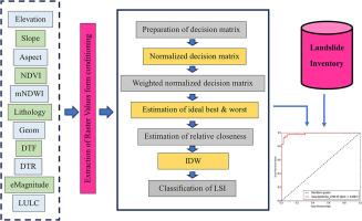
The current study introduced Technique for Order Preference by Similarity to Ideal Solution (TOPSIS) to enhance landslide susceptibility. It determines the relative distance of each alternative from the ideal best and ideal worst value. The ArcGIS environment was used to prepare eleven landslide conditioning factors, while raster values were extracted for the decision matrix preparation. We utilized subjective expert judgment to create a weighted matrix that considers the roles of each conditioning component. In addition, a Euclidean distance was measured from each alternative to the ideal best and worst values. The relative closeness value (Ri) has been used to prepare the landslide susceptibility index by the inverse distance weighting (IDW) interpolation. Furthermore, the precision of the landslide susceptibility was justified by area under curve-receiver operating characteristic (AUC-ROC) which was 0.987. Hence, multi-criteria decision-making (MCDM) techniques like the TOPSIS method are very useful for natural hazard mapping.
- •The simplified TOPSIS approach described by Hwang and Yoon (1981) is applied in this study. The criteria have been categorized and assigned weights based on expert judgment and previously published material.
- •The TOPSIS approach and GIS integration has significantly enhanced the creation of a landslide susceptibility map for a sensitive area.
- •The method is easiest and suitable for short term operation research.

TOPSIS 方法:使用 Excel 和 GIS 计算滑坡易发性
目前的研究引入了 "与理想方案相似度排序偏好技术"(TOPSIS),以提高滑坡的易发性。它确定了每个备选方案与理想最佳值和理想最坏值的相对距离。我们使用 ArcGIS 环境编制了 11 个滑坡条件因子,并提取了栅格值用于编制决策矩阵。我们利用专家的主观判断创建了一个加权矩阵,该矩阵考虑了每个调节因素的作用。此外,我们还测量了每个备选方案与理想的最佳值和最坏值之间的欧氏距离。通过反距离加权(IDW)插值法,利用相对接近值(Ri)来编制滑坡易感性指数。此外,曲线下面积-接收器工作特征(AUC-ROC)为 0.987,证明了滑坡易感性的精确性。因此,像 TOPSIS 方法这样的多标准决策(MCDM)技术对于绘制自然灾害地图非常有用。本研究采用了 Hwang 和 Yoon(1981 年)描述的简化 TOPSIS 方法,并根据专家判断和以前发表的资料对标准进行了分类和权重分配。
本文章由计算机程序翻译,如有差异,请以英文原文为准。
求助全文
约1分钟内获得全文
求助全文
来源期刊

MethodsX
Health Professions-Medical Laboratory Technology
CiteScore
3.60
自引率
5.30%
发文量
314
审稿时长
7 weeks
期刊介绍:
 求助内容:
求助内容: 应助结果提醒方式:


