{"title":"Exploring Jalisco's water quality: A comprehensive web tool for limnological and phytoplankton data","authors":"Cristofer Camarena-Orozco, Eduardo Juárez Carrillo, Martha Alicia Lara González, Edlin Guerra-Castro","doi":"10.1002/gdj3.277","DOIUrl":null,"url":null,"abstract":"<p>This study presents a comprehensive dataset of hydrological information gathered from five key eastern basins in Jalisco, Mexico. The dataset encompasses approximately 50 limnological variables and phytoplankton counts specifically for one of these basins. Water-quality data were collected by the State Water Commission of Jalisco, adhering to the methods outlined in the Official Mexican Norm ‘NOM-127’. Monthly samplings were conducted to assess environmental variables such as pH, temperature, oxygen, nutrients and heavy metals. Monitoring has been ongoing for three basins since 2009, while the remaining two basins have been monitored since 2015 and 2020. Phytoplankton data were obtained from monthly samples taken by the University of Guadalajara between 2014 and 2019 in Lake Cajititlán. The original data were cleaned and organized using tidy data principles, with codes accessible on GitHub. To facilitate data exploration and visualization, we developed a user-friendly web application with the Shiny package in R. This application enables users to explore the dataset through summary statistics tables, time series plots and phytoplankton community analysis. The dataset is accessible on Zenodo. The presented data hold significance for environmental and water-quality assessment and applications in machine learning, neural network models, community ecology and broader environmental research. Notably, the raw data, publicly accessible from the State Water Commission of Jalisco, have been previously utilized for these purposes. This dataset offers value due to its diverse limnological and phytoplankton variables, an extended time frame of availability, a curated and streamlined accessibility process and the inclusion of a web application for intuitive exploration and visualization.</p>","PeriodicalId":54351,"journal":{"name":"Geoscience Data Journal","volume":"11 4","pages":"495-503"},"PeriodicalIF":2.4000,"publicationDate":"2024-10-07","publicationTypes":"Journal Article","fieldsOfStudy":null,"isOpenAccess":false,"openAccessPdf":"https://onlinelibrary.wiley.com/doi/epdf/10.1002/gdj3.277","citationCount":"0","resultStr":null,"platform":"Semanticscholar","paperid":null,"PeriodicalName":"Geoscience Data Journal","FirstCategoryId":"89","ListUrlMain":"https://rmets.onlinelibrary.wiley.com/doi/10.1002/gdj3.277","RegionNum":3,"RegionCategory":"地球科学","ArticlePicture":[],"TitleCN":null,"AbstractTextCN":null,"PMCID":null,"EPubDate":"","PubModel":"","JCR":"Q2","JCRName":"GEOSCIENCES, MULTIDISCIPLINARY","Score":null,"Total":0}
引用次数: 0
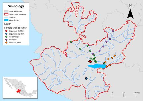
Abstract
This study presents a comprehensive dataset of hydrological information gathered from five key eastern basins in Jalisco, Mexico. The dataset encompasses approximately 50 limnological variables and phytoplankton counts specifically for one of these basins. Water-quality data were collected by the State Water Commission of Jalisco, adhering to the methods outlined in the Official Mexican Norm ‘NOM-127’. Monthly samplings were conducted to assess environmental variables such as pH, temperature, oxygen, nutrients and heavy metals. Monitoring has been ongoing for three basins since 2009, while the remaining two basins have been monitored since 2015 and 2020. Phytoplankton data were obtained from monthly samples taken by the University of Guadalajara between 2014 and 2019 in Lake Cajititlán. The original data were cleaned and organized using tidy data principles, with codes accessible on GitHub. To facilitate data exploration and visualization, we developed a user-friendly web application with the Shiny package in R. This application enables users to explore the dataset through summary statistics tables, time series plots and phytoplankton community analysis. The dataset is accessible on Zenodo. The presented data hold significance for environmental and water-quality assessment and applications in machine learning, neural network models, community ecology and broader environmental research. Notably, the raw data, publicly accessible from the State Water Commission of Jalisco, have been previously utilized for these purposes. This dataset offers value due to its diverse limnological and phytoplankton variables, an extended time frame of availability, a curated and streamlined accessibility process and the inclusion of a web application for intuitive exploration and visualization.
Geoscience Data JournalGEOSCIENCES, MULTIDISCIPLINARYMETEOROLOGY-METEOROLOGY & ATMOSPHERIC SCIENCES
CiteScore
5.90
自引率
9.40%
发文量
35
审稿时长
4 weeks
期刊介绍:
Geoscience Data Journal provides an Open Access platform where scientific data can be formally published, in a way that includes scientific peer-review. Thus the dataset creator attains full credit for their efforts, while also improving the scientific record, providing version control for the community and allowing major datasets to be fully described, cited and discovered.
An online-only journal, GDJ publishes short data papers cross-linked to – and citing – datasets that have been deposited in approved data centres and awarded DOIs. The journal will also accept articles on data services, and articles which support and inform data publishing best practices.
Data is at the heart of science and scientific endeavour. The curation of data and the science associated with it is as important as ever in our understanding of the changing earth system and thereby enabling us to make future predictions. Geoscience Data Journal is working with recognised Data Centres across the globe to develop the future strategy for data publication, the recognition of the value of data and the communication and exploitation of data to the wider science and stakeholder communities.


 求助内容:
求助内容: 应助结果提醒方式:


