Immediate assessment of forest fire using a novel vegetation index and machine learning based on multi-platform, high temporal resolution remote sensing images
IF 7.6
Q1 REMOTE SENSING
International journal of applied earth observation and geoinformation : ITC journal
Pub Date : 2024-10-11
DOI:10.1016/j.jag.2024.104210
引用次数: 0
Abstract
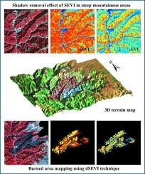
Forest fires pose a significant threat to ecosystems, biodiversity, and human settlements, necessitating accurate and timely detection of burned areas for post-fire management. This study focused on the immediate assessment of a recent major forest fire that occurred on March 15, 2024, in southwestern China. We comprehensively utilized high temporal resolution MODIS and Black Marble nighttime light images to monitor the fire’s development and introduced a novel method for detecting burned forest areas using a new Shadow-Enhanced Vegetation Index (SEVI) coupling with a machine learning technique. The SEVI effectively enhances the vegetation index (VI) values on shaded slopes and hence reduces the VI disparity between shaded and sunlit areas, which is critical for accurately extracting fire scars in such terrain. While SEVI primarily identifies burned forest areas, the Random Forest (RF) technique detects all burned areas, including both forested and non-forested regions. Consequently, the total burned area of the Yajiang forest fire was estimated at 23,588 ha, with the burned forest area covering 19,266 ha. The combination of SEVI and RF algorithms provided a comprehensive and efficient tool for identifying burned areas. Additionally, our study employed the Remote Sensing-based Ecological Index (RSEI) to assess the ecological impact of the fire on the region, uncovering an immediate 15 % decline in regional ecological conditions following the fire. The usage of RSEI has the potential to quantitatively understand ecological responses to the fire. The findings achieved in this study underscore the significance of precise fire-burned area extraction techniques for enhancing forest fire management and ecosystem recovery strategies, while also highlighting the broader ecological implications of such events.

利用基于多平台、高时间分辨率遥感图像的新型植被指数和机器学习对森林火灾进行即时评估
森林火灾对生态系统、生物多样性和人类居住区构成重大威胁,因此需要准确及时地探测火灾区域,以便进行火后管理。本研究的重点是对 2024 年 3 月 15 日发生在中国西南部的一场重大森林火灾进行即时评估。我们综合利用了高时间分辨率的 MODIS 和黑云母夜间光照图像来监测火灾的发展,并引入了一种新的方法,即利用新的阴影增强植被指数(SEVI)与机器学习技术相结合来检测烧毁林区。SEVI 可有效增强阴影斜坡上的植被指数(VI)值,从而缩小阴影和阳光照射区域之间的植被指数差异,这对于在此类地形中准确提取火烧痕至关重要。SEVI 主要识别烧毁的森林区域,而随机森林(RF)技术则检测所有烧毁区域,包括森林和非森林区域。因此,雅江森林火灾的总烧毁面积估计为 23,588 公顷,其中烧毁森林面积为 19,266 公顷。SEVI 算法和射频算法的结合为识别烧毁区域提供了一个全面、高效的工具。此外,我们的研究还采用了基于遥感的生态指数(RSEI)来评估火灾对该地区的生态影响,发现火灾发生后,该地区的生态条件立即下降了 15%。使用 RSEI 有可能从数量上了解火灾对生态的影响。本研究的发现强调了精确的火灾燃烧区提取技术对加强森林火灾管理和生态系统恢复战略的重要意义,同时也突出了此类事件对生态的广泛影响。
本文章由计算机程序翻译,如有差异,请以英文原文为准。
求助全文
约1分钟内获得全文
求助全文
来源期刊

International journal of applied earth observation and geoinformation : ITC journal
Global and Planetary Change, Management, Monitoring, Policy and Law, Earth-Surface Processes, Computers in Earth Sciences
CiteScore
12.00
自引率
0.00%
发文量
0
审稿时长
77 days
期刊介绍:
The International Journal of Applied Earth Observation and Geoinformation publishes original papers that utilize earth observation data for natural resource and environmental inventory and management. These data primarily originate from remote sensing platforms, including satellites and aircraft, supplemented by surface and subsurface measurements. Addressing natural resources such as forests, agricultural land, soils, and water, as well as environmental concerns like biodiversity, land degradation, and hazards, the journal explores conceptual and data-driven approaches. It covers geoinformation themes like capturing, databasing, visualization, interpretation, data quality, and spatial uncertainty.
 求助内容:
求助内容: 应助结果提醒方式:


