Estimation of district-level spring barley yield in southern Sweden using multi-source satellite data and random forest approach
IF 8.6
Q1 REMOTE SENSING
International journal of applied earth observation and geoinformation : ITC journal
Pub Date : 2024-10-01
DOI:10.1016/j.jag.2024.104183
引用次数: 0
Abstract
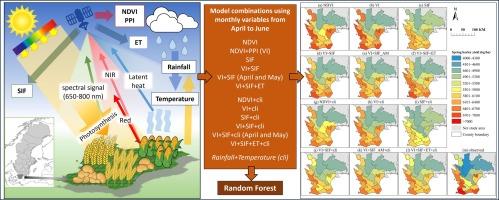
Remote sensing observations and artificial intelligence algorithms have emerged as key components for crop yield estimation at various scales during the past decades. However, the utilization of multi-source satellite data and machine learning for estimating aggregated crop yield at the regional level in Europe has been only scarcely explored. Our study aims to bridge this research gap by focusing on the district-level spring barley yield estimation in southern Sweden from 2017 to 2022. We developed an estimation method with the random forest (RF) approach using four satellite-derived products along with two climate variables. These variables were used individually and in combinations as inputs for the RF approach. The results showed that vegetation indices (VIs) outperformed solar-induced chlorophyll fluorescence (SIF) in barley yield estimation, while combining VIs and SIF variables achieved the highest model performance (R2 = 0.77, RMSE = 488 kg/ha). The inclusion of climate variables generally had little added contributions to the model performance. Importantly, barley yield prediction could be achieved two months prior to harvest, using monthly VIs and SIF data from April and May. Our study demonstrated the feasibility of using freely accessible satellite data and the machine learning approach for estimating crop yield at the pan-European regional level. We expect that our proposed methodology can be extended to different crop types and regional-scale crop yield estimation in Europe, benefiting national and local authorities in making agricultural productivity decisions.

利用多源卫星数据和随机森林方法估算瑞典南部地区级春大麦产量
过去几十年来,遥感观测和人工智能算法已成为各种规模作物产量估算的关键组成部分。然而,在欧洲,利用多源卫星数据和机器学习估算地区级作物总产量的研究还很少。我们的研究旨在弥补这一研究空白,重点关注瑞典南部地区 2017 年至 2022 年地区级春大麦产量估算。我们采用随机森林(RF)方法,利用四个卫星衍生产品和两个气候变量开发了一种估算方法。这些变量被单独或组合用作 RF 方法的输入。结果表明,在大麦产量估算中,植被指数(VIs)的表现优于太阳诱导叶绿素荧光(SIF),而将植被指数和 SIF 变量结合在一起则可获得最高的模型性能(R2 = 0.77,RMSE = 488 千克/公顷)。加入气候变量对模型性能的贡献一般不大。重要的是,利用 4 月和 5 月的月度 VIs 和 SIF 数据,可以在收获前两个月预测大麦产量。我们的研究证明了使用可免费获取的卫星数据和机器学习方法在泛欧区域层面估算作物产量的可行性。我们预计,我们提出的方法可以推广到欧洲不同的作物类型和区域范围的作物产量估算,从而有利于国家和地方当局做出农业生产力决策。
本文章由计算机程序翻译,如有差异,请以英文原文为准。
求助全文
约1分钟内获得全文
求助全文
来源期刊

International journal of applied earth observation and geoinformation : ITC journal
Global and Planetary Change, Management, Monitoring, Policy and Law, Earth-Surface Processes, Computers in Earth Sciences
CiteScore
12.00
自引率
0.00%
发文量
0
审稿时长
77 days
期刊介绍:
The International Journal of Applied Earth Observation and Geoinformation publishes original papers that utilize earth observation data for natural resource and environmental inventory and management. These data primarily originate from remote sensing platforms, including satellites and aircraft, supplemented by surface and subsurface measurements. Addressing natural resources such as forests, agricultural land, soils, and water, as well as environmental concerns like biodiversity, land degradation, and hazards, the journal explores conceptual and data-driven approaches. It covers geoinformation themes like capturing, databasing, visualization, interpretation, data quality, and spatial uncertainty.
 求助内容:
求助内容: 应助结果提醒方式:


