A reservoir-based approach of the SWAT hydrological model in the Napanee River and Wilton Creek agricultural watersheds, Bay of Quinte
IF 2.4
3区 环境科学与生态学
Q3 ENVIRONMENTAL SCIENCES
引用次数: 0
Abstract
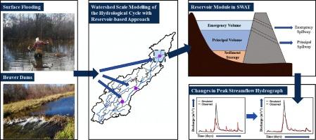
In this study, we employ the Soil and Water Assessment Tool (SWAT), to simulate the hydrological cycle in the Napanee River and Wilton Creek watersheds located in the Bay of Quinte Area of Concern. The geomorphological attributes of the two sites presented challenges in successfully reproducing the observed streamflow with a conceptual model, like SWAT. After adjusting the model inputs and revising the boundary conditions, SWAT performance for the Napanee River model was found to be “very good” within both calibration (Nash-Sutcliffe efficiency, NSE, =0.83 and NSE = 0.87 for the daily and monthly streamflow rates, respectively) and validation (NSE = 0.87 and NSE = 0.91) domains. In contrast, despite the small size of Wilton Creek (∼233 km2) and the lack of permanent or human-regulated dams, the observed streamflow patterns displayed considerably delayed response to extreme precipitation events which posed challenges in achieving satisfactory model performance. Field evidence suggests that model residual variability is driven by excessive surface storage of water, the presence of beaver dams and narrowing of the stream channels under the bridges, which could potentially delay the flow of water for many days. After delineating the areas of flooding and treating them as reservoirs in Wilton Creek, we were able to overcome the modelling challenges with minor modifications in the original SWAT configuration and achieve satisfactory fit for both the calibration (NSE = 0.55 and NSE = 0.73) and validation (NSE = 0.59 and NSE = 0.76) periods. Our study suggests that the reservoirs play a significant role in buffering the impact of extreme flow conditions, especially during the spring freshet

基于水库的 SWAT 水文模型在昆特湾纳帕尼河和威尔顿河农业流域的应用
在这项研究中,我们使用土壤和水评估工具 (SWAT) 模拟了位于昆特湾关注区的纳帕尼河和威尔顿河流域的水文循环。这两个地点的地貌特征给利用 SWAT 等概念模型成功再现观测到的溪流带来了挑战。在调整模型输入和修改边界条件后,SWAT 的纳帕尼河模型在校准(纳什-萨特克利夫效率 NSE = 0.83)和验证(纳什-萨特克利夫效率 NSE = 0.87 和纳什-萨特克利夫效率 NSE = 0.91)领域的表现都 "非常好"。相比之下,尽管威尔顿溪面积较小(233 平方公里),而且没有永久性或人为调节的水坝,但观测到的溪流模式对极端降水事件的响应却明显滞后,这给实现令人满意的模型性能带来了挑战。实地证据表明,模型的残余变化是由过多的地表蓄水、海狸坝的存在以及桥下河道的狭窄造成的,这可能会使水流延迟多日。在划定洪水泛滥区域并将其视为威尔顿溪的水库后,我们对原始 SWAT 配置进行了小幅修改,从而克服了建模难题,并在校准期(NSE = 0.55 和 NSE = 0.73)和验证期(NSE = 0.59 和 NSE = 0.76)取得了令人满意的拟合效果。我们的研究表明,水库在缓冲极端流量条件的影响方面发挥了重要作用,尤其是在春季新梢期
本文章由计算机程序翻译,如有差异,请以英文原文为准。
求助全文
约1分钟内获得全文
求助全文
来源期刊

Journal of Great Lakes Research
生物-海洋与淡水生物学
CiteScore
5.10
自引率
13.60%
发文量
178
审稿时长
6 months
期刊介绍:
Published six times per year, the Journal of Great Lakes Research is multidisciplinary in its coverage, publishing manuscripts on a wide range of theoretical and applied topics in the natural science fields of biology, chemistry, physics, geology, as well as social sciences of the large lakes of the world and their watersheds. Large lakes generally are considered as those lakes which have a mean surface area of >500 km2 (see Herdendorf, C.E. 1982. Large lakes of the world. J. Great Lakes Res. 8:379-412, for examples), although smaller lakes may be considered, especially if they are very deep. We also welcome contributions on saline lakes and research on estuarine waters where the results have application to large lakes.
 求助内容:
求助内容: 应助结果提醒方式:


