Camden G. Camacho, Alexander Antonison, Allison Oldnettle, Kaylie Anne Costa, Alina S. Timshina, Heather Ditz, Jake T. Thompson, Mackenzie M. Holden, William J. Sobczak, Jack Arnold, Mitchell Kozakoff, Kaitlyn Tucker, Hannah J. Brown, Rita Hippe, Courtney L. Kennedy, Lauren E. Blackman, Sanneri E. Santiago Borrés, Joe Aufmuth, Keyla Correia, Brian Martinez, Todd Z. Osborne, John A. Bowden
{"title":"Statewide Surveillance and Mapping of PFAS in Florida Surface Water","authors":"Camden G. Camacho, Alexander Antonison, Allison Oldnettle, Kaylie Anne Costa, Alina S. Timshina, Heather Ditz, Jake T. Thompson, Mackenzie M. Holden, William J. Sobczak, Jack Arnold, Mitchell Kozakoff, Kaitlyn Tucker, Hannah J. Brown, Rita Hippe, Courtney L. Kennedy, Lauren E. Blackman, Sanneri E. Santiago Borrés, Joe Aufmuth, Keyla Correia, Brian Martinez, Todd Z. Osborne, John A. Bowden","doi":"10.1021/acsestwater.4c00272","DOIUrl":null,"url":null,"abstract":"Florida’s water bodies are vital for drinking, agriculture, recreation, tourism, and climate resilience. The monitoring of water quality is critical for the state, with consequences for both human health and the economy. This work describes our statewide monitoring of per- and polyfluoroalkyl substances (PFAS) within a myriad of water bodies in Florida to establish a PFAS baseline and determine hotspots. Surface water samples were obtained between April 2020 and December 2021, from 2323 sites, via crowdsourcing from all 67 counties in Florida and were subsequently analyzed for 50 PFAS via high-performance liquid chromatography-tandem mass spectrometry. The mean concentration of ∑PFAS across Florida was 29 ng/L, with a maximum ∑PFAS concentration of 3048 ng/L. Moreover, 23 counties reported perfluorooctanoic acid and perfluorooctanesulfonic acid levels over the EPA’s maximum contaminant level of 4 ng/L, with 915 and 920 sites over the limit across the state, respectively. Data was organized by site coordinates, and predictive heat maps highlighting regions of concern were created. First attempts were made to identify possible PFAS pollution sources by overlaying suspect entities (airports, military installations, and wastewater treatment plants), in addition to relating data to historical pollution spill notifications (e.g., wastewater influent, effluent, and sludge).","PeriodicalId":7078,"journal":{"name":"ACS Es&t Water","volume":"44 1","pages":""},"PeriodicalIF":0.0000,"publicationDate":"2024-09-18","publicationTypes":"Journal Article","fieldsOfStudy":null,"isOpenAccess":false,"openAccessPdf":"","citationCount":"0","resultStr":null,"platform":"Semanticscholar","paperid":null,"PeriodicalName":"ACS Es&t Water","FirstCategoryId":"1085","ListUrlMain":"https://doi.org/10.1021/acsestwater.4c00272","RegionNum":0,"RegionCategory":null,"ArticlePicture":[],"TitleCN":null,"AbstractTextCN":null,"PMCID":null,"EPubDate":"","PubModel":"","JCR":"","JCRName":"","Score":null,"Total":0}
引用次数: 0
Abstract
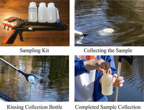
Florida’s water bodies are vital for drinking, agriculture, recreation, tourism, and climate resilience. The monitoring of water quality is critical for the state, with consequences for both human health and the economy. This work describes our statewide monitoring of per- and polyfluoroalkyl substances (PFAS) within a myriad of water bodies in Florida to establish a PFAS baseline and determine hotspots. Surface water samples were obtained between April 2020 and December 2021, from 2323 sites, via crowdsourcing from all 67 counties in Florida and were subsequently analyzed for 50 PFAS via high-performance liquid chromatography-tandem mass spectrometry. The mean concentration of ∑PFAS across Florida was 29 ng/L, with a maximum ∑PFAS concentration of 3048 ng/L. Moreover, 23 counties reported perfluorooctanoic acid and perfluorooctanesulfonic acid levels over the EPA’s maximum contaminant level of 4 ng/L, with 915 and 920 sites over the limit across the state, respectively. Data was organized by site coordinates, and predictive heat maps highlighting regions of concern were created. First attempts were made to identify possible PFAS pollution sources by overlaying suspect entities (airports, military installations, and wastewater treatment plants), in addition to relating data to historical pollution spill notifications (e.g., wastewater influent, effluent, and sludge).

 求助内容:
求助内容: 应助结果提醒方式:


