Ashutosh Rohta, Richa Upadhyay Sharma, Shovan L. Chattoraj
{"title":"Lithological Discrimination of Parts of the Bhukia Area, Banswara District, Rajasthan Using Hyperspectral Data","authors":"Ashutosh Rohta, Richa Upadhyay Sharma, Shovan L. Chattoraj","doi":"10.1007/s12524-024-01955-6","DOIUrl":null,"url":null,"abstract":"<p>In developing countries, exploration and exploitation of mineral resources help create the infrastructure that can sustain the population and economic growth. Remote sensing makes a brilliant tool to boost this growth. Hyperspectral Remote Sensing has been a key technology in mineral exploration and mapping for some time now. In this study, Airborne Visible InfraRed Imaging Spectrometer – Next Generation (AVIRIS-NG) data with the high spatial and spectral resolution was deployed to map the metasedimentary rocks in parts of the Bhukia region of Banswara district, Rajasthan. Similarly, PRecursore IperSpettrale della Missione Applicativa (PRISMA) data is also utilized to achieve a similar goal. The rock spectra obtained from both the surface reflectance hyperspectral datasets after applying the processing techniques were compared against the USGS spectral library and the field/ laboratory spectra to identify the diagnostic spectral features. The spectral Angle Mapper algorithm was applied to both datasets and detected limestone, dolomite, phyllite, and quartzite rocks. Furthermore, absorption band parameters were estimated and interpreted to corroborate the chemistry of the rock which helped in the identification of limestones based on Al<sup>3+</sup>/ Mg<sup>2+</sup> content.</p>","PeriodicalId":17510,"journal":{"name":"Journal of the Indian Society of Remote Sensing","volume":"6 1","pages":""},"PeriodicalIF":2.2000,"publicationDate":"2024-09-03","publicationTypes":"Journal Article","fieldsOfStudy":null,"isOpenAccess":false,"openAccessPdf":"","citationCount":"0","resultStr":null,"platform":"Semanticscholar","paperid":null,"PeriodicalName":"Journal of the Indian Society of Remote Sensing","FirstCategoryId":"5","ListUrlMain":"https://doi.org/10.1007/s12524-024-01955-6","RegionNum":4,"RegionCategory":"地球科学","ArticlePicture":[],"TitleCN":null,"AbstractTextCN":null,"PMCID":null,"EPubDate":"","PubModel":"","JCR":"Q3","JCRName":"ENVIRONMENTAL SCIENCES","Score":null,"Total":0}
引用次数: 0
Abstract
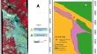
In developing countries, exploration and exploitation of mineral resources help create the infrastructure that can sustain the population and economic growth. Remote sensing makes a brilliant tool to boost this growth. Hyperspectral Remote Sensing has been a key technology in mineral exploration and mapping for some time now. In this study, Airborne Visible InfraRed Imaging Spectrometer – Next Generation (AVIRIS-NG) data with the high spatial and spectral resolution was deployed to map the metasedimentary rocks in parts of the Bhukia region of Banswara district, Rajasthan. Similarly, PRecursore IperSpettrale della Missione Applicativa (PRISMA) data is also utilized to achieve a similar goal. The rock spectra obtained from both the surface reflectance hyperspectral datasets after applying the processing techniques were compared against the USGS spectral library and the field/ laboratory spectra to identify the diagnostic spectral features. The spectral Angle Mapper algorithm was applied to both datasets and detected limestone, dolomite, phyllite, and quartzite rocks. Furthermore, absorption band parameters were estimated and interpreted to corroborate the chemistry of the rock which helped in the identification of limestones based on Al3+/ Mg2+ content.
期刊介绍:
The aims and scope of the Journal of the Indian Society of Remote Sensing are to help towards advancement, dissemination and application of the knowledge of Remote Sensing technology, which is deemed to include photo interpretation, photogrammetry, aerial photography, image processing, and other related technologies in the field of survey, planning and management of natural resources and other areas of application where the technology is considered to be appropriate, to promote interaction among all persons, bodies, institutions (private and/or state-owned) and industries interested in achieving advancement, dissemination and application of the technology, to encourage and undertake research in remote sensing and related technologies and to undertake and execute all acts which shall promote all or any of the aims and objectives of the Indian Society of Remote Sensing.
 求助内容:
求助内容: 应助结果提醒方式:


