V. V. Rozhnov, A. L. Salman, A. A. Yachmennikova, A. A. Lushchekina, P. A. Salman
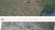
{"title":"Automated Identification and Counting of Saigas (Saiga tatarica) by Using Deep Convolutional Neural Networks in High-Resolution Satellite Images","authors":"V. V. Rozhnov, A. L. Salman, A. A. Yachmennikova, A. A. Lushchekina, P. A. Salman","doi":"10.1134/s1062359024608784","DOIUrl":null,"url":null,"abstract":"<h3 data-test=\"abstract-sub-heading\">Abstract</h3><p>We utilized a two-phase analysis using deep convolutional neural networks (DCNN) to create an automated technology that enabled us to detect and count saigas (<i>Saiga tatarica</i>) in satellite images with a resolution of 0.3–0.5 m/pixel (Eros-B 2012; 2013 and Beijing KA 2022 satellites). In the first phase, the satellite image is automatically divided into sections and checked for the presence or absence of clusters of objects (the “classification” phase). Then, during the second phase, only the fragments of the satellite image where at least one saiga was previously found are analyzed (the “detection” phase). The method was calibrated by training a neural network on the results of the preliminary processing of archival satellite images from 2012 and 2013, carried out manually by zoological experts. When we tested the DCNN work with a “confidence threshold” of 0.3, we identified 1284 saigas on the entire model satellite image, while a zoological expert manually identified 1412 saigas. For practical use and to assess the effectiveness of this method, we counted saigas on a 2022 image covering two adjacent specially protected natural areas (PAs) located in the Republic of Kalmykia and the Astrakhan region (Russian Federation). The results are presented with different “thresholds of confidence.”</p>","PeriodicalId":55366,"journal":{"name":"Biology Bulletin","volume":"28 1","pages":""},"PeriodicalIF":0.5000,"publicationDate":"2024-09-10","publicationTypes":"Journal Article","fieldsOfStudy":null,"isOpenAccess":false,"openAccessPdf":"","citationCount":"0","resultStr":null,"platform":"Semanticscholar","paperid":null,"PeriodicalName":"Biology Bulletin","FirstCategoryId":"99","ListUrlMain":"https://doi.org/10.1134/s1062359024608784","RegionNum":4,"RegionCategory":"生物学","ArticlePicture":[],"TitleCN":null,"AbstractTextCN":null,"PMCID":null,"EPubDate":"","PubModel":"","JCR":"Q4","JCRName":"BIOLOGY","Score":null,"Total":0}
引用次数: 0
Abstract
We utilized a two-phase analysis using deep convolutional neural networks (DCNN) to create an automated technology that enabled us to detect and count saigas (Saiga tatarica) in satellite images with a resolution of 0.3–0.5 m/pixel (Eros-B 2012; 2013 and Beijing KA 2022 satellites). In the first phase, the satellite image is automatically divided into sections and checked for the presence or absence of clusters of objects (the “classification” phase). Then, during the second phase, only the fragments of the satellite image where at least one saiga was previously found are analyzed (the “detection” phase). The method was calibrated by training a neural network on the results of the preliminary processing of archival satellite images from 2012 and 2013, carried out manually by zoological experts. When we tested the DCNN work with a “confidence threshold” of 0.3, we identified 1284 saigas on the entire model satellite image, while a zoological expert manually identified 1412 saigas. For practical use and to assess the effectiveness of this method, we counted saigas on a 2022 image covering two adjacent specially protected natural areas (PAs) located in the Republic of Kalmykia and the Astrakhan region (Russian Federation). The results are presented with different “thresholds of confidence.”
期刊介绍:
Biology Bulletin (Izvestiya Rossiiskoi Akademii Nauk – Seriya Biologicheskaya) is an interdisciplinary journal of general biology. It focuses on fundamental studies in the fields of cell biology, biochemistry, zoology, botany, physiology, and ecology. This journal publishes current materials of experimental studies and surveys on current problems in general biology. It also publishes information on scientific conferences and new books in the fields of general biology.
 求助内容:
求助内容: 应助结果提醒方式:


