Modeling the spatially varying effects of biophysical factors on land surface temperature

IF 1.6 Q2 MULTIDISCIPLINARY SCIENCES
MethodsX Pub Date : 2024-08-16 DOI:10.1016/j.mex.2024.102915
Getahun Bekele Debele , Kassahun Ture Beketie
{"title":"Modeling the spatially varying effects of biophysical factors on land surface temperature","authors":"Getahun Bekele Debele ,&nbsp;Kassahun Ture Beketie","doi":"10.1016/j.mex.2024.102915","DOIUrl":null,"url":null,"abstract":"<div><p>A growing number of studies have investigated how land surface temperature (LST) is influenced by a variety of driving factors; however, little effort has been made to identify the dominant ones. The suggested method used the Upper Awash Basin (UAB), Ethiopia, as an example to explore the spatial heterogeneity and factors affecting LST, which is critical for selecting effective mitigation strategies to manage the thermal environment. The study employed two models: ordinary least squares (OLS) and geographically weighted regression (GWR). The OLS model was first used to capture the overall relationship between LST and some biophysical factors. The GWR was then utilized to investigate the spatial non-stationary relationships between LST and its influencing biophysical factors. Although the method was tested in UAB, Ethiopia, it can be applied in similar agroecosystems, to identify the dominant factors that influence LST and develop site-specific LST mitigation strategies.</p><ul><li><span>•</span><span><p>The OLS and GWR models investigated the spatial heterogeneities of the influencing factors and LST.</p></span></li><li><span>•</span><span><p>Biophysical parameters such as enhanced vegetation index (EVI), modified normalized difference water index (MNDWI), normalized difference built-up index (NDBI), normalized difference bareness index (NDBaI), albedo and elevation were used as potential driving environmental factors of LST</p></span></li><li><span>•</span><span><p>The models performance was computed using the adjusted coefficient of determination (adj. R<sup>2</sup>), Akaike Information Criterion (AICc), and residual sum of squares (RSS).</p></span></li></ul></div>","PeriodicalId":18446,"journal":{"name":"MethodsX","volume":"13 ","pages":"Article 102915"},"PeriodicalIF":1.6000,"publicationDate":"2024-08-16","publicationTypes":"Journal Article","fieldsOfStudy":null,"isOpenAccess":false,"openAccessPdf":"https://www.sciencedirect.com/science/article/pii/S2215016124003662/pdfft?md5=bfdbbd52cb65a0eaddb443543fee41f6&pid=1-s2.0-S2215016124003662-main.pdf","citationCount":"0","resultStr":null,"platform":"Semanticscholar","paperid":null,"PeriodicalName":"MethodsX","FirstCategoryId":"1085","ListUrlMain":"https://www.sciencedirect.com/science/article/pii/S2215016124003662","RegionNum":0,"RegionCategory":null,"ArticlePicture":[],"TitleCN":null,"AbstractTextCN":null,"PMCID":null,"EPubDate":"","PubModel":"","JCR":"Q2","JCRName":"MULTIDISCIPLINARY SCIENCES","Score":null,"Total":0}
引用次数: 0

Abstract

A growing number of studies have investigated how land surface temperature (LST) is influenced by a variety of driving factors; however, little effort has been made to identify the dominant ones. The suggested method used the Upper Awash Basin (UAB), Ethiopia, as an example to explore the spatial heterogeneity and factors affecting LST, which is critical for selecting effective mitigation strategies to manage the thermal environment. The study employed two models: ordinary least squares (OLS) and geographically weighted regression (GWR). The OLS model was first used to capture the overall relationship between LST and some biophysical factors. The GWR was then utilized to investigate the spatial non-stationary relationships between LST and its influencing biophysical factors. Although the method was tested in UAB, Ethiopia, it can be applied in similar agroecosystems, to identify the dominant factors that influence LST and develop site-specific LST mitigation strategies.

  • The OLS and GWR models investigated the spatial heterogeneities of the influencing factors and LST.

  • Biophysical parameters such as enhanced vegetation index (EVI), modified normalized difference water index (MNDWI), normalized difference built-up index (NDBI), normalized difference bareness index (NDBaI), albedo and elevation were used as potential driving environmental factors of LST

  • The models performance was computed using the adjusted coefficient of determination (adj. R2), Akaike Information Criterion (AICc), and residual sum of squares (RSS).
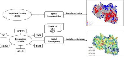

Abstract Image

模拟生物物理因素对地表温度的空间变化影响
越来越多的研究调查了陆地表面温度(LST)如何受到各种驱动因素的影响;但是,很少有人努力找出主导因素。所建议的方法以埃塞俄比亚上阿瓦士盆地(UAB)为例,探讨影响 LST 的空间异质性和因素,这对于选择有效的缓解策略来管理热环境至关重要。研究采用了两种模型:普通最小二乘法(OLS)和地理加权回归(GWR)。OLS 模型首先用于捕捉 LST 与一些生物物理因素之间的总体关系。然后利用地理加权回归研究 LST 与其影响的生物物理因子之间的空间非平稳关系。虽然该方法在埃塞俄比亚 UAB 进行了测试,但它可用于类似的农业生态系统,以确定影响 LST 的主要因素,并制定针对具体地点的 LST 缓解战略。-将增强植被指数(EVI)、修正归一化差异水指数(MNDWI)、归一化差异堆积指数(NDBI)、归一化差异裸露指数(NDBaI)、反照率和海拔高度等生物物理参数作为 LST 的潜在驱动环境因素。
本文章由计算机程序翻译,如有差异,请以英文原文为准。
求助全文
约1分钟内获得全文 求助全文
来源期刊
MethodsX
MethodsX Health Professions-Medical Laboratory Technology
CiteScore
3.60
自引率
5.30%
发文量
314
审稿时长
7 weeks
期刊介绍:
×
引用
GB/T 7714-2015
复制
MLA
复制
APA
复制
导出至
BibTeX EndNote RefMan NoteFirst NoteExpress
×
提示
您的信息不完整,为了账户安全,请先补充。
现在去补充
×
提示
您因"违规操作"
具体请查看互助需知
我知道了
×
提示
确定
请完成安全验证×
copy
已复制链接
快去分享给好友吧!
我知道了
右上角分享
点击右上角分享
0
联系我们:info@booksci.cn Book学术提供免费学术资源搜索服务,方便国内外学者检索中英文文献。致力于提供最便捷和优质的服务体验。 Copyright © 2023 布克学术 All rights reserved.
京ICP备2023020795号-1
ghs 京公网安备 11010802042870号
Book学术文献互助
Book学术文献互助群
群 号:481959085
Book学术官方微信