Urbanization and Suspended Sediment Transport Dynamics: A Comparative Study of Watersheds with Varying Degree of Urbanization Using Concentration-Discharge Hysteresis
引用次数: 0
Abstract
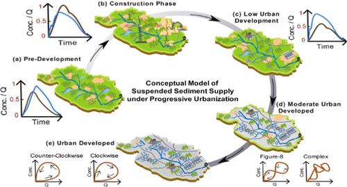
Suspended sediment is a critical water quality parameter and an indicator of geomorphic processes, but suspended sediment dynamics in urban streams may not conform to the first-flush model widely used for other pollutants. We analyzed discharge and turbidity data for 367 events from three urban watersheds (impervious cover 16–45%) in Cleveland, Ohio (USA). Less intensely urbanized watersheds exhibit higher turbidity compared to that of the most highly urbanized watershed. Proportionally, more counterclockwise hysteresis is observed in the two less urbanized watersheds, and more clockwise hysteresis occurs in the highly urbanized watershed. However, hysteresis patterns are driven by different mechanisms in each watershed, and geomorphic analysis was critical to identifying the underlying mechanisms. In the least urbanized watershed, spatial rainfall variability controls sediment hysteresis. In the intermediate watershed, the erosion of upstream weathered shale banks during dry periods plays a significant role in the sediment supply and shaping hysteresis. In the most urbanized watershed, high eroding banks in downstream reaches lead to more frequent clockwise hysteresis. Overall, we suggest that as the impervious surfaces increase, the availability of instream sediments (bed and banks) plays an increased role in suspended sediment dynamics, and geomorphology remains essential for guiding management decisions.
城市化与悬浮沉积物迁移动力学:利用浓度-排水滞后对不同城市化程度流域的比较研究
悬浮泥沙是一个重要的水质参数,也是地貌过程的指标,但城市河流中的悬浮泥沙动态可能不符合广泛用于其他污染物的首冲模型。我们分析了美国俄亥俄州克利夫兰市三个城市流域(不透水覆盖率为 16-45%)367 次事件的排放和浊度数据。与城市化程度最高的流域相比,城市化程度较低的流域浊度较高。从比例上看,在两个城市化程度较低的流域中,逆时针滞后现象较多,而在城市化程度较高的流域中,顺时针滞后现象较多。然而,每个流域的滞后模式都是由不同的机制驱动的,地貌分析对于确定其基本机制至关重要。在城市化程度最低的流域,空间降雨量的变化控制着泥沙滞后。在中等流域,上游风化页岩堤岸在干旱期的侵蚀对泥沙供应和滞后的形成起着重要作用。在城市化程度最高的流域,下游高侵蚀堤岸导致更频繁的顺时针滞后。总之,我们认为,随着不透水表面的增加,河流内沉积物(河床和河岸)的可用性在悬浮沉积物动力学中扮演着越来越重要的角色,地貌学对于指导管理决策仍然至关重要。
本文章由计算机程序翻译,如有差异,请以英文原文为准。
求助全文
约1分钟内获得全文
求助全文

 求助内容:
求助内容: 应助结果提醒方式:


