{"title":"Iranian mangrove degradation in oil spill from the 1990–91 Gulf War","authors":"Hana Etemadi, Esmaeil Abbasi","doi":"10.1007/s11273-024-10004-5","DOIUrl":null,"url":null,"abstract":"<p>Mangroves are highly susceptible to oil exposure. Oil spills cause long-lasting mangrove loss, threatening their conservation and ecosystem services worldwide. This study aimed to explore the impacts of the Gulf War oil spill, which occurred between August 1990 and February 1991, on mangrove vegetation in the Persian Gulf and Oman Sea regions (Nayband, Qheshm, Bandar-Abbas, Sirik, Jask, Gabrik and Govatre mangroves). We utilized remote sensing technologies to investigate the potential changes in mangrove area and health in response to the oil spill. The analysis of historical Landsat-derived Normalized Difference Vegetation Index (NDVI) data revealed significant degradation in the Nayband, Qheshm and Bandar-Abbas mangrove, which were closest to the contamination source. Results indicated that the oil spill degrades the mangroves around 17.7 ha with poor or moderate greenness and health condition in Nayband mangrove site (Bidkhoon and Basatin). The analysis in Qheshm mangroves revealed that the oil spill had a notable effect on mangroves in Classes 2 and 3, causing them to transition into Class 1, which represents weaker mangroves in terms of health and greenness. Also, the Bandar-Abbas mangrove area experienced a significant decline across all classes around 25%, or 129 hectares. These mangroves experienced greater reductions in overall area as well as declines in vegetation health. In contrast, the mangroves along the northern coast of the Oman Sea showed no evidence of area reduction due to oil contamination. Landward mangroves in Iran, which have lower NDVI values and higher oil concentrations in the sediment, are most susceptible to being lost due to oil spills. These mangroves have revealed their resilience and ability to undergo rapid recovery within 5 years after the Gulf war because the Iranian coastal mangrove areas were largely untouched and undeveloped, which provided a favorable environment. Additionally, the high temperatures and intense solar radiation in the region created a suitable condition for the degradation of the oil, further contributing to the mangroves’ recovery. This highlights the need for improved monitoring and conservation efforts to protect mangrove habitats, which are critical for supporting coastal communities and the broader environment.</p>","PeriodicalId":49363,"journal":{"name":"Wetlands Ecology and Management","volume":"282 1","pages":""},"PeriodicalIF":1.6000,"publicationDate":"2024-08-01","publicationTypes":"Journal Article","fieldsOfStudy":null,"isOpenAccess":false,"openAccessPdf":"","citationCount":"0","resultStr":null,"platform":"Semanticscholar","paperid":null,"PeriodicalName":"Wetlands Ecology and Management","FirstCategoryId":"93","ListUrlMain":"https://doi.org/10.1007/s11273-024-10004-5","RegionNum":4,"RegionCategory":"环境科学与生态学","ArticlePicture":[],"TitleCN":null,"AbstractTextCN":null,"PMCID":null,"EPubDate":"","PubModel":"","JCR":"Q4","JCRName":"ENVIRONMENTAL SCIENCES","Score":null,"Total":0}
引用次数: 0
Abstract
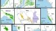
Mangroves are highly susceptible to oil exposure. Oil spills cause long-lasting mangrove loss, threatening their conservation and ecosystem services worldwide. This study aimed to explore the impacts of the Gulf War oil spill, which occurred between August 1990 and February 1991, on mangrove vegetation in the Persian Gulf and Oman Sea regions (Nayband, Qheshm, Bandar-Abbas, Sirik, Jask, Gabrik and Govatre mangroves). We utilized remote sensing technologies to investigate the potential changes in mangrove area and health in response to the oil spill. The analysis of historical Landsat-derived Normalized Difference Vegetation Index (NDVI) data revealed significant degradation in the Nayband, Qheshm and Bandar-Abbas mangrove, which were closest to the contamination source. Results indicated that the oil spill degrades the mangroves around 17.7 ha with poor or moderate greenness and health condition in Nayband mangrove site (Bidkhoon and Basatin). The analysis in Qheshm mangroves revealed that the oil spill had a notable effect on mangroves in Classes 2 and 3, causing them to transition into Class 1, which represents weaker mangroves in terms of health and greenness. Also, the Bandar-Abbas mangrove area experienced a significant decline across all classes around 25%, or 129 hectares. These mangroves experienced greater reductions in overall area as well as declines in vegetation health. In contrast, the mangroves along the northern coast of the Oman Sea showed no evidence of area reduction due to oil contamination. Landward mangroves in Iran, which have lower NDVI values and higher oil concentrations in the sediment, are most susceptible to being lost due to oil spills. These mangroves have revealed their resilience and ability to undergo rapid recovery within 5 years after the Gulf war because the Iranian coastal mangrove areas were largely untouched and undeveloped, which provided a favorable environment. Additionally, the high temperatures and intense solar radiation in the region created a suitable condition for the degradation of the oil, further contributing to the mangroves’ recovery. This highlights the need for improved monitoring and conservation efforts to protect mangrove habitats, which are critical for supporting coastal communities and the broader environment.
期刊介绍:
Wetlands Ecology and Management is an international journal that publishes authoritative and original articles on topics relevant to freshwater, brackish and marine coastal wetland ecosystems. The Journal serves as a multi-disciplinary forum covering key issues in wetlands science, management, policy and economics. As such, Wetlands Ecology and Management aims to encourage the exchange of information between environmental managers, pure and applied scientists, and national and international authorities on wetlands policy and ecological economics.
 求助内容:
求助内容: 应助结果提醒方式:


