Philipp Trusheim, Max Mehltretter, Franz Rottensteiner, Christian Heipke
{"title":"Cooperative Image Orientation with Dynamic Objects","authors":"Philipp Trusheim, Max Mehltretter, Franz Rottensteiner, Christian Heipke","doi":"10.1007/s41064-024-00296-w","DOIUrl":null,"url":null,"abstract":"<p>Using images to supplement classical navigation solutions purely based on global navigation satellite systems (GNSSs) has the potential to overcome problems in densely built-up areas. These approaches usually assume a static environment; however, this assumption is not necessarily valid in urban areas. Therefore, many approaches delete information stemming from moving objects in a first processing step, but this results in information being lost. In this paper, we present an approach that detects and models so-called dynamic objects based on image sequences and includes these object models into a bundle adjustment. We distinguish dynamic objects that provide information about their position to others (cooperating objects) and those that do not (non-cooperating objects). Dynamic objects that observe the environment with the help of sensors in order to determine their position are called observing objects. In the experiments discussed here, the observing object is equipped with a stereo camera and a GNSS receiver. We show that cooperating objects can have a positive effect on the exterior orientation of the observing object after the bundle adjustment, both in terms of precision and accuracy. However, we found that introducing non-cooperating objects did not result in further improvements, probably because in our case the photogrammetric block was already stable without them due to the large number and good distribution of static tie points.</p>","PeriodicalId":56035,"journal":{"name":"PFG-Journal of Photogrammetry Remote Sensing and Geoinformation Science","volume":"14 1","pages":""},"PeriodicalIF":3.3000,"publicationDate":"2024-07-26","publicationTypes":"Journal Article","fieldsOfStudy":null,"isOpenAccess":false,"openAccessPdf":"","citationCount":"0","resultStr":null,"platform":"Semanticscholar","paperid":null,"PeriodicalName":"PFG-Journal of Photogrammetry Remote Sensing and Geoinformation Science","FirstCategoryId":"89","ListUrlMain":"https://doi.org/10.1007/s41064-024-00296-w","RegionNum":4,"RegionCategory":"地球科学","ArticlePicture":[],"TitleCN":null,"AbstractTextCN":null,"PMCID":null,"EPubDate":"","PubModel":"","JCR":"Q3","JCRName":"IMAGING SCIENCE & PHOTOGRAPHIC TECHNOLOGY","Score":null,"Total":0}
引用次数: 0
Abstract
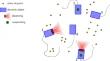
Using images to supplement classical navigation solutions purely based on global navigation satellite systems (GNSSs) has the potential to overcome problems in densely built-up areas. These approaches usually assume a static environment; however, this assumption is not necessarily valid in urban areas. Therefore, many approaches delete information stemming from moving objects in a first processing step, but this results in information being lost. In this paper, we present an approach that detects and models so-called dynamic objects based on image sequences and includes these object models into a bundle adjustment. We distinguish dynamic objects that provide information about their position to others (cooperating objects) and those that do not (non-cooperating objects). Dynamic objects that observe the environment with the help of sensors in order to determine their position are called observing objects. In the experiments discussed here, the observing object is equipped with a stereo camera and a GNSS receiver. We show that cooperating objects can have a positive effect on the exterior orientation of the observing object after the bundle adjustment, both in terms of precision and accuracy. However, we found that introducing non-cooperating objects did not result in further improvements, probably because in our case the photogrammetric block was already stable without them due to the large number and good distribution of static tie points.
期刊介绍:
PFG is an international scholarly journal covering the progress and application of photogrammetric methods, remote sensing technology and the interconnected field of geoinformation science. It places special editorial emphasis on the communication of new methodologies in data acquisition and new approaches to optimized processing and interpretation of all types of data which were acquired by photogrammetric methods, remote sensing, image processing and the computer-aided interpretation of such data in general. The journal hence addresses both researchers and students of these disciplines at academic institutions and universities as well as the downstream users in both the private sector and public administration.
Founded in 1926 under the former name Bildmessung und Luftbildwesen, PFG is worldwide the oldest journal on photogrammetry. It is the official journal of the German Society for Photogrammetry, Remote Sensing and Geoinformation (DGPF).
 求助内容:
求助内容: 应助结果提醒方式:


